2019年 第5卷 第5期
《工程(英文)》 >> 2019年 第5卷 第5期 doi: 10.1016/j.eng.2019.08.002
环境信息系统——为水管理数字化(Water 4.0)铺平道路
a Department of Environmental Informatics, Helmholtz Center for Environmental Research (UFZ), Leipzig 04318, Germany
b Applied Environmental Systems Analysis, Technische Universität Dresden, Dresden 01069, Germany
c UN Environment–Tongji Institute of Environment for Sustainable Development & College of Environmental Science and Engineering, Tongji University, Shanghai 200092, China
d Department for Ecological and Environmental Informatics, Institute of Geographical Sciences and Natural Resources Research, Chinese Academy of Sciences, Beijing 1000101, China
e Sino-German Research Center for Environmental Information Science (RCEIS), Leipzig 04318, Germany
下一篇 上一篇
图片
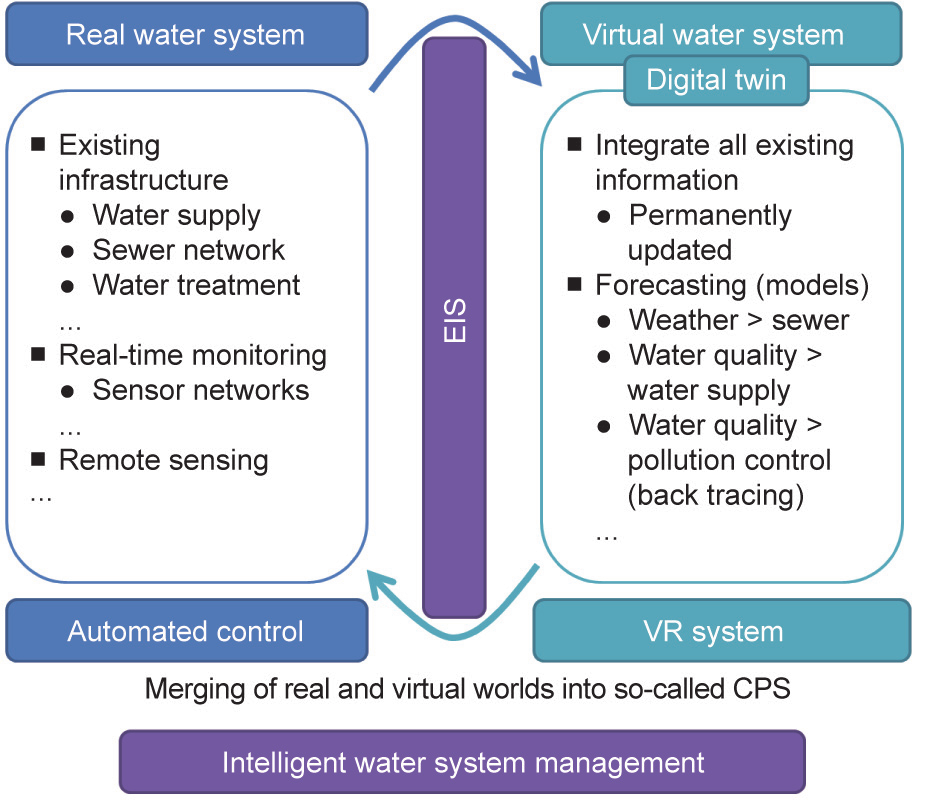
图1

图2
图3

图4

图5
参考文献
[ 1 ] Kunkel R, Sorg J, Eckardt R, Kolditz O, Rink K, Vereecken H. TEODOOR: a distributed geodata infrastructure for terrestrial observation data. Environ Earth Sci 2013;69(2):507–21. 链接1
[ 2 ] Wollschläger U, Attinger S, Borchardt D, Brauns M, Cuntz M, Dietrich P, et al. The Bode hydrological observatory: a platform for integrated, interdisciplinary hydro-ecological research within the TERENO Harz/Central German Lowland Observatory. Environ Earth Sci 2017;76(1):29. 链接1
[ 3 ] Vine MF, Degnan D, Hanchette C. Geographic information systems: their use in environmental epidemiologic research. Environ Health Perspect 1997;105 (6):598–605. 链接1
[ 4 ] Nuckols JR, Ward MH, Jarup L. Using geographic information systems for exposure assessment in environmental epidemiology studies. Environ Health Perspect 2004;112(9):1007–15. 链接1
[ 5 ] Kingston R, Carver S, Evans A, Turton I. Web-based public participation geographical information systems: an aid to local environ-mental decisionmaking. Comput Environ Urban Syst 2000;24(2):109–25. 链接1
[ 6 ] Kerschberg L. Expert database systems: knowledge/data management environments for intelligent information-systems. Inf Syst 1990;15 (1):151–60. 链接1
[ 7 ] European Commission. Communication from the commission to the council, the European Parliament, the European Economic and Social Committee and the Committee of the Regions—towards a shared environmental information system (SEIS). Technical report. Brussels: European Commission; 2008. 链接1
[ 8 ] Gu S, Fang C, Wang Y. Virtual geographic environment for WATLAC hydrological model integration. In: Proceedings of the 25th International Conference on Geoinformatics; 2017 Aug 2–4; New York, NY, USA; 2017.
[ 9 ] Melville NP. Information systems innovation for environmental sustainability. MIS Quart Manage Inf Syst 2010;34(1):1–21. 链接1
[10] Zhang B, Carter J. FORAGE—an online system for generating and delivering property-scale decision support information for grazing land and environmental management. Comput Electron Agric 2018;150:302–11. 链接1
[11] Fatehian S, Jelokhani-Niaraki M, Kakroodi AA, Dero QY, Samany NN. A volunteered geographic information system for managing environmental pollution of coastal zones: a case study in Nowshahr, Iran. Ocean Coast Manage 2018;163:54–65. 链接1
[12] Meiryani M, Susanto A, Warganegara DL. The issues influencing of environmental accounting information systems: an empirical investigation of SMEs in Indonesia. Inter J Energy Econom Policy 2019;9(1):282–90. 链接1
[13] Fitrios R, Susanto A, Soemantri R, Suharman H. The influence of environmental uncertainty on the accounting information system quality and its impact on the accounting information quality. J Theo Appl Inform Technol 2018;96 (21):7164–75. 链接1
[14] Aggestam F. Setting the stage for a shared environmental information system. Environ Sci Policy 2019;92:124–32. 链接1
[15] Jung E, Jung EJ. Service-oriented architecture of environmental information systems to forecast the impacts of natural disasters in Korea. J Enterp Inf Manag 2019;32(1):16–35. 链接1
[16] Khosrow-Pour M. Environmental information systems: concepts, methodologies, tools, and applications. Hershey: IGI Publishing; 2018. 链接1
[17] Sun Y, Xu Y. Thinking on the trend of environmental information system. IOP Conf Series Mater Sci Eng 2018;439(3):032064. 链接1
[18] Aronczyk M. Environment 1.0: infoterra and the making of environmental information. N Media Soc 2018;20(5):1832–49. 链接1
[19] Su T, Cao Z, Lv Z, Liu C, Li X. Multi-dimensional visualization of large-scale marine hydrological environ-mental data. Adv Eng Softw 2016;95:7–15. 链接1
[20] Lin H, Batty M, Jørgensen SE, Fu B, Konecny M, Voinov A, et al. Virtual environments begin to embrace process-based geographic analysis. Trans GIS 2015;19(4):493–8. 链接1
[21] Chen M, Lin H, Kolditz O, Chen C. Developing dynamic virtual geographic environments (VGEs) for geographic research. Environ Earth Sci 2015;74 (10):6975–80. 链接1
[22] Rink K, Fischer T, Selle B, Kolditz O. A data exploration framework for validation and setup of hydrological models. Environ Earth Sci 2013;69 (2):469–77. 链接1
[23] Bilke L, Fischer T, Helbig C, Krawczyk C, Nagel T, Naumov D, et al. TESSIN VISLab—laboratory for scientific visualization. Environ Earth Sci 2014;72 (10):3881–99. 链接1
[24] Helbig C, Bilke L, Bauer HS, Böttinger M, Kolditz O. MEVA—an interactive visualization application for validation of multifaceted meteorological data with multiple 3D devices. PLoS ONE 2015;10(4):e0123811. 链接1
[25] Lei T, Liang X, Mascaro G, Luo W, White D, Westerhoff P, et al. An interactive web-based geovisual analytics tool to explore water scarcity in Niger River Basin. In: Middel A, Rink K, Weber GH, editors. Workshop on visualisation in environmental sciences. Geneva: The Eurographics Association; 2015. 链接1
[26] Marbouti M, Bhaskar R, Zahra SHA, Anslow C, Jackson L, Maurer F. WaterVis: geovisual analytics for exploring hydrological data. Berlin: Springer; 2018. 链接1
[27] Rink K, Chen C, Bilke L, Liao Z, Rinke K, Frassl M, et al. Virtual geographic environments for water pollution control. Int J Digit Earth 2018;11 (4):397–407. 链接1
[28] Water Sedlak D. Water 4.0: the past, present, and future of the world’s most vital resource. New Haven: Yale University Press; 2014. 链接1
[29] Schaffer C, Vestner R, Bufler R, Werner U, Ziemer C. Wasser 4.0. Report. Berlin: German Water Partnership; 2017. German.
[30] Abdelhafidh M, Fourati M, Fourati LC, Abidi A. Remote water pipeline monitoring system IoT-based architecture for new industrial era 4.0. In: Proceedings of the 14th International Conference on Computer Systems and Applications; 2017 Oct 30–Nov 3; Hammamet, Tunisia; 2017.
[31] Baikousis B, Meyer H. IFAT 2018 shows the way to water management 4.0. Wasserwirtschaft 2018;108(5):50–1. 链接1
[32] Sachse A, Liao Z, Hu W, Dai X, Kolditz O, editors. Managing water resources for urban catchments: Chaohu. Heidelberg: Springer; 2019. 链接1
[33] Yue T, Nixdorf E, Zhou C, Xu B, Zhao N, Fan Z, editors. Poyang Lake Basin. Heidelberg: Springer; 2019. 链接1
[34] Zehner B, Watanabe N, Kolditz O. Visualization of gridded scalar data with uncertainty in geosciences. Comput Geosci 2010;36(10):1268–75. 链接1
[35] AMC—Analytik & Messtechnik GmbH Chemnitz [Internet]. Chemnitz: AMC; [cited 2019 May 15]. Available from: https://www.amc-systeme.de. 链接1
[36] WISUTEC Umwelttechnik GmbH [Internet]. Chemnitz: WISUTEC Umwelttechnik GmbH; [cited 2019 May 15]. Available from: https://www. wisutec.de/. 链接1
[37] Visualization Center [Internet]. Leipzig: Helmholtz Center for Environmental Research (UFZ); [cited 2019 May 15]. Available from: www.ufz.de/vislab. 链接1
[38] Rink K, Bilke L, Kolditz O. Visualisation strategies for environmental modelling data. Environ Earth Sci 2014;72(10):3857–68. 链接1
[39] Helbig C, Bauer HS, Rink K, Wulfmeyer V, Frank M, Kolditz O. Concept and workflow for 3D visualization of atmospheric data in a virtual reality environment for analytical approaches. Environ Earth Sci 2014;72 (10):3767–80. 链接1
[40] Unity Technologies [Internet]. Unity Technologies; [cited 2019 May 15]. Available from: https://unity3d.com. 链接1
[41] Rink K, Nixdorf E, Zhou C, Hillmann M, Bilke L. A virtual geographic environment for multi-compartment water and solute dynamics in large catchments. Technical report. Leipzig: Helmholtz Center for Environmental Research (UFZ); 2019. 链接1
[42] Du Y, Peng W, Wang S, Liu X, Chen C, Liu C, et al. Modeling of water quality evolution and response with the hydrological regime changes in Poyang Lake. Environ Earth Sci 2018;77(7):265. 链接1
[43] Wang J, Chen E, Li G, Zhang L, Cao X, Zhang Y, et al. Spatial and temporal variations of suspended solid concentrations from 2000 to 2013 in Poyang Lake, China. Environ Earth Sci 2018;77(16):590. 链接1
[44] Yan C, Rink K, Bilke L, Nixdorf E, Yue T, Kolditz O. Virtual geographical environment-based environmental information system for Poyang Lake Basin. In: Chinese water systems: Poyang Lake Basin. Heidelberg: Springer; 2019. p. 293–308.
[45] OpenGeoSys [Internet]. Leipzig: Helmholtz Center for Environmental Research (UFZ); [cited 2019 May 15]. Available from: www.opengeosys.org. 链接1
[46] Major M, Poulsen SE, Balling N. A numerical investigation of combined heat storage and extraction in deep geothermal reservoirs. Geothermal Energy 2018;6:1. 链接1
[47] Chavot P, Heimlich C, Masseran A, Serrano Y, Zoungrana J, Bodin C. Social shaping of deep geothermal projects in Alsace: politics, stakeholder attitudes and local democracy. Geothermal Energy 2018;6:26. 链接1
[48] Michalski A, Klitzsch N. Temperature sensor module for groundwater flow detection around borehole heat exchangers. Geothermal Energy 2018;6:15. 链接1
[49] Kalbacher T, Delfs JO, Shao H, Wang W, Walther M, Samaniego L, et al. The IWAS-ToolBox: software coupling for an integrated water resources management. Environ Earth Sci 2012;65(5):1367–80. 链接1
[50] Walther M, Bilke L, Delfs JO, Graf T, Grundmann J, Kolditz O, et al. Assessing the saltwater remediation potential of a three-dimensional, heterogeneous, coastal aquifer system: model verification, application and visualization for transient density-driven seawater intrusion. Environ Earth Sci 2014;72 (10):3827–37. 链接1
[51] Kalbacher T, Mettier R, McDermott C, Wang W, Kosakowski G, Taniguchi T, et al. Geometric modelling and object-oriented software concepts applied to a heterogeneous fractured network from the Grimsel rock laboratory. Computat Geosci 2007;11(1):9–26. 链接1
[52] Chen C, Börnick H, Cai Q, Dai X, Jähnig SC, Kong Y, et al. Challenges and opportunities of German–Chinese cooperation in water science and technology. Environ Earth Sci 2015;73(8):4861–71. 链接1


 京公网安备 11010502051620号


