2020年 第6卷 第8期
《工程(英文)》 >> 2020年 第6卷 第8期 doi: 10.1016/j.eng.2020.07.003
利用地球同步轨道InSAR每日生成DEM的质量分析
a School of Geosciences and Info-Physics, Central South University, Changsha 410083, China
b Department of Land Surveying and Geo-Informatics, The Hong Kong Polytechnic University, Hong Kong 999077, China
c China Aerospace Science and Technology Corporation, Beijing 100048, China
下一篇 上一篇
摘要
最新的数字高程模型(DEM)产品在灾害防治、城市管理等诸多领域中扮演着重要角色。利用机载或低地球轨道(LEO)的星载干涉合成孔径雷达(InSAR)生成DEM已被证明是可行且极具价值的方法。然而,受成本和卫星重返周期的限制,该技术难以频繁(如每天)生成或更新大区域范围(如大陆尺度或更大范围)的DEM。由于对地同步合成孔径雷达(GEOSAR)卫星运行于地球静止轨道,因此它们能以相当短的重返时间(每天或更短)观测同一地面区域,这为实现生成每日DEM这一理想但目前难以实现的目标提供了潜在可能。为此,本文系统地分析了利用GEOSAR卫星生成的每日DEM产品质量。结果表明:GEOSAR卫星生成的每日DEM产品精度通常远低于利用传统低轨星载合成孔径雷达(SAR)获得的DEM产品。因此,研究GEOSAR DEM生成过程中的误差削弱方法显得至关重要。
图片
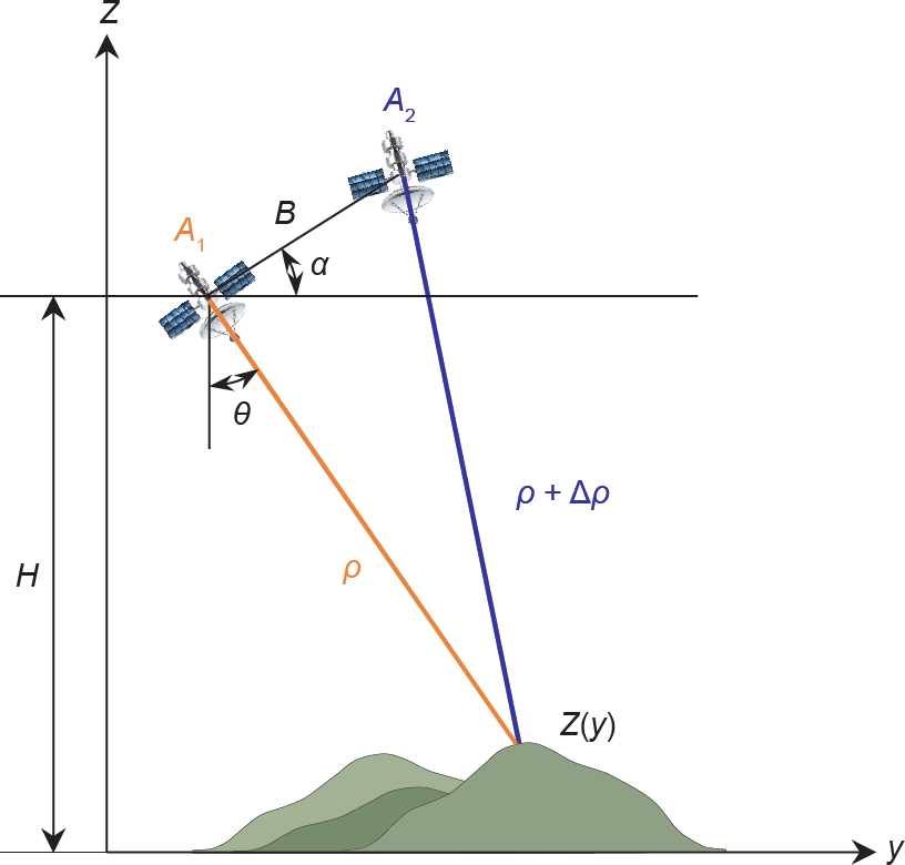
图1
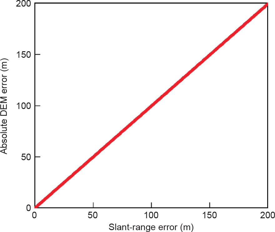
图2
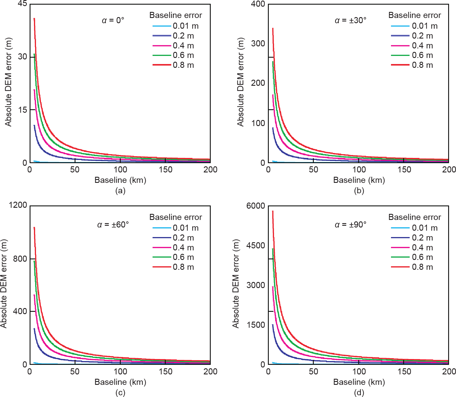
图3

图4

图5
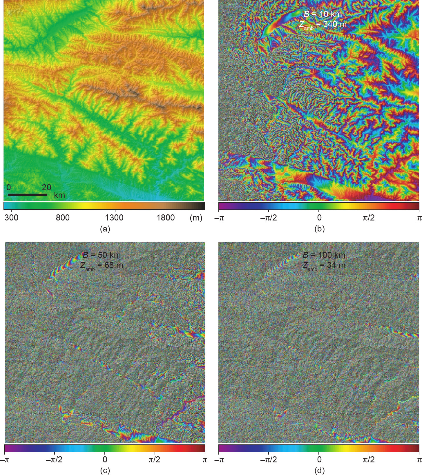
图6
参考文献
[ 1 ] Hanssen RF. Radar interferometry: data interpretation and error analysis. New York: Kluwer Academic Publishers; 2001. 链接1
[ 2 ] Farr TG, Rosen PA, Caro E, Crippen R, Duren R, Hensley S, et al. The shuttle radar topography mission. Rev Geophys 2007;45(2):RG2004. 链接1
[ 3 ] Ferretti A, Prati C, Rocca F. Multibaseline InSAR DEM reconstruction: the wavelet approach. IEEE Trans Geosci Remote Sens 1999;37(2):705–15. 链接1
[ 4 ] Rabus B, Eineder M, Roth A, Bamler R. The shuttle radar topography mission—a new class of digital elevation models acquired by spaceborne radar. ISPRS J Photogramm Remote Sens 2003;57(4):241–62. 链接1
[ 5 ] Gruber A, Wessel B, Huber M, Roth A. Operational TanDEM-X DEM calibration and first validation results. ISPRS J Photogramm Remote Sens 2012;73:39–49. 链接1
[ 6 ] Rizzoli P, Martone M, Gonzalez C, Wecklich C, Borla Tridon D, Bräutigam B, et al. Generation and performance assessment of the global TanDEM-X digital elevation model. ISPRS J Photogramm Remote Sens 2017;132:119–39. 链接1
[ 7 ] Tomiyasu K, Pacelli JL. Synthetic aperture radar imaging from an inclined geosynchronous orbit. IEEE Trans Geosci Remote Sens 1983;GE-21(3): 324–9. 链接1
[ 8 ] Tomiyasu K. Synthetic aperture radar in geosynchronous orbit. In: Proceedings of the 1978 Antennas and Propagation Society International Symposium; 1978 Mar 15–19; Washington, DC, USA; 1978. 链接1
[ 9 ] Guarnieri AM, Tebaldini S, Rocca F, Broquetas A. GEMINI: geosynchronous SAR for earth monitoring by interferometry and imaging. In: Proceedings of the 2012 IEEE International Geoscience and Remote Sensing Symposium; 2012 Jul 22–27; Munich, Germany; 2012. 链接1
[10] Chao B, Harding D, Cohen S, Luthcke S, Hofton M, Blair JB. Global Earthquake Satellite System requirements derived from a suite of scientific observational and modeling studies. Final Reports. Washington, DC: National Aeronautics and Space Administration; 2002. 链接1
[11] Hu C, Li Y, Dong X, Wang R, Cui C. Optimal 3D deformation measuring in inclined geosynchronous orbit SAR differential interferometry. Sci China Inf Sci 2017;60(6):060303. 链接1
[12] Zheng W, Hu J, Zhang W, Yang C, Li Z, Zhu J. Potential of geosynchronous SAR interferometric measurements in estimating three-dimensional surface displacements. Sci China Inf Sci 2017;60(6):060304. 链接1
[13] Hu C, Li Y, Dong X, Wang R, Cui C, Zhang B. Three-dimensional deformation retrieval in geosynchronous SAR by multiple-aperture interferometry processing: theory and performance analysis. IEEE Trans Geosci Remote Sens 2017;55(11):6150–69. 链接1
[14] Kou L, Wang X, Xiang M, Zhu M. Interferometric estimation of threedimensional surface deformation using geosynchronous circular SAR. IEEE Trans Aerosp Electron Syst 2012;48(2):1619–35. 链接1
[15] Ruiz-Rodon J, Broquetas A, Makhoul E, Monti Guarnieri A, Rocca F. Nearly zero inclination geosynchronous SAR mission analysis with long integration time for earth observation. IEEE Trans Geosci Remote Sens 2014;52(10):6379–91. 链接1
[16] Li D, Rodriguez-Cassola M, Prats-Iraola P, Dong Z, Wu M, Moreira A. Modelling of tropospheric delays in geosynchronous synthetic aperture radar. Sci China Inf Sci 2017;60(6):060307. 链接1
[17] Ji Y, Zhang Q, Zhang Y, Dong Z. L-band geosynchronous SAR imaging degradations imposed by ionospheric irregularities. Sci China Inf Sci 2017;60(6):060308. 链接1
[18] Zebker HA, Villasenor J. Decorrelation in interferometric radar echoes. IEEE Trans Geosci Remote Sens 1992;30(5):950–9. 链接1
[19] Bamler R, Hartl P. Synthetic aperture radar interferometry. Inverse Probl 1998;14(4):R1–R54. 链接1
[20] Zebker HA, Goldstein RM. Topographic mapping from interferometric synthetic aperture radar observations. J Geophys Res Solid Earth 1986;91(B5):4993–9. 链接1
[21] Rufino G, Moccia A, Esposito S. DEM generation by means of ERS tandem data. IEEE Trans Geosci Remote Sens 1998;36(6):1905–12. 链接1
[22] Ferraiuolo G, Pascazio V, Schirinzi G. Maximum a posteriori estimation of height profiles in InSAR imaging. IEEE Geosci Remote Sens Lett 2004;1(2):66–70. 链接1
[23] Chen CW, Zebker HA. Two-dimensional phase unwrapping with use of statistical models for cost functions in nonlinear optimization. J Opt Soc Am A 2001;18(2):338–51. 链接1
[24] Zhou C, Ge L, Dong C, Chang H. A case study of using external DEM in InSAR DEM generation. Geo Spat Inf Sci 2005;8(1):14–8. 链接1
[25] Long T, Hu C, Ding Z, Dong X, Tian W, Zeng T. Geosynchronous SAR: system and signal processing. Singapore: Springer Nature Singapore Pte Ltd.; 2018. 链接1
[26] Ishimaru A, Kuga Y, Liu J, Kim Y, Freeman T. Ionospheric effects on synthetic aperture radar at 100 MHz to 2 GHz. Radio Sci 1999;34(1):257–68. 链接1
[27] Sun J, Bi Y, Wang Y, Hong W. High resolution SAR performance limitation by the change of tropospheric refractivity. In: Proceedings of 2011 IEEE CIE International Conference on Radar; 2011 Oct 24–27; Chengdu; 2011. 链接1
[28] Hu C, Li Y, Dong X, Wang R, Ao D. Performance analysis of L-band geosynchronous SAR imaging in the presence of ionospheric scintillation. IEEE Trans Geosci Remote Sens 2017;55(1):159–72. 链接1
[29] Meyer FJ. Performance requirements for ionospheric correction of lowfrequency SAR data. IEEE Trans Geosci Remote Sens 2011;49(10):3694–702. 链接1
[30] Tian Y, Hu C, Dong X, Zeng T, Long T, Lin K, et al. Theoretical analysis and verification of time variation of background ionosphere on geosynchronous SAR imaging. IEEE Geosci Remote Sens Lett 2015;12(4):721–5. 链接1


 京公网安备 11010502051620号


