
2016, Volume 2, Issue 2
Engineering >> 2016, Volume 2, Issue 2 doi: 10.1016/J.ENG.2016.02.010
Autonomous Driving in the iCity—HD Maps as a Key Challenge of the Automotive Industry
a. International Management, Munich Business School, Munich 80687, Germany
b. UNITY Business Consulting (Shanghai) Co., Ltd., Shanghai 201203, China
Next Previous
Abstract
This article provides in-depth insights into the necessary technologies for automated driving in future cities. State of science is reflected from different perspectives such as in-car computing and data management, road side infrastructure, and cloud solutions. Especially the challenges for the application of HD maps as core technology for automated driving are depicted in this article.
Keywords
Autonomous driving ; Traffic infrastructure ; iCity ; Car-to-X communication ; Connected vehicle ; HD maps
Figures

Fig. 1

Fig. 2
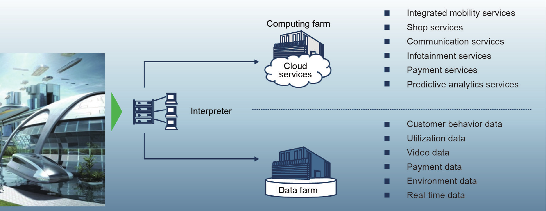
Fig. 3

Fig. 4
References
[ 1 ] Stayton EL. Driverless dreams: technological narratives and the shape of the automated car. Cambridge: Massachusetts Institute of Technology; 2015.
[ 2 ] Redzic O, Rabel D. A location cloud for highly automated driving. In: Meyer G,?Beiker S, editors Road vehicle automation 2. Switzerland: Springer International Publishing; 2015. p. 49–60.
[ 3 ] Dokic J, Müller B, Meyer G. European roadmap: smart systems for automated driving. Berlin: European Technology Platform on Smart Systems Integration; 2015.
[ 4 ] Jakubiec G, Mullinix B. The use of LiDAR technology in autonomous cruise control systems for automobiles. Conference Session C10, Paper #3124; 2013.
[ 5 ]
LiDAR boosts brain power for self-driving cars.Earth Imaging J [Internet].
[ 6 ]
Buechel M, Frtunikj J, Becker K,?Sommer S, Buckl C, Armbruster M, An automated electric vehicle prototype showing new trends in automotive architectures. In: Proceedings of 2015 IEEE 18th International Conference on Intelligent Transportation Systems;
[ 7 ] Marks P. Quantum positioning system steps in when GPS fails. New Sci 2014;222(2969):19.
[ 8 ]
Kent L. HERE introduces HD maps for highly automated vehicle testing [Internet].
[ 9 ] Sirui S. Towards autonomous driving at the limit of friction [dissertation]. Waterloo: University of Waterloo; 2015.
[10] Aeberhard M, Rauch S, Bahram M, Tanzmeister G, Thomas J, Pilat Y, Experience, results and lessons learned from automated driving on Germany´s highways. IEEE Intel Transp Sy 2015;7(1):42–57.
[11]
Ghosh A, Vardhan V, Mapp G,?Gemikonakli O,?Loo J. Providing ubiquitous communication using road-side units in VANET systems: unveiling the challenges. In: Proceedings of the 13th International Conference on ITS Telecommunications (ITST);
[12] Liu J, Wan J, Wang Q, Deng P, Zhou K, Qian Y. A survey on position-based routing for vehicular ad hoc networks. Telecommun Syst 2016;62(1):15–30. link1
[13]
Seif H, Tao M. Industrial round table: Industrie 4.0 technologies and Internet of Things and services in the city of the future [presentation]. In: The 3rd Sino-German CAE/acatech iCity Symposium; 2014
[14]
Kaiwartya O, Kumar S. Geocasting in vehicular adhoc networks using particle swarm optimization. In: Proceedings of the International Conference on Information Systems and Design of Communication;
[15] Kehoe B, Patil S,?Abbeel P,?Goldberg K. A survey of research on cloud robotics and automation. IEEE Trans Autom Sci Eng 2015;12(2):398–409. link1
[16]
Seif H. Autonomous driving in the iCity-HD maps as a key challenge of the automotive industry [presentation]. In: The 4th Sino-German CAE/acatech iCity Symposium;
[17] Moreno FA, Gonzalez-Jimenez J, Blanco JL, Esteban A. An instrumented vehicle for efficient and accurate 3D mapping of roads. Comput-Aided Civ Inf 2013;28(6):403–19. link1
[18] O´Neill-Dunne J. Image boost: drones produce sharper images for mapping. Roads Bridges 2015;53(9):30–2.
[19]
Presskey.com [Internet].Grand Cayman: Name Administration Inc.;


 京公网安备 11010502051620号


