
2018, Volume 4, Issue 5
Engineering >> 2018, Volume 4, Issue 5 doi: 10.1016/j.eng.2018.09.004
Reverse-Time Migration from Rugged Topography to Image Ground-Penetrating Radar Data in Complex Environments
a Department of Geosciences, Boise State University, Boise, ID 83725-1535, USA
b Department of Geosciences, Weber State University, Ogden, UT 84408-2507, USA
Next Previous
Abstract
In ground-penetrating radar (GPR) imaging, it is common for the depth of investigation to be on the same order as the variability in surface topography. In such cases, migration fails when it is carried out from a datum after the application of elevation statics. We introduce a reverse-time migration (RTM) algorithm based on the second-order decoupled form of Maxwell’s equations, which requires computation of only the electric field. The wavefield extrapolation is computed directly from the acquisition surface without the need for datuming. In a synthetic case study, the algorithm significantly improves image accuracy over a processing sequence in which migration is performed after elevation statics. In addition, we acquired a field dataset at the Coral Pink Sand Dunes (CPSD) in Utah, USA. The data were acquired over rugged topography and have the complex internal stratigraphy of multiply eroded, modern, and ancient eolian deposits. The RTM algorithm significantly improves radar depth images in this challenging environment.
Figures
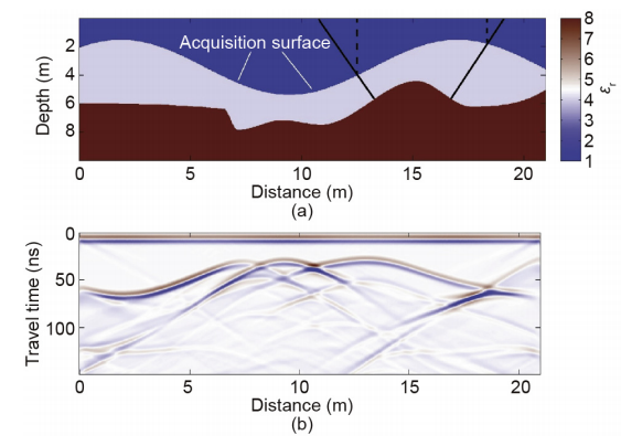
Fig.1

Fig.2

Fig.3
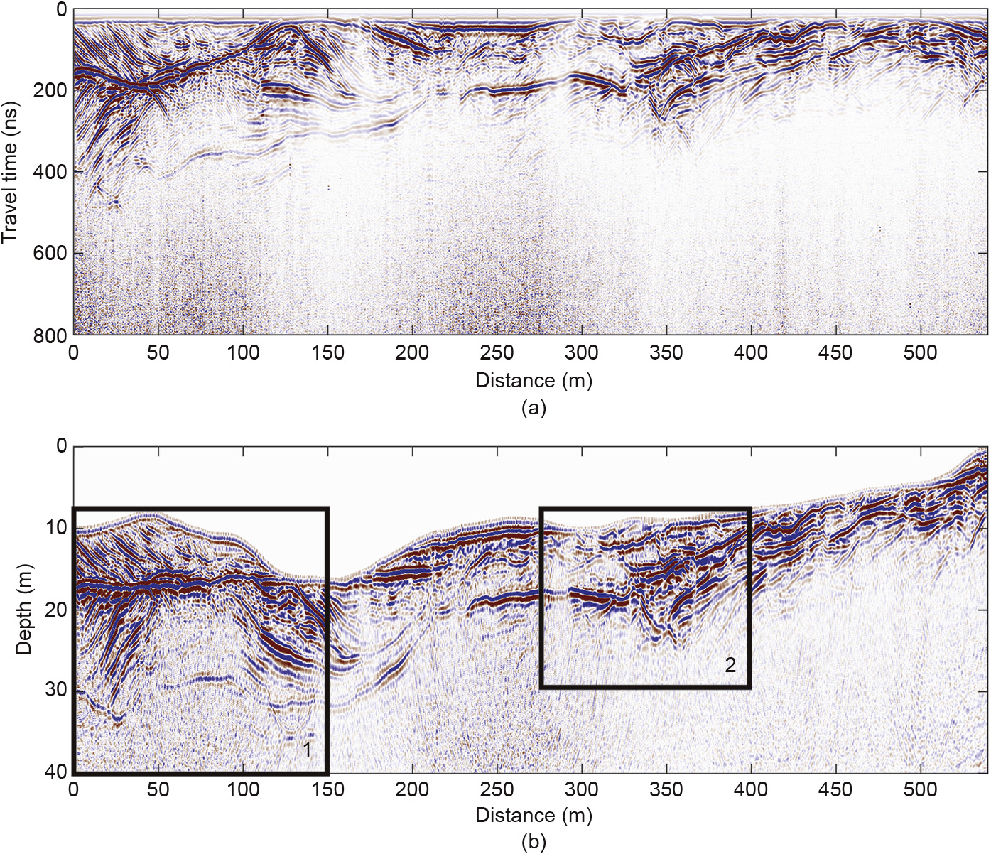
Fig.4

Fig.5

Fig.6
References
[ 1 ] Deng F, McMechan GA. True-amplitude prestack depth migration. Geophysics 2007;72(3):S155–66. link1
[ 2 ] Fisher E, McMechan GA, Annan AP, Cosway SW. Examples of reverse-time migration of single-channel, ground-penetrating radar profiles. Geophysics 1992;57(4):577–86. link1
[ 3 ] Sanada Y, Ashida Y. An imaging algorithm for GPR data. In: Powers MH, Cramer L, Bell RS, editors. Proceedings of the Symposium on the Application of Geophysics to Engineering and Environmental Problems; 1999 Mar 14–18; Oakland, CA, USA. Wheat Ridge: Environment and Engineering Geophysical Society; 1999. p. 565–73.
[ 4 ] Lehmann F, Green AG. Topographic migration of georadar data: implications for acquisition and processing. Geophysics 2000;65(3):836–48. link1
[ 5 ] Heincke B, Green AG, van der Kruk J, Horstmeyer H. Acquisition and processing strategies for 3D georadar surveying a region characterized by rugged topography. Geophysics 2005;70(6):K53–61. link1
[ 6 ] Heincke B, Green AG, van der Kruk J, Willenberg H. Semblance-based topographic migration (SBTM): a method for identifying fracture zones in 3D georadar data. Near Surf Geophys 2006;4(2):79–88. link1
[ 7 ] Zhu W, Huang Q. Application of reverse time migration on GPR data for detecting internal structures in a sand dune. In: Proceedings of the Society of Explorations Geophysicists 85th Annual International Exhibition and Meeting; 2015 Oct 18–23; New Orleans, LA, USA. Tulsa: Society of Exploration Geophysicists; 2015. p. 2269–74. link1
[ 8 ] Yee K. Numerical solution of initial boundary value problems involving Maxwell’s equations in isotropic media. IEEE Trans Antenn Propag 1966;14 (3):302–7. link1
[ 9 ] Zhou D, Huang WP, Xu CL, Fang DG, Chen B. The perfectly matched layer boundary condition for scalar finite-difference time-domain method. IEEE Photonics Technol Lett 2001;13(5):454–6. link1


 京公网安备 11010502051620号


