
2021, Volume 7, Issue 2
Engineering >> 2021, Volume 7, Issue 2 doi: 10.1016/j.eng.2020.12.011
A Survey of Sediment Fineness and Moisture Content in the Soyang Lake Floodplain Using GPS Data
Division of Science Education, Kangwon National University, Gangwon-do 24341, Republic of Korea
Next Previous
Abstract
Soyang Lake is the largest lake in Republic of Korea, bordering Chuncheon, Yanggu, and Inje in Gangwon Province. It is widely used as an environmental resource for hydropower, flood control, and water supply. Therefore, we conducted a survey of the floodplain of Soyang Lake to analyze the sediments in the area. We used global positioning system (GPS) data and aerial photography to monitor sediment deposits in the Soyang Lake floodplain. Data from three GPS units were compared to determine the accuracy of sampling location measurement. Sediment samples were collected at three sites: two in the eastern region of the floodplain and one in the western region. A total of eight samples were collected: Three samples were collected at 10 cm intervals to a depth of 30 cm from each site of the eastern sampling point, and two samples were collected at depths of 10 and 30 cm at the western sampling point. Samples were collected and analyzed for vertical and horizontal trends in particle size and moisture content. The sizes of the sediment samples ranged from coarse to very coarse sediments with a negative slope, which indicate eastward movement from the breach. The probability of a breach was indicated by the high water content at the eastern side of the floodplain, with the eastern sites showing a higher probability than the western sites. The results of this study indicate that analyses of grain fineness, moisture content, sediment deposits, and sediment removal rates can be used to understand and predict the direction of breach movement and sediment distribution in Soyang Lake.
Keywords
Soyang Lake ; Grain fineness number ; Moisture content ; GPS data ; Digital surface model
Figures

Fig. 1

Fig. 2
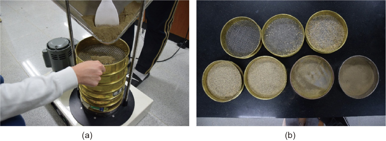
Fig. 3

Fig. 4

Fig. 5
References
[ 1 ] Leenaers H, Schouten CJ. Soil erosion and floodplain soil pollution: related problems in the geographical context of a river basin. In: Hadley RF, Ongley ED, editors. Sediment and the environment. Wallingford: IAHS Publication; 1989. p. 75–83. link1
[ 2 ] Shin HJ, Park MJ, Hwang EH, Chae HS, Park SJ. A study of spring drought using terra MODIS satellite image—for the Soyanggang Dam watershed. J Korean Assoc Geogr Inf Stud 2015;18(4):145–57. Korean. link1
[ 3 ] Lee SB, Kim Y, Kim J, Park Y. Detection of alteration in river area using landsat satellite imagery. J Korean Soc Hazard Mitigation 2017;17(3):391–8. Korean. link1
[ 4 ] Ordoyne C, Friedl MA. Using MODIS data to characterize seasonal inundation patterns in the Florida Everglades. Remote Sens Environ 2008;112 (11):4107–19. link1
[ 5 ] Ward DP, Petty A, Setterfield SA, Douglas MM, Ferdinands K, Hamilton SK, et al. Floodplain inundation and vegetation dynamics in the Alligator Rivers region (Kakadu) of northern Australia assessed using optical and radar remote sensing. Remote Sens Environ 2014;147:43–55. link1
[ 6 ] Zhao X, Stein A, Chen XL. Monitoring the dynamics of wetland inundation by random sets on multi-temporal images. Remote Sens Environ 2011;115 (9):2390–401. link1
[ 7 ] Pajares G. Overview and current status of remote sensing applications based on unmanned aerial vehicles (UAVs). Photogram Eng Rem Sens 2015;81 (4):281–330. link1
[ 8 ] Stumpf A, Malet JP, Kerle N, Niethammer U, Rothmund S. Image-based mapping of surface fissures for the investigation of landslide dynamics. Geomorphology 2013;186:12–27. link1
[ 9 ] Honkavaara E, Saari H, Kaivosoja J, Pölönen I, Hakala T, Litkey P, et al. Processing and assessment of spectrometric, stereoscopic imagery collected using a lightweight UAV spectral camera for precision agriculture. Remote Sens 2013;5(10):5006–39. link1
[10] Mancini F, Dubbini M, Gattelli M, Stecchi F, Fabbri S, Gabbianelli G. Using unmanned aerial vehicles (UAV) for high-resolution reconstruction of topography: the structure from motion approach on coastal environments. Remote Sens 2013;5(12):6880–98. link1
[11] You SJ, Kim JG, Cho EI. Characteristics of particle composition and organic matter distribution for tidal flat sediments in the Saemankeum area. Korean J Fish Aquat Sci 2003;36(1):49–54. Korean. link1
[12] Kim SH, Rhew HS, Shin YH. The characteristics and distribution of the surface sediment grain size of Nakdong River deltaic barrier islands. J Korean Assoc Reg Geogr 2007;13(1):43–53. Korean. link1
[13] Jang SG, Cheong CJ. Characteristics of grain size and organic matters in the tidal flat sediments of the Suncheon Bay. J Korean Soc Mar Environ Eng 2010;13(3):198–205. Korean. link1
[14] Bang KY, Kim TI, Song YS, Lee JH, Kim SW, Cho JG, et al. Numerical modeling of sediment transport during the 2011 summer flood in the Youngsan River estuary, Korea. J Korean Soc Coastal Ocean Eng 2013;25(2):76–93. Korean. link1
[15] Herring TA. The global positioning system. Sci Am 1996;274(2):44–50. link1
[16] Sona G, Pinto L, Pagliari D, Passoni D, Gini R. Experimental analysis of different software packages for orientation and digital surface modelling from UAV images. Earth Sci Inf 2014;7(2):97–107. link1
[17] Verhoeven G. Taking computer vision aloft—archaeological three-dimensional reconstructions from aerial photographs with photoscan. Archaeol Prospect 2011;18(1):67–73. link1
[18] Delaloye R, Hendricks H, Vivero S, De Wit B, Lambiel C, De Cock L, et al. Investigating software variation in creating detailed digital surface models: Agisoft Photoscan applied on a high-alpine rock glacier. In: Proceedings of the EGU General Assembly 2019; 2019 Apr 7–12; Vienna, Austria; 2019.
[19] Kaimaris D, Patias P, Sifnaiou M. UAV and the comparison of image processing software. Int J Intell Unmanned Syst 2017;5(1):18–27. link1
[20] Abidin KHZKZ, Razi MAM, Bukari SM. Analysis the accuracy of digital elevation model (DEM) for flood modelling on lowland area. In: Proceedings of the 4th International Conference on Civil and Environmental Engineering for Sustainability; 2017 Dec 4–5; Langkawi, Malaysia; 2017.
[21] Sahid, Nurrohman AW, Hadi MP. An investigation of digital elevation model (DEM) structure influence on flood modelling. In: Proceedings of International Conference on Environmental Resources Management in Global Region; 2017 Nov 25; Bali, Indonesia; 2017.
[22] Arif F, Maulud KNA, Rahman AAA. Generation of digital elevation model through aerial technique. In: Proceedings of the 9th IGRSM International Conference and Exhibition on Geospatial & Remote Sensing; 2018 Apr 24– 25; Kuala Lumpur, Malaysia; 2018.
[23] Zhao Z, Ma Z, Huang D, Wang D, Xiao W. A method of simulating regional groundwater level distribution based on digital elevation model. IOP Conf Ser: Mater Sci Eng 2018;392(4):042040. link1
[24] Udden JA. The mechanical composition of wind deposits. Rock Island: Augustana Library Publications; 1898. link1
[25] Krumbein WC. Size frequency distributions of sediments. J Sediment Res 1934;4(2):65–77. link1
[26] Wentworth CK. A scale of grade and class terms for clastic sediments. J Geol 1922;30(5):377–92. link1
[27] Lee YI, Choi T, Lim HS. Depositional age and petrological characteristics of the Jangsan formation in the Taebaeksan Basin, Korea-revisited. J Geol Soc Korea 2016;52(1):67–77. link1
[28] Folk RL, Ward W. Brazos river bar: a study in the significance of grains size parameters. J Sediment Petrol 1957;27(1):3–26. link1


 京公网安备 11010502051620号


