
《1 Introduction》
1 Introduction
The ecological and environmental issues that can be attributed to urbanization restrict the sustainable development of the regional social economy, which has attracted the interest of countries around the world [1,2]. Ecological security is the basic requirement to achieve sustainable development [3], and the regional ecological security pattern is important to ensure regional ecological security and human well-being [4]. The 19th National Congress of the Communist Party of China promoted the construction of ecological civilization as a “Millennium Plan,” and proposed the implementation of major projects to protect and restore key ecosystems, optimize the ecological security barrier system, build ecological corridors and biodiversity protection networks, and upgrade the quality and stability of the ecosystems. The regional ecosystem stability can be maintained by establishing a reasonable ecological security pattern, thereby enhancing the ecosystem service capacity, enhancing the relation between development and eco-environmental protection, promoting the rational allocation of resources, and ensuring regional ecological security.
Currently, the method of “identifying ecological sources, generating resistance surfaces for corridor extraction, and discriminating security patterns” has become the basic model for establishing ecological security patterns globally [5,6]. When selecting ecological sources, major ecological sites, such as nature reserves, scenic spots, large-area waters, wetlands, and forests, were adopted in most cases. Alternatively, multi-index overlay analysis is performed with respect to various patches for assessing their importance [7]. However, such important patches are rarely selected as ecological sources from the perspective of ecosystem service functions. In areas with a sound ecological environment, the greater the ecosystem service function, the higher will be the degree of ecological security, and vice versa [8]. The calculation of the regional ecosystem service function and the spatial layout results should form the basis for performing ecological function zoning, conducting eco-environmental protection decision-making, and formulating land use allocation strategies [9–11].
In this study, the importance of four ecosystem services (water conservation, soil conservation, ecological carbon fixation, and species diversity) and the ecological sensitivity of the study area are assessed based on the background characteristics of the ecological environment in the Qinba Mountain Area to identify the ecological sources, based on which regional ecological security can be achieved. Further, basic-resistance surfaces are developed by considering the respective reciprocals of the importance of ecosystem services in the study area, and the minimum cumulative resistance (MCR) model is used to identify potential ecological corridors. Subsequently, on this basis, various factors, such as regional river systems, the distribution characteristics of the keystone species, and the distribution of nature reserves, are integrated to form strip and stepping stone corridors, establishing an ecological security pattern for the Qinba Mountain Area. Thus, the outcomes of this study can offer guidance with respect to the construction, development, and ecological protection of this area.
《2 Study area and data sources》
2 Study area and data sources
《2.1 Overview of the study area》
2.1 Overview of the study area
The Qinba Mountain Area refers to the Qinling Mountains, Daba Mountains, and their adjacent regions in the upper reaches of the Hanjiang River, which is the largest tributary of the Yangtze River. From west to east, it extends from the eastern margin of the Qinghai–Tibet Plateau to the southwestern part of the North China Plain, with an area of 3.086 ×10⁵ km2 . The land area spans five provinces (Gansu, Sichuan, Shaanxi, Henan, and Hubei) and one city (Chongqing). It covers 120 counties (cities and districts), and the main body is located in southern Shaanxi. Situated in the geographic center of China, this area serves as the transition zone between the north and south of China, the watershed between the Yangtze and Yellow River Basins, and the central climate regulator of North and South China. Furthermore, it has the only large-scale clean water source in central China.
The Qinba Mountain Area is one of China’s biodiversity hotspots and one of the most important regions in China, where endemic species can be observed. Within the area, more than 120 national protected animals and rare plants, including the golden snub-nosed monkey, crested ibis, giant panda, and takin, can be observed. Because this area is a large-scale ecological corridor, it is considerably important for maintaining the biodiversity and biouniqueness of China [12]. In addition, it has abundant water resources, constituting the headstream of the Danjiang River, Hanjiang River, Jialing River, and the Duhe River, which is the largest tributary of the Hanjiang River. Further, this area is the water source for the middle route of the South-to-North Water Diversion Project in China and is known as China’s “Central Reservoir.”
《2.2 Data sources》
2.2 Data sources
The data employed in this study include the land use/cover change (LUCC) data, digital elevation model (DEM) data, 1:1 000 000 soil type and spatial vegetation type distribution data of China, normalized difference vegetation index (NDVI) [13], MOD16 evapotranspiration data, MOD09A1 surface albedo data, photosynthetically active radiation (PAR) data, carbon fluxes, and meteorological observation data obtained from the corresponding stations. The meteorological and statistical data observed with respect to the Qinba Mountain Area are also employed. For specific data descriptions, refer to Table 1.
《Table 1》
Table 1. Data sources and basic information.


《3 Methods》
3 Methods
《3.1 Assessment of the ecosystem services》
3.1 Assessment of the ecosystem services
In case of national ecological function zoning, 67.78% of the Qinba Mountain Area belongs to the ecological regulation zone, whereas 27.66% is the agricultural and forestry product supply zone. The water conservation, biodiversity, and soil conservation functional zones are distributed within this area. Accordingly, in this study, the ecosystem services in the Qinba Mountain Area are evaluated from the perspective of four major service functions (water conservation, soil conservation, ecological carbon fixation, and species diversity) based on the current situation of ecological environment in this area. Among these major service functions, water conservation can be expressed based on the difference among mean precipitation, evapotranspiration, and annual surface runoff by adopting the water balance model. Further, soil conservation can be represented based on the difference between potential and actual soil erosion using the universal soil loss equation, which is the most popular method. The calculation of terrestrial ecosystem carbon fixation (CF) involves three components, including the gross primary productivity (GPP), the ecosystem respiration (Re), and carbon consumption by agricultural utilization (CCUc). The changes in GPP are characterized using the VPM model [14], whereas those in Re are characterized using the ReRSM model [15]. Further, CCUc can be calculated according to the agricultural output, crop harvest index, water content, and carbon content coefficient [16]. With respect to the species diversity distribution, the spatial distribution pattern in case of the species diversity in the Qinba Mountain Area is established on the raster pixel scale by selecting the influencing factors of the distribution pattern, i.e., the LUCC, spatial distribution of the vegetation types (VT), DEM, and NDVI, based on the biodiversity index of various prefecture-level cities in the area. Using the natural breakpoint method, the ecosystem services are graded into the following five levels: high, relatively high, moderate, relatively low, and low. Further, the weights of various ecosystem services are determined according to their value with respect to the overall ecological asset when estimating the value of the global ecosystem services [17]. Then, weighted overlay analysis is conducted to obtain the spatial distribution of ecosystem service importance for the Qinba Mountain Area.
《3.2 Ecological sensitivity analysis》
3.2 Ecological sensitivity analysis
Based on the abundant mountain and river resources in the study area, an ecological sensitivity index system can be established for the Qinba Mountain Area by selecting five factors, i.e., the annual precipitation, terrain slope, vegetation coverage, soil texture, and land use type, in accordance with the principle of comprehensiveness and representativeness of the dominant factors. The specific grading standards are mainly developed by consulting the Provisional Regulations for Ecological Function Zones and the Technical Guidelines for Demarcation of Ecological Red Lines promulgated by China’s Ministry of Ecology and Environment, as well as the national standards and relevant research with respect to ecological function zoning for developing the ecological sensitivity index system and [18,19]. Subsequently, the weights of various factors are derived using the analytic hierarchy process. Additionally, specific grading standards are presented in Table 2. The total score of ecological sensitivity analysis is equal to the weighted sum of the scores obtained in case of various single factors.
《Table 2》
Table 2. Ecological sensitivity assessment indices.

《3.3 Establishment of the ecological security pattern》
3.3 Establishment of the ecological security pattern
A regional ecosystem security pattern should be established to maintain the security of the regional ecosystem and ensure the existence of a healthy regional ecosystem structure and an intact ecological process [20,21]. The results of high-value zones at three confidence levels are extracted through coldspot and hotspot analysis based on the theory of landscape security pattern by assessing the importance of the main ecosystem services and through the ecological sensitivity analysis conducted in the Qinba Mountain Area. Further, these high-value zones are considered to be the ecological sources of the study area. The potential ecological corridors corresponding to the ecological sources are calculated using the MCR model. Thus, an ecological security pattern can be established for the Qinba Mountain Area.
3.3.1 Identification of ecological sources
In this case, the ecologically important and sensitive patches are considered to be the source patches based on the importance of the ecosystem services and ecological sensitivity. Subsequently, the assessments conducted with respect to the ecologically sensitive zones and the ecosystem service importance are superimposed. Then, the resulting hotspots and coldspots with respect to ecosystem importance are identified based on the hotspot analysis tool provided in the ArcGIS spatial analysis module. Hotspots with a confidence level of more than 90% are considered to be the candidate ecological sources of the Qinba Mountain Area. Because ecological sources become influential only if they exceed a certain scale [22,23], patches with a candidate site having an area of more than 5 km2 are selected as the ecological sources after considering the regional characteristics of the study area.
3.3.2 Formation of ecological corridors
Based on the identification of the ecological sources, the ecosystem service value of each raster unit is considered to indicate the resistance to service flow according to the MCR model. The higher the value, the smaller will be the resistance. By obtaining the reciprocal of the ecosystem service importance, the paths with the smallest cumulative resistance among various sources can be obtained, constituting the potential ecological corridor. After completely considering the feasibility of establishing an ecological security pattern for the Qinba Mountain Area, an ecological corridor is obtained for the area based on the current river distribution and the life habits of the indicator species.
《4 Analysis results》
4 Analysis results
《4.1 Assessment of the ecosystem services》
4.1 Assessment of the ecosystem services
The water and soil conservation quantities, CF content, and spatial distribution of the biodiversity in the Qinba Mountain Area are calculated via model computation. The results obtained using the water balance method indicate that the total water conservation in the Qinba Mountain Area is 6.9425 × 10¹⁰ m3 , which is equivalent to a runoff depth of 226.14 mm. Thus, the amount of conserved water tends to decrease radially from the Shennongjia, Daba Mountains, and Qinling Mountains toward the surrounding areas. Further, zones with high water conservation capacity are primarily distributed in the mountainous regions, whereas the eastern and northern urban areas and the western regions exhibit lower water conservation capacity. The soil retention quantity of the Qinba Mountain Area is calculated to be 4.1786 × 10⁷ t/a using the general soil erosion equation. In terms of spatial distribution, the zones exhibiting high soil retention are mainly distributed in the Qinling Mountains, Daba Mountains, and Shennongjia region. The CF function with respect to the ecosystem in the Qinba Mountain Area becomes approximately 108.60 TgC/a, and the mean ground fixed carbon content is approximately 368.18 gC·m−2·a−1 , with a broad distribution of high-value zones being observed in the Qinling, Micang, and Daba Mountain regions.
Based on the species diversity assessments conducted in the Qinba Mountain Area, the key priority zones for conserving the species diversity within the area are identified according to various indices, such as the LUCC, VT, DEM, and NDVI data and the distribution trends with respect to the diversity of species are clarified. The results show that the species diversity in the Qinba Mountain Area exhibits distinct spatial heterogeneity. The key zones exhibiting species diversity are mainly distributed in the Qinling, Funiu, Micang, and Daba Mountains, the Shennongjia Forestry District, and the mid-to-high mountain forest regions with an altitude of approximately 1000–2000 m. These regions are characterized by highly abundant species, good vegetation coverage, a high level of eco-environmental quality, less disturbance from human activities, and diverse types of ecosystems, majority of which contain clusters of nature reserves and forest ecosystems. They constitute the key zones with respect to the distribution of rare wildlife or priority species under state protection.
The proportions of major ecosystem service capacities within the study area are calculated by considering the land use characteristics of the Qinba Mountain Area and referring to the estimated values of the global ecosystem services. The results reveal that maintaining the eco-environment quality is the most important ecological function in the area, accounting for 59.85% of the total value of ecological services. The remaining four functions, i.e., water conservation, ecological product supply, climate regulation, and soil conservation gradually decrease in terms of importance and account for 14.24%, 11.49%, 9.79%, and 4.63% of the total value of ecological services, respectively. Thus, when comprehensively evaluating the ecosystem service importance, the weights of water conservation, soil conservation, ecological CF, and species diversity service capacities are assigned as 0.17, 0.07, 0.13, and 0.63, respectively. Based on weighted overlay analysis, a graded assessment chart of ecosystem service importance is obtained for the Qinba Mountain Area (Fig. 1). The zones in which the ecosystem services are extremely or very important are mainly distributed in the Qinling, Funiu, Micang, Daba Mountains and the Shennongjia Forestry District, which together form the main skeleton of the Qinba Mountain Area. Thus, this is in agreement with the observation that zones with high ecological service capacity are mainly distributed in regions such as forests, water bodies, and wetlands. However, the zones in which the ecosystem services are less important can be mainly observed within the Hanzhong, Nanyang, and Sichuan Basins that are severely disturbed by human activities because of the substantial distribution of construction lands and exhibit low ecosystem service capacity.
《Fig. 1》
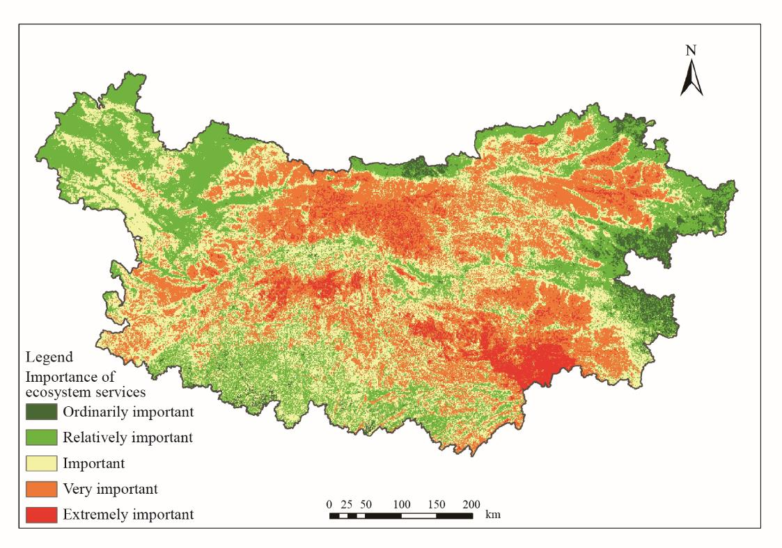
Fig. 1. Importance grading map of ecosystem services for the Qinba Mountain Area.
《4.2 Ecological sensitivity》
4.2 Ecological sensitivity
According to the sensitivity assessment indices presented in Table 1, an ecological sensitivity assessment map is derived for the Qinba Mountain Area using ArcGIS 10.2 (Fig. 2). Most parts of the Qinba Mountain Area are located in highly sensitive to extremely sensitive zones, with an area of approximately 2.117 × 10⁵ km2 and accounting for 68.96% of the study area. These zones are mainly distributed in the Qinling, Minshan, Micang, Daba, and Funiu Mountains, exhibiting complex terrain, favorable ecological environments, and abundant natural resources. Any disturbance or damage to these zones may adversely impact the ecological environment of the entire area because they are the core regions of ecological resources in the Qinba Mountain Area. Therefore, they are ecologically highly sensitive and should be given priority protection. Within the area, some ecologically insensitive, mildly sensitive, or moderately sensitive zones can be observed mainly in the flat basin regions, which is associated with the spatial distribution of the construction and agricultural lands. The ecological sensitivity decreases because of the impact of human activity.
《Fig. 2》

Fig. 2. Sensitivity grading map of ecosystem services for the Qinba Mountain Area.
《4.3 Regional ecological security pattern based on ecosystem services》
4.3 Regional ecological security pattern based on ecosystem services
4.3.1 Important ecological sources
The ecological sources of the Qinba Mountain Area can be obtained by comprehensively considering the importance of the ecosystem services and ecological sensitivity. After the superimposition of the ecosystem service importance and ecological sensitivity, the resulting spatial distribution of ecosystem importance was subjected to hotspot and coldspot identification using ArcGIS 10.2. Thus, the spatial distribution of high and low importance values for ecological protection could be observed in the study area (Fig. 3). Based on the identification results of the regional hotspots and coldspots, major eco-protection hotspots (with a confidence level of more than 90%) were selected as the candidate ecological sources to achieve the objective of ensuring maximum protection of the important ecological zones within the study area. After excluding the patches with an area of less than 5 km2 , the ecological source patches in the Qinba Mountain Area, having an area of 1.356 × 10⁵ km2 and accounting for 44.17% of the entire study area, were considered.
《Fig. 3》

Fig. 3. Importance value distribution map of ecological protection for the Qinba Mountain Area.
4.3.2 Ecological corridors
The ecological corridor, as the link between the ecological sources, acts as a carrier of energy and material. Further, it also denotes the key ecological land that should be protected for maintaining the continuity and connectivity of ecological flow, processes, and functions as well as energy within a region [24]. Establishing a continuous strip corridor is a vital measure to promote the connectivity of the fragmented landscapes or ecological patches [25]. However, the stepping stone corridor comprising small-patch eco-environments can offer temporary habitats for animal migration and dispersal because it contains certain food resources and shelter conditions. Thus, it is an important auxiliary measure to connect fragmented landscapes [26,27]. The corridor with minimum cumulative cost is built using the Cost Distance tool in ArcGIS 10.2 based on the ecological sources and resistance surfaces (resistance surfaces refer to the reciprocal of the ecosystem service importance). Ten river strip corridors are established to enhance the feasibility of ecological corridor construction and respect the current situation associated with seven national nature reserves related to the protection of aquatic organisms in the study area (Fig. 4). The river strip corridors are built on the basis of rivers above grade 4 within the area. Further, biological strip corridors are established along two biological channels of the Minshan Mountain–Qinling Mountains–Funiu Mountain and the Minshan Mountain–Micang Mountain–Daba Mountains (Fig. 4). This can be achieved by incorporating the current distribution trends associated with the first-class protected animals in the study area, including the distribution of golden snub-nosed monkeys in the Shennongjia and West Qinling regions [28], the distribution of forest musk deer, leopards, and giant salamanders in the Qinling and Daba mountains [29,30], and the primary distribution of giant panda habitats in the Qinling Mountains, with a severely fragmented feature [31]. Based on the overall distribution of nature reserves within the study area, 26 stepping stone corridors are designed between the strip corridors and the adjacent ecological sources. These stepping stone corridors, which are arranged based on the provincial and municipal nature reserves, are superb in eco-environment quality. Therefore, the migration and communication requirements of species can be achieved by exploiting the zones between the strip corridors.
《Fig. 4》

Fig. 4. Ecosystem security pattern for the Qinba Mountain Area.
The ecological security pattern of the Qinba Mountain Area comprises six important ecological sources, 12 key strip corridors, and 26 stepping stone corridors. The ecological sources are mainly distributed around the Minshan Mountain, Qinling Mountain, Funiu Mountain, southwestern Henan mountain regions, Micang Mountain, and Daba Mountains. These patches contain major nature reserves, which are characterized by a high proportion of ecological lands and favorable eco-environment quality. The strip corridors connecting the ecological sources are distributed along the river system. The biological corridors ensure the eco-environmental integrity of species in the east–west direction, and the river corridors ensure the coherence of the ecological processes and the continuity of ecological functions for the whole study area in the north–south direction.
《5 Conclusion》
5 Conclusion
Based on the superposition of 108 nature reserves with an ecological security pattern in the study area, more than 70% of the nature reserves are included within the scope of ecological sources. There are 54 national nature reserves in the Qinba Mountain Area. Apart from two geological nature reserves (Nanyang National Natural Reserve of Dinosaur Egg Fossils and Qinglongshan National Natural Reserve of Dinosaur Egg Fossils), more than 90% of the nature reserves exhibit an ecological security pattern when the geological remains, inland wetlands, forest ecology, wildlife, and other protection types are included. Furthermore, the main protection targets include water resources, wetland ecosystems, mountain forest ecosystems, and endemic rare species, including the giant panda, crested ibis, and golden snub-nosed monkey. The high consistency achieved in this study with respect to the objectives of species diversity, water conservation, and ecological sensitivity in case of ecological source identification suggests that the results obtained by establishing the ecological security pattern are reliable.
The main body of ecological security pattern is concentrated in the major mountain ranges (the Qinling, Funiu, Daba, Minshan, and Micang Mountains) and river valley regions within the study area, playing a crucial role in ensuring and supporting the ecological security of the Qinba Mountain Area. The important ecological sources and ecological corridors are the zones that need priority protection and ecological construction. The ecological security pattern of the Qinba Mountain Area, which has been established according to the importance of the ecosystem service functions, provides a strategy for regional spatial ecological planning by maintaining the status quo of the ecosystem services. Further, it provides the basis and support for identifying the importance of ecological protection and delineating the ecological red lines, which can provide evidence with respect to the planning and layout of national parks, regional ecological protection planning, and ecological civilization construction in the Qinba Mountain Area. In addition, it also helps the provinces and the cities in the area to completely consider the regionally important ecological spaces during planning and development, construct and restore the ecological spaces within the respective administrative units to enhance the supply of public ecological products, and establish ecological compensation mechanisms among provinces and cities. In future, we intend to investigate the manner in which the optimal width of the strip corridor and the minimum area of the stepping stone corridor can be determined. Furthermore, we intend to study the manner in which the relation between wildlife passages and highways can be appropriately understood.


 京公网安备 11010502051620号


