

《1. Introduction 》
1. Introduction
On 23 June 2020, the third geostationary Earth orbit satellite (GEO-3), the last satellite of the China’s BeiDou Navigation Satellite System (BDS)-3 space segment construction project, was successfully launched, marking the completion of the BDS global constellation deployment and indicating the successful completion of the BDS ‘‘three-step” development strategy. The positioning, navigation, and timing (PNT) service and special-feature services provided by the BDS have been widely used in key infrastructures of the national economy and defense security; they have also promoted a transformation of the production method and upgraded industrial infrastructure in China.
《2. BDS-3 overview》
2. BDS-3 overview
The BDS-3 is composed of a space segment (a navigation satellite constellation), a ground segment (including master measure and control stations, monitoring stations, and uplink stations), and a user segment (user terminals) [1]. The space segment constellation is the core component of the system. The BDS-3 hybrid constellation consists of three geostationary Earth orbit (GEO) satellites, three inclined geosynchronous orbit (IGSO) satellites, and 24 medium Earth orbit (MEO) satellites (often referred to as ‘‘3GEO + 3IGSO + 24MEO”; Fig. 1), which are based on the regional BDS-2 constellation. These satellites provide basic PNT service worldwide and special-feature services in China and surrounding areas.
With the design of a new navigation signal structure, improvements in the performance and measurement accuracy of spaceborne atomic clocks, the establishment of inter-satellite links, and the enhancement of its short-message report service capabilities, the BDS-3 has achieved global navigation signal coverage and performance improvement, as well as stable operation goals and compatibility and interoperability with other global navigation satellite systems (GNSSs). The principal characteristics and functions of the system are detailed below.
《Fig. 1》

Fig. 1. Structure of the BDS-3 constellation.
《2.1. Hybrid constellation services》
2.1. Hybrid constellation services
As mentioned earlier, the BDS-3 space segment consists of a combination of GEO, IGSO, and MEO satellites, for a total of 30 satellites [2]. The services provided by this hybrid constellation are distinct from those of other navigation satellite systems. The BDS-3 combines the advantages of navigation, positioning, and communication technology. Compared with other GNSSs, the BDS-3 emphasizes high-precision, short-message, and positioning reporting, and basic PNT services. Of the six types of satellite-based services that are provided (Table 1), the three global services are PNT (i.e., radio navigation satellite service (RNSS)), global shortmessage communication (GSMC), and international search and rescue (SAR). The three regional services (in China and surrounding areas) are satellite-based augmentation service (SBAS), precision point positioning (PPP), and regional short-message communication (RSMC) [3]. The services provided by BDS-3 better meet the needs of different users, and its technical solutions and system achievements have led the multifunctional aggregation trend of GNSS technologies.
《Table 1》
Table 1 Services provided by GNSSs.
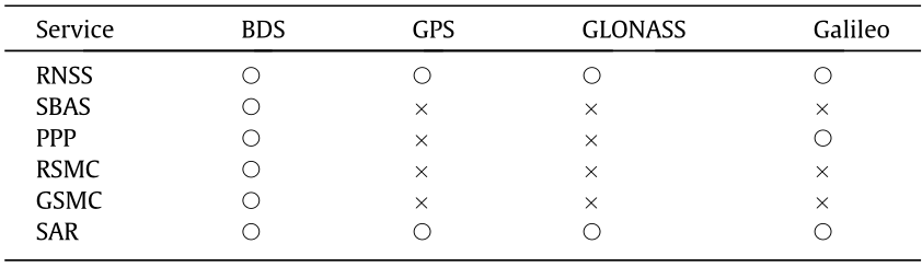
The  symbol marks available services and × represents unavailable services. RNSS: radio navigation satellite service; SBAS: Satellite-based augmentation service; PPP: precision point positioning; RSMC: regional short-message communication; GSMC: global short-message communication; SAR: international search and rescue.
Testing and application were implemented during the construction of BDS-3, and basic BDS-3 PNT service has been provided to global users since December 2018 [4]. GSMC and SAR services have been at full capacity since December 2019, and the SBAS, PPP, and RSMC services became available in 2020.
《2.2. The Internet of Everything on the space–time datum》
2.2. The Internet of Everything on the space–time datum
With the installation of a high-precision and high-stability time–frequency system on its satellites, the BDS-3 constellation can be used as a space–time datum infrastructure to provide global users with continuous, all-weather, and high-accuracy PNT services. The system has the unique advantages of uniformity, accuracy, ease of use, and low cost; it establishes and maintains a space–time datum for ground-based, sea-based, space-based, and low Earth orbit (LEO) spacecraft users; and it plays an important role in obtaining the time and location information of users or objects under a unified space–time reference. The system also provides a basis for the Internet of Everything and the Intelligence of Everything in an information-based society.
The BDS-3 is a perfect combination of space science and technology and space–time datum requirements. In the BDS-3, multiple satellites are distributed to form a constellation; their positions and orbits are accurately measured through ground stations within a unified time and coordinate system. These satellites become position and time navigation standard stations using radio navigation signals to transmit time and space reference information to users within the coverage area. According to statistics, more than 80% of the information data in today’s information-based society is related to position and time messages. The integration of the BDS with mobile communication, big data, artificial intelligence, and other technologies will provide more significant support and a greater boost to the intelligent era with the Internet of Everything.
《2.3. A world-class space infrastructure》
2.3. A world-class space infrastructure
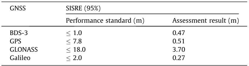
The signal-in-space (SIS) accuracy of the four major GNSSs was evaluated by the International GNSS Monitoring and Assessment System (iGMAS), which is composed of multiple global monitoring stations. The assessment results showed that the average SIS range error (SISRE) of the BDS-3 in 2020 was 0.47 m, which was better than those of GPS and GLONASS (Table 2). Thus, the BDS-3 can independently provide a navigation signal service at an internationally advanced level.
《Table 2》
Table 2 The SIS accuracy of four GNSSs.
The testing and measurement results of the BDS-3 in 2020 showed that the horizontal positioning accuracy of all frequency signals is better than 4 m. That of the smooth transition signal B1I (the BDS-2 signal) is about 3 m, and that of the new signal, B1C, is better than 2 m (Figs. 2 and 3). See the next section for a description of the B1I and B1C signals.
In the BDS-3 system, great importance is attached to international cooperation and coordination. With limited navigation signal frequency resources, advanced technologies are used on the BDS-3 satellites to improve and optimize navigation signals. A dedicated signal is broadcasted in the B1 frequency band in order to achieve compatibility and interoperability with other navigation satellite systems, including the GPS (the United States) and GLONASS (Russia). The BDS-3 enables global users to share highquality services provided by multiple GNSSs. By further improving the user experience, the system has made a great contribution to the integrative development of GNSSs. The test results show that, in comparison with the positioning service provided by a single GNSS system, the positioning service performance based on the joint use of four systems (BDS, GPS, GLONASS, and Galileo) is increased by more than 50%.
《Fig. 2》
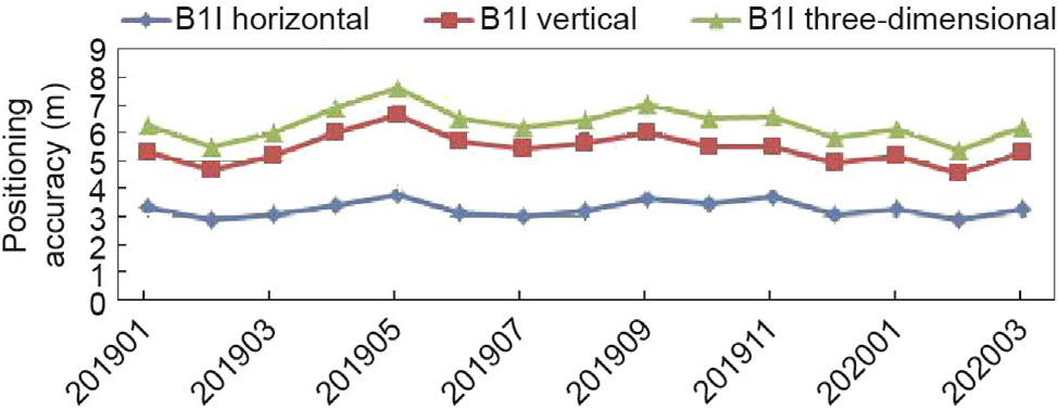
Fig. 2. Positioning accuracy of the smooth transition signal, B1I.
《Fig. 3》

Fig. 3. Positioning accuracy of the new signal, B1C.
《3. Major technological breakthroughs 》
3. Major technological breakthroughs
《3.1. Innovative navigation signal designs》
3.1. Innovative navigation signal designs
The navigation signal is the core carrier of GNSS design and service. As the frequency and bandwidth of navigation signals were primarily occupied by the earlier constructed GNSSs (i.e., GPS and GLONASS), the frequency resources available for the BDS navigation signal were extremely limited. The signal system design of the BDS-3 aims to improve user-oriented performance and function integration, achieve transition smoothly from the BDS-2 signal, and adhere to the requirements of independent innovation, compatibility, and interoperability. The system involves a new three-frequency navigation signal configuration (Fig. 4).
《Fig. 4》
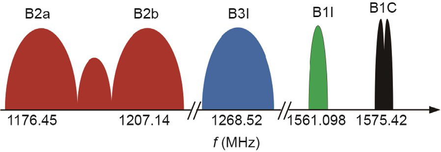
Fig. 4. BDS-3 open service navigation signals.
The BDS-3 broadcasts new global navigation signals and smooth transition signals (Table 3), such as B1I and B3I, to ensure the continued use of the BDS-2 user terminals [5]. In the B1 and B2 frequency bands of the BDS system, quadrature multiplexed binary offset carrier (QMBOC) and asymmetric constant envelope binary offset carrier (ACE-BOC) modulations are respectively adopted to ensure compatibility and interoperability with other GNSS signals while maintaining system independence. The system design adopts the constant envelope multiplexing technology of multi-carrier signals, which is characterized by sparse frequency domains and a constant time-domain envelope. This technology effectively utilizes non-continuous spectrum resources and improves the ranging accuracy and anti-interference ability of navigation signals. The navigation signal of the BDS-3 satellite has a flexible structure and diverse receiving methods.
《Table 3》
Table 3 BDS-3 services and signals.
《3.2. Development of a new inter-satellite link》
3.2. Development of a new inter-satellite link
GNSSs, such as GPS and Galileo, rely on the deployment of ground stations around the world to achieve satisfactory global PNT service performance. In response to problems such as nonglobal station deployment and short satellite observation arcs, BDS-3 innovatively introduces a technical solution that involves domestic ground stations plus inter-satellite links to build a GNSS. The inter-satellite links constantly provide satellite-to-satellite measurement data within the entire constellation and perform satellite precise orbit determination and time synchronization to achieve global navigation operation and to ensure uniform global system service performance.
With the installation of radio signal measurement and communication equipment on BDS-3 satellites, pseudo-range measurement and two-way communication between satellites are obtained, thereby achieving the goal of improving the accuracy of satellite orbit determination and time synchronization and supporting all-weather in-orbit management of all satellites. Through the inter-satellite links, the BDS-3 constellation system displays the significant features of an information network (Fig. 5).
《Fig. 5》

Fig. 5. Schematic diagram of the BDS-3 inter-satellite links.
The inter-satellite links on the BDS-3 satellites use Ka-band phased-array antenna technology and a time division half-duplex system. Based on the working condition of each satellite on each orbit in the hybrid constellation, the onboard integrated information processing and control unit controls the antenna signal beam direction of the spaceborne phased-array link with a network routing plan and link-building strategy in order to establish periodically changing inter-satellite links for satellite data transmission and precise ranging. The inter-satellite links adopted by the BDS-3 system achieve global-leading performance including a higher ranging accuracy, superior data-transmission capacity, and stronger anti-jamming capability than other systems. The in-orbit test results show that the orbit prediction accuracy of the BDS-3 MEO satellites improved from 0.4 to 0.15 m while using the intersatellite link; additionally, the clock offset prediction error was reduced from 3 to 1 ns, and the navigation constellation achieved one-station management capability.
《3.3. Continuous upgrading of the spaceborne atomic clock》
3.3. Continuous upgrading of the spaceborne atomic clock
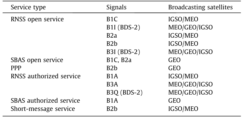
The spaceborne atomic clock generates time and frequency reference signals on the satellite and is an important basis for navigation satellites to transmit high-performance navigation signals. The performance of the clock directly determines PNT service accuracy. The BDS-3 satellites are equipped with a new generation of domestic rubidium clocks (Fig. 6(a)) with high integration, high performance, and reliability, which satisfy the new integration load conditions of the satellite platform. The stability of the clocks reach the international advanced 10–14 level.
To further improve the positioning, timing accuracy, and autonomous operation capability, the BDS-3 satellites are also equipped with domestic hydrogen atomic clocks (Fig. 6(b)). These clocks enable the satellites to achieve better frequency stability, frequency accuracy, and daily drift rate, as the daily stability of the hydrogen atomic clock has reached the 10–15 level.
The BDS-3 constellation fully utilizes the characteristics of these two types of atomic clocks. A hybrid clock configuration operates the spaceborne time–frequency system with high performance and reliability and the seamless switching of time–frequency signals; in this way, it significantly improves the time–frequency performance and service accuracy of the BDS-3 satellites.
《Fig. 6》
Fig. 6. Atomic clocks in the BDS-3: (a) spaceborne rubidium clock and (b) spaceborne hydrogen clock.
《3.4. Expansion of short-message communication capability》
3.4. Expansion of short-message communication capability
Short-message communication is the best service of the BDS navigation–communication integration design concept. The BDS3 further enhances the service capabilities of BDS-2 while inheriting its regional active technical system. The RSMC service in China and surrounding areas has smoothly transitioned to the BDS-3 and has ensured continuous use by BDS-2 terminals by optimizing the satellite antenna design and increasing the number of transponder channels and antenna beams to six (Fig. 7). Consequently, radio frequency (RF) signal power and service capability have been greatly improved.
《Fig. 7》
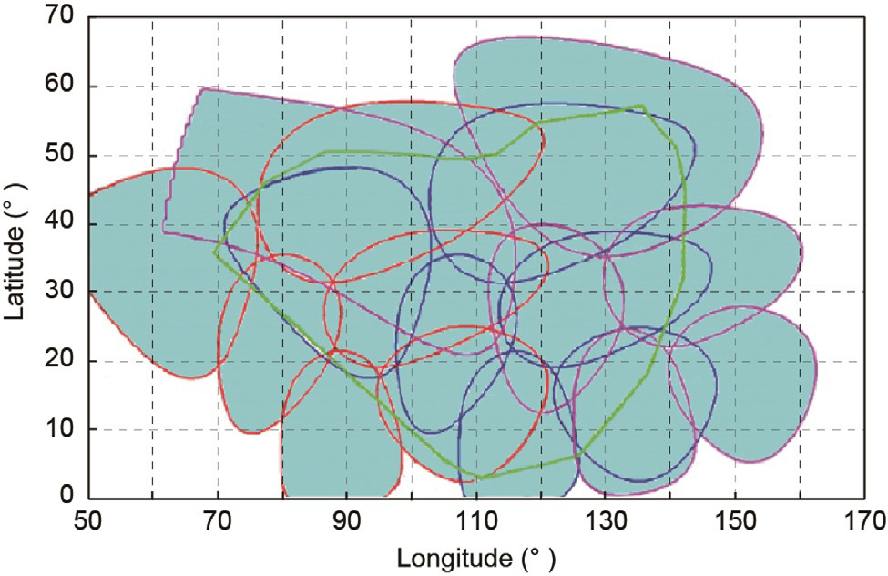
Fig. 7. Service coverage area of the regional short-message S-band signal.
Measures have been taken to improve the system, such as increasing the transmitted signal power and improving the signal design. These measures permit a smooth transition of the original user experience and increase the communication service capacity of the BDS-3 by ten times in comparison with BDS-2, up to more than ten million times per hour. The length of a single RSMC message is thus increased from 120 to 1000 Chinese characters, while the user transmission power is reduced to 1/10.
By configuring movable spot beams on three GEO satellites, the short-message service range has been expanded to the Indian and Pacific Oceans. In addition, the BDS-3 further extends its short message communication service to the world. The MEO satellites are equipped with a message communication receiver based on processing and retransmission to achieve dual coverage at a 15° elevation angle and single coverage at a 30° elevation angle. Through the BDS-3 global coverage and inter-satellite link, global users can receive services such as message communication, location reporting, and emergency SAR (Fig. 8).
《Fig. 8》

Fig. 8. Schematic diagram of the BDS-3 global short-message service.
《3.5. Batch development of satellites and domestic satellite technologies》
3.5. Batch development of satellites and domestic satellite technologies
The high-density batch-production capacity of navigation satellites has been a key factor in the rapid constellation deployment of BDS-3. The first domestic whole-trussed satellite platform (Fig. 9), which was independently developed by the BDS-3 satellite team, solved the problems of multi-MEO satellite launching and met the rapid deployment requirements. The satellite platform has reached an internationally advanced level in terms of satellite carrying efficiency and the weight ratio and power–mass ratio of the payload platform.
《Fig. 9》
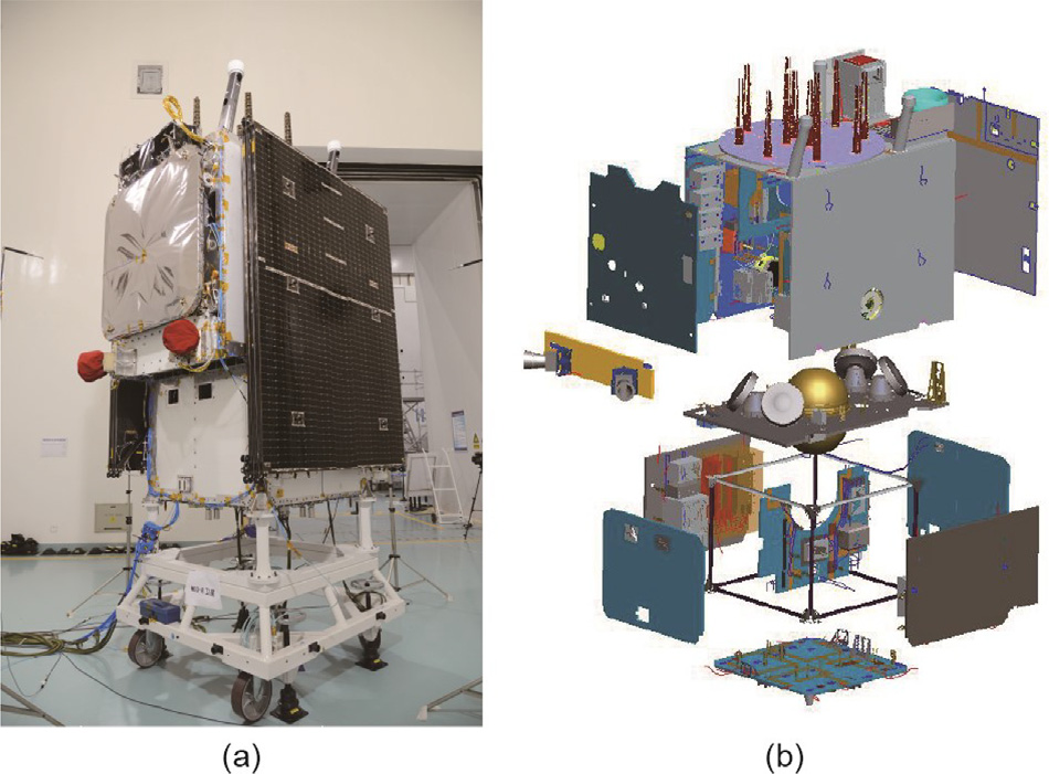
Fig. 9. A BDS-3 MEO satellite. (a) An MEO satellite; (b) a structural exploded view of the satellite.
In accordance with engineering construction and batch-project development management requirements, the BDS-3 satellite development team put forward new measures and methods for dynamic resource allocation, development process reengineering, batch-production technical status control, quality control, assembly, integration, and testing. In this way, they achieved the parallel assembly and testing of 12 satellites per year. This development capability entailed an unprecedented scale of satellite batch production and strongly supported the high-density launch of 30 satellites in the BDS-3 system within three years. BDS-3 construction was completed half a year ahead of schedule, creating a new ‘‘China speed” in the global history of navigation constellation deployment.
As the BDS is space infrastructure of national significance, the key technologies and core products of the BDS must be independently controlled. At the early design stage of BDS-3 satellite development, the requirements for domestic products and independent control were clearly prioritized, and the localized development, verification, and application of satellite devices were integrated. Adhering to the philosophy of original innovation and independent development, the system- and equipment-level satellite product developers achieved major breakthroughs in key technologies, such as the spaceborne atomic clock, the traveling wave tube amplifier, and the high-power microwave switch. The 100% localization of spaceborne equipment-level products and the autonomous control of core components were implemented in order to free China from dependence on other countries.
《4. Prospects for future BDS development》
4. Prospects for future BDS development
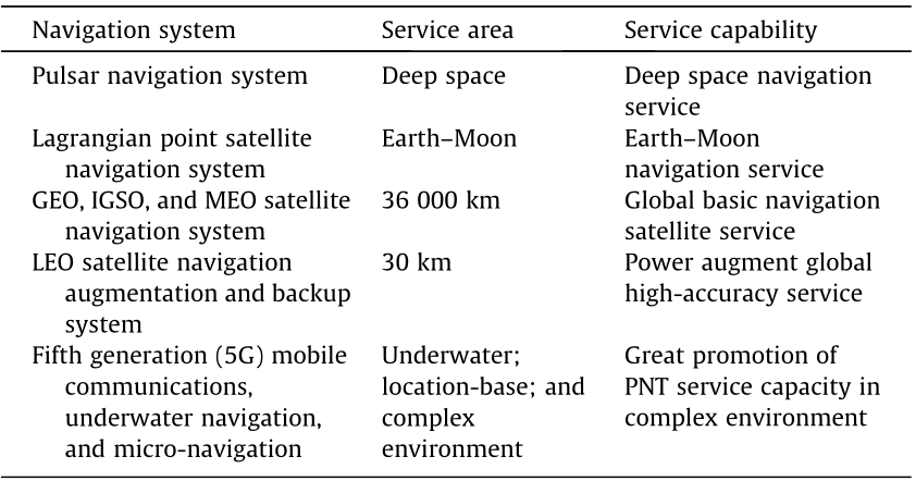
With the development of user requirements and modern science and technology, the capabilities and services of the BDS will be continuously improved and upgraded. Similar to other GNSSs, the BDS navigation signal, which is based on radio signal measurement and transmission technology, has inherent vulnerabilities and limitations. These include low landing power, poor penetration, and susceptibility to interference, especially in environments such as deep space, underwater, and indoors. Thus, the BDS team has embarked on the demonstration and research of the next-generation BDS. While fully utilizing the service capabilities of the space-based hybrid constellation navigation system, the BDS will be integrated with multiple navigation technologies to create a more accurate and credible space–time datum. A comprehensive PNT system will be developed to provide more robust space–time information support for national security and economic development in the following manner [6]. First, a more ubiquitous, integrated, and intelligent national PNT system will be built in accordance with the system integration development concept. Solutions with different PNT services will be provided according to different user scenarios in order to achieve threedimensional service coverage ranging from deep space to deep sea. Diversified service capabilities with positioning accuracies from the kilometer level to the decimeter and centimeter levels will be tailored to user needs for more ubiquitous, more accurate, and safer space–time information services (Table 4).
《Table 4》
Table 4 Structure of the national PNT system.
Second, the cornerstone role of the BDS will be further strengthened to create a more accurate, stronger, wider, and more intelligent BDS service capability:
• More accurate: space–time reference service;
• Stronger: navigation countermeasure services;
• Wider: navigation information services; and
• More intelligent: space-based cloud service.
An integrated space–time datum network and a navigation information service network will be constructed. Breakthroughs will be made in key technologies, such as the satellite-based space–time datum, intelligent satellite systems, and navigation information service networks. A hybrid constellation of high Earth orbit (HEO), MEO, and LEO satellites will be built to form a safe, reliable, efficient, and convenient integrated national PNT system with unified references and seamless coverage.
Third, supplement, backup, and augmentation systems will be built. By combining the existing BDS with the LEO communication constellation, an augmentation system based on the LEO communication constellation will be built to achieve global PNT backup service capability and to improve BDS service performance in complex environments. Through the integration of BDS and mobile 5G/6G communication technology, the weakness of indoor PNT service will be improved to achieve seamless indoor and outdoor positioning. By upgrading and building long-range land-based navigation systems, a backup of basic PNT capability will be established that will function under extreme conditions at sea. Underwater navigation systems can be deployed as needed to gradually fill the gaps in underwater capabilities. Space X-ray pulsar navigation technology should simultaneously be actively explored to provide PNT support for human deep-space exploration activities, and micro-PNT systems should be developed to achieve coordinated development with radio navigation.


 京公网安备 11010502051620号


