
2020, Volume 6, Issue 8
Engineering >> 2020, Volume 6, Issue 8 doi: 10.1016/j.eng.2020.06.012
Precise Three-Dimensional Deformation Retrieval in Large and Complex Deformation Areas via Integration of Offsets-Based Unwrapping and Improved Multiple-Aperture SAR Interferometry: Application to the 2016 Kumamoto Earthquake
Department of Geoinformatics, University of Seoul, Seoul 02504, Korea
Next Previous
Abstract
Conventional synthetic aperture radar (SAR) interferometry (InSAR) has been successfully used to precisely measure surface deformation in the line-of-sight (LOS) direction, while multiple-aperture SAR interferometry (MAI) has provided precise surface deformation in the along-track (AT) direction. Integration of the InSAR and MAI methods enables precise measurement of the two-dimensional (2D) deformation from an interferometric pair; recently, the integration of ascending and descending pairs has allowed the observation of precise three-dimensional (3D) deformation. Precise 3D deformation measurement has been applied to better understand geological events such as earthquakes and volcanic eruptions. The surface deformation related to the 2016 Kumamoto earthquake was large and complex near the fault line; hence, precise 3D deformation retrieval had not yet been attempted. The objectives of this study were to ① perform a feasibility test of precise 3D deformation retrieval in large and complex deformation areas through the integration of offset-based unwrapped and improved multiple-aperture SAR interferograms and ② observe the 3D deformation field related to the 2016 Kumamoto earthquake, even near the fault lines. Two ascending pairs and one descending the Advanced Land Observing Satellite-2 (ALOS-2) Phased Array-type L-band Synthetic Aperture Radar-2 (PALSAR-2) pair were used for the 3D deformation retrieval. Eleven in situ Global Positioning System (GPS) measurements were used to validate the 3D deformation measurement accuracy. The achieved accuracy was approximately 2.96, 3.75, and 2.86 cm in the east, north, and up directions, respectively. The results show the feasibility of precise 3D deformation measured through the integration of the improved methods, even in a case of large and complex deformation.
Keywords
Synthetic Aperture Radar (SAR) ; Conventional SAR interferometry (InSAR) ; Multiple-aperture SAR interferometry (MAI) ; ALOS2 PALSAR2 ; 3D deformation retrieval ; 2016 Kumamoto earthquake
Figures
Fig. 1

Fig. 2
Fig. 3
Fig. 4
Fig. 5

Fig. 6
Fig. 7
Fig. 8
Fig. 9
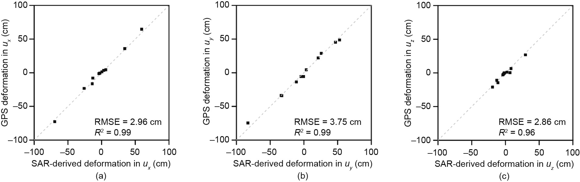
Fig. 10
References
[ 1 ] Biggs J, Amelung F, Gourmelen N, Dixon TH, Kim SW. InSAR observations of 2007 Tanzania rifting episode reveal mixed fault and dyke extension in an immature continental rift. Geophys J Int 2009;179(1):549–58. link1
[ 2 ] Wei M, Sandwell D, Fialko Y, Bilham R. Slip on faults in the Imperial Valley triggered by the 4 April 2010 Mw 7.2 El Mayor–Cucapah earthquake revealed by InSAR. Geophys Res Lett 2011;38(1):L01308. link1
[ 3 ] Jung HS, Hong SM. Mapping three-dimensional surface deformation caused by the 2010 Haiti earthquake using advanced satellite radar interferometry. PLoS ONE 2017;12(11):e0188286. link1
[ 4 ] Jo MJ, Jung HS, Yun SH. Retrieving precise three-dimensional deformation on the 2014 M6.0 South Napa earthquake by joint inversion of multi-sensor SAR. Sci Rep 2017;7(1):5485. link1
[ 5 ] Jo MJ, Jung HS, Chae SH. Advances in three-dimensional deformation mapping from satellite radar observations: application to the 2003 Bam earthquake. Geomatics Nat Hazards Risk 2018;9(1):678–90. link1
[ 6 ] Lee WJ, Lu Z, Jung HS, Ji L. Measurement of small co-seismic deformation field from multi-temporal SAR interferometry: application to the 19 September 2004 Huntoon Valley earthquake. Geomatics Nat Hazards Risk 2017;8 (2):1241–57. link1
[ 7 ] Lu Z, Dzurisin D, Biggs J, Wicks C Jr, McNutt S. Ground surface deformation patterns, magma supply, and magma storage at Okmok volcano, Alaska, from InSAR analysis: 1. intereruption deformation, 1997–2008. J Geophys Res 2010;115:B00B02. link1
[ 8 ] Jung HS, Lu Z, Won JS, Poland MP, Miklius A. Mapping three-dimensional surface deformation by combining multiple-aperture interferometry and conventional interferometry: application to the June 2007 eruption of Kilauea volcano, Hawaii. IEEE Geosci Remote Sens Lett 2011;8(1):34–8. link1
[ 9 ] Jo MJ, Jung HS, Won JS. Measurement of precise three-dimensional volcanic deformations via TerraSAR-X synthetic aperture radar interferometry. Remote Sens Environ 2017;192:228–37. link1
[10] Lee WJ, Lu Z, Jung HS, Park SC, Lee DK. Using a refined SBAS algorithm to determine surface deformation in the Long Valley caldera and its surroundings from 2003–2010. Korean J Remote Sens 2018;34(1):101–15. link1
[11] Qu F, Lu Z, Poland M, Freymueller J, Zhang Q, Jung HS. Post-eruptive inflation of Okmok volcano, Alaska, from InSAR, 2008–2014. Remote Sens 2015;7 (12):16778–94. link1
[12] Gray L. Using multiple RADARSAT InSAR pairs to estimate a full threedimensional solution for glacial ice movement. Geophys Res Lett 2011;38(5): L05502. link1
[13] Chae SH, Lee WJ, Jung HS, Zhang L. Ionospheric correction of L-band SAR offset measurements for the precise observation of glacier velocity variations on Novaya Zemlya. IEEE J Sel Top Appl Earth Obs Remote Sens 2017;10 (8):3591–603. link1
[14] Boncori JPM, Andersen ML, Dall J, Kusk A, Kamstra M, Andersen SB, et al. Intercomparison and validation of SAR-based ice velocity measurement techniques within the Greenland ice sheet CCI project. Remote Sens 2018;10 (6):929. link1
[15] Baek WK, Jung HS, Chae SH, Lee WJ. Two-dimensional velocity measurements of Uvêrsbreen glacier in Svalbard using TerraSAR-X offset tracking approach. Korean J Remote Sens 2018;34(3):495–506. link1
[16] Choi JK, Won JS, Lee S, Kim SW, Kim KD, Jung HS. Integration of a subsidence model and SAR interferometry for a coal mine subsidence hazard map in Taebaek, Korea. Int J Remote Sens 2011;32(23):8161–81. link1
[17] Zhang L, Ding X, Lu Z, Jung HS, Hu J, Feng G. A novel multi-temporal InSAR model for joint estimation of deformation rates and orbital errors. IEEE Trans Geosci Remote Sens 2014;52(6):3529–40. link1
[18] Choi JH, Kim SW. Comparison of observation performance of urban displacement using ALOS-1 L-band PALSAR and COSMO-SkyMed X-band SAR time series images. Korean J Remote Sens 2018;34(2):283–93. link1
[19] Baek WK, Jung HS, Jo MJ, Lee WJ, Zhang L. Ground subsidence observation of solid waste landfill park using multi-temporal radar interferometry. Int J Urban Sci 2019;23(3):406–21. link1
[20] Lu Z, Kwoun O. Radarsat-1 and ERS InSAR analysis over southeastern coastal Louisiana: implications for mapping water-level changes beneath swamp forests. IEEE Trans Geosci Remote Sens 2008;46(8):2167–84. link1
[21] Hong SH, Wdowinski S. A review on monitoring the Everglades wetlands in the southern Florida using space-based synthetic aperture radar (SAR) observations. Korean J Remote Sens 2017;33(4):377–90. link1
[22] Bechor NBD, Zebker HA. Measuring two-dimensional movements using a single InSAR pair. Geophys Res Lett 2006;33(16):L16311. link1
[23] Jung HS, Won JS, Kim SW. An improvement of the performance of multipleaperture SAR interferometry (MAI). IEEE Trans Geosci Remote Sens 2009;47 (8):2859–69. link1
[24] Jung HS, Lu Z, Zhang L. Feasibility of along-track displacement measurement from Sentinel-1 interferometric wide-swath mode. IEEE Trans Geosci Remote Sens 2013;51(1):573–8. link1
[25] Jung HS, Lee WJ, Zhang L. Theoretical accuracy of along-track displacement measurements from multiple-aperture interferometry (MAI). Sensors 2014;14 (9):17703–24. link1
[26] Jung HS, Yun SH, Jo MJ. An improvement of multiple-aperture SAR interferometry performance in the presence of complex and large line-of-sight deformation. IEEE J Sel Top Appl Earth Obs Remote Sens 2015;8(4):1743–52. link1
[27] Jung HS, Lu Z, Shepherd A, Wright T. Simulation of the SuperSAR multiazimuth synthetic aperture radar imaging system for precise measurement of three-dimensional Earth surface displacement. IEEE Trans Geosci Remote Sens 2015;53(11):6196–206. link1
[28] Jo MJ, Jung HS, Won JS, Poland MP, Miklius A, Lu Z. Measurement of slowmoving along-track displacement from an efficient multiple-aperture SAR interferometry (MAI) stacking. J Geod 2015;89(5):411–25. link1
[29] Jo MJ, Jung HS, Won JS, Lundgren P. Measurement of three-dimensional surface deformation by COSMO-SkyMed X-band radar interferometry: application to the March 2011 Kamoamoa fissure eruption, Kılauea volcano, Hawai’i. Remote Sens Environ 2015;169:176–91. link1
[30] Jo MJ, Jung HS, Won JS. Detecting the source location of recent summit inflation via three-dimensional InSAR observation of Kılauea volcano. Remote Sens 2015;7(11):14386–402. link1
[31] Morishita Y, Kobayashi T, Yarai H. Three-dimensional deformation mapping of a dike intrusion event in Sakurajima in 2015 by exploiting the right- and leftlooking ALOS-2 InSAR. Geophys Res Lett 2016;43(9):4197–204. link1
[32] Hu J, Ding XL, Zhang L, Sun Q, Li ZW, Zhu JJ, et al. Estimation of 3-D surface displacement based on InSAR and deformation modeling. IEEE Trans Geosci Remote Sens 2017;55(4):2007–16. link1
[33] Hu J, Li ZW, Ding XL, Zhu JJ, Zhang L, Sun Q. 3D coseismic displacement of 2010 Darfield, New Zealand earthquake estimated from multi-aperture InSAR and D-InSAR measurements. J Geod 2012;86(11):1029–41. link1
[34] Boncori JPM, Papoutsis I, Pezzo G, Tolomei C, Atzori S, Ganas A, et al. The February 2014 Cephalonia earthquake (Greece): 3D deformation field and source modeling from multiple SAR techniques. Seismol Res Lett 2014;86(1):1–14. link1
[35] Wang X, Liu G, Yu B, Dai K, Zhang R, Chen Q, et al. 3D coseismic deformations and source parameters of the 2010 Yushu earthquake (China) inferred from DInSAR and multiple-aperture InSAR measurements. Remote Sens Environ 2014;152:174–89. link1
[36] Wang X, Liu G, Yu B, Dai K, Zhang R, Ma D, et al. An integrated method based on DInSAR, MAI and displacement gradient tensor for mapping the 3D coseismic deformation field related to the 2011 Tarlay earthquake (Myanmar). Remote Sens Environ 2015;170:388–404. link1
[37] Grandin R, Klein E, Métois M, Vigny C. Three-dimensional displacement field of the 2015 Mw 8.3 Illapel earthquake (Chile) from across- and along-track Sentinel-1 TOPS interferometry. Geophys Res Lett 2016;43 (6):2552–61. link1
[38] Hu J, Li ZW, Li J, Zhang L, Ding XL, Zhu JJ, et al. 3-D movement mapping of the alpine glacier in Qinghai–Tibetan Plateau by integrating D-InSAR, MAI and offset-tracking: case study of the Dongkemadi glacier. Global Planet Change 2014;118:62–8. link1
[39] Gourmelen N, Kim SW, Shepherd A, Park JW, Sundal AV, Björnsson H, et al. Ice velocity determined using conventional and multiple-aperture InSAR. Earth Planet Sci Lett 2011;307(1–2):156–60. link1
[40] Himematsu Y, Furuya M. Fault source model for the 2016 Kumamoto earthquake sequence based on ALOS-2/PALSAR-2 pixel-offset data: evidence for dynamic slip partitioning. Earth Planets Space 2016;68(1):169. link1
[41] Baek WK, Jung HS, Chae SH. Feasibility of ALOS2 PALSAR2 offset-based phase unwrapping of SAR interferogram in large and complex surface deformations. IEEE Access 2018;6:45951–60. link1
[42] Chae SH, Lee WJ, Baek WK, Jung HS. An improvement of the performance of SAR offset tracking approach to measure optimal surface displacements. IEEE Access 2019;7:131627–37. link1
[43] Wright TJ, Parsons BE, Lu Z. Toward mapping surface deformation in three dimensions using InSAR. Geophys Res Lett 2004;31(1):L01607. link1
[44] Baek WK, Jung HS, Chae SH. Precise three-dimensional mapping of the 2016 Kumamoto earthquake through the integration of SAR interferometry and offset tracking. In: Proceedings of the 2017 IEEE International Geoscience and Remote Sensing Symposium; 2017 Jul 23–28; Fort Worth, TX, USA. New York: IEEE; 2017. p. 3822–3. link1
[45] Costantini M. A novel phase unwrapping method based on network programming. IEEE Trans Geosci Remote Sens 1998;36(3):813–21. link1
[46] Baek WK, Jung HS. Precise measurements of the along-track surface deformation related to the 2016 Kumamoto earthquakes via ionospheric correction of multiple-aperture SAR interferograms. Korean J Remote Sens 2018;34(6):1489–501. link1
[47] Lee WJ, Jung HS, Chae SH, Baek WK. Enhancement of ionospheric correction method based on multiple aperture interferometry. Korean J Remote Sens 2015;31(2):101–10. link1
[48] Zebker HA, Villasenor J. Decorrelation in interferometric radar echoes. IEEE Trans Geosci Remote Sens 1992;30(5):950–9. link1


 京公网安备 11010502051620号


