

《1. Introduction》
1. Introduction
The initial design of the Three Gorges Project (TGP) planned for three phases in the impoundment of its reservoir: the power generation period, with the water retained by a cofferdam; a preliminary operation period; and then a normal operation period. In 2003, the Three Gorges Reservoir was impounded to elevation (El.) 135 m, and power generation began with the water being retained by a cofferdam. In 2007, the reservoir was impounded to El. 156 m, and preliminary operations began. By 2009, as the main hydraulic structures were completed, the reservoir was fit to be impounded to its normal level of El. 175 m. However, it was still kept at the pool level during the preliminary period. Based on considerations of the resettlement progress, observed results of sedimentation at the reservoir tail area, the influence of sedimentation on Chongqing Port, and so forth, the duration of the preliminary operation period was determined at six years. Subsequently, in 2013, the Three Gorges Reservoir was impounded to its design pool level of El. 175 m; hence, the normal operation period began.
Preparations for the construction of the TGP began in 1993, the work commenced in December 1994, and the main river was closed on November 6, 1997. In 1998, construction of the dam and powerhouse on the left bank began. In October 2002, water passed through the diversion bottom outlets at the flood-sluicing dam, and on November 6 of the same year, the open diversion channel was completed; the flood-sluicing dam, the powerhouse, and the non-overflow dam section on the left bank and the head bay at the ship lift were completed and began retaining water. In June 2003, the reservoir was impounded to El. 135 m; in July, the first batch of generating units in the left powerhouse began generating power and the dual-line five-step continuous shiplock began operation. In 2004, construction of the dam and powerhouse on the right bank began, and by 2005, all 14 generating units in the left powerhouse commenced operation. In June 2006, the dam section on the right bank was concreted up to El. 185 m and the upstream roller-compacted concrete (RCC) cofferdam was demolished by blasting; thus, the whole dam began retaining water. In October, the reservoir was impounded to El. 156 m, marking the start of the preliminary operation period one year ahead of schedule. In 2007, the seven generating units in the powerhouse on the right bank began operation. In August 2008, the dam, powerhouse, and dual-line five-step continuous shiplock were all completed; the resettlement of counties and towns was completed; and programs on resettlement, the reservoir area clear-up, geological hazard control, water pollution control, ecological environmental protection, and the preservation of cultural relics were all finished and approved by relevant authorities. At this point, the reservoir was ready to reach its normal pool level of El. 175 m. Approved by the TGP Construction Commission of the State Council, the reservoir began to tentatively impound to El. 175 m at the end of the 2008 flood season, marking the shift from its operation at an El. 156 m pool level to its trial operation at El. 175 m.
《2. Changes in hydrological regime in the upper Yangtze River and the optimized operation of the Three Gorges Reservoir》
2. Changes in hydrological regime in the upper Yangtze River and the optimized operation of the Three Gorges Reservoir
《2.1. Flood characteristics at the Three Gorges Project (TGP)’s damsite》
2.1. Flood characteristics at the Three Gorges Project (TGP)’s damsite
Flooding at the TGP’s damsite consists of floods from the Jinsha River (i.e., the upper trunkstream of the Yangtze River) and various tributaries. Major floods upstream of the damsite are caused by extensive and heavy rainfall in the upper regions of the Yangtze River, mainly from July to September. Since the Minjiang, Tuojiang, and Jialingjiang Rivers (as shown in Fig. 1) at the northern banks of the Yangtze River flow in a north-to-south direction through the rainstorm-prone area in western Sichuan Province and the Daba Mountain, the river flow and the rainfall movement synchronize. The tributary floods meet with the floods from the upper trunkstream and the interval flood from the trunkstream, thereby forming a major flood in the upper trunkstream. A flood at the damsite is considered in light of the maximum peak discharge (71 100 m3·s-1) observed at the Yichang Hydrometrical Station since 1877, with an empirical maximum peak discharge of 105 000 m3·s-1. The dam is designed according to a 1000 year frequency flood discharge of 98 800 m3·s-1 with its corresponding design flood level of El. 175 m, and checked against a flood discharge of 124 300 m3·s-1 (i.e., a 10000 year frequency flood discharge of 113 000 m3·s-1 plus its 10% flood discharge), with its corresponding checked flood level of El. 180.4 m.
《2.2. Changes in hydrological regime in the upper Yangtze River》
2.2. Changes in hydrological regime in the upper Yangtze River
Hydrometrical data observed at the Yichang Hydrometrical Station are used as preliminary design values for the TGP, with an annual average runoff of 4.51 × 10¹¹ m3 and an annual average sediment load of 5.21 × 10⁸ t [1]. Since the 1990s, runoff reduction from the upper Yangtze River has been limited and affected by rainfall change; while due to the efforts of sediment retention by hydro projects, sediment reduction by soil and water conservation, and river sand-mining, incoming sediment was prominently decreased (as shown in Table 1).
The reduction of incoming sediment into the reservoir is beneficial to its long-term operation. From 2003 to 2015, the annual average runoff at the damsite was 4.003 × 10¹¹ m3, which reduced by 5.07 × 10¹⁰ m3 (11.24%) when compared to its preliminary design value. The seasonal change in upstream runoff is similar to that of rainfall, and is unevenly distributed within a year, i.e., runoff during the flood season from June to October accounts for 70%‒75% of the annual total. Over the past 20 years, the runoff during flood season, and in October to November, has been lower than the preliminary design value, and it increased from December to May of the following year [2].
《2.3. Preliminary operation mode for the TGP》
2.3. Preliminary operation mode for the TGP
The preliminary operation mode designed for the TGP is as follows. During every flood season from mid-June to late September, the reservoir is operated at the flood control level of El. 145 m. When the level rises to El. 145 m, the flow discharged from the reservoir is 55 000 m3·s-1, so as to ensure that the discharge at the Zhicheng Hydrometrical Station of the Jingjiang River reach does not exceed 56 700 m3·s-1. In the case of a flood with a discharge of less than 55 000 m3·s-1, water is completely discharged down to El. 145 m. If a flood has a discharge of more than 55 000 m3·s-1, flood control operation must be conducted for the downstream reach; that is, the reservoir impounds this flood and controls the discharged flow. As the impounded flood will cause the water level to rise, once the flood process recedes, the water level must be lowered to El. 145 m again for the purpose of controlling subsequent floods. The operation mode of “storing clear water and discharging muddy water” is adopted for the Three Gorges Reservoir; that is, the reservoir impounds water after the flood season (early October) so as to scour sediment in the Chongqing reach at the tail area of the Three Gorges Reservoir. Considering the need for navigation in the downstream reach, the minimum flow discharged from the reservoir during impoundment is required to be no less than 53 000-64 600 m3·s-1, corresponding to the firm output of the Three Gorges powerhouse; then the water level gradually rises up to El. 175 m. During the low-water season, it is generally operated at a higher water level in order to allow for power generation and navigation in the reservoir area. In order to meet flood control needs, the water level is required to be lowered down to El. 145 m at the end of early June before the flood season. During a flood season, the flood control operation is conducted in a flood control compensation mode for the Jingjiang River reach, increasing the flood control standard there from controlling a 10 year frequency flood to controlling a 100 year frequency flood. In other words, in the case of a 100 year frequency flood with a flood discharge of 83 700 m3·s-1 from the upper Yangtze River, the maximum discharge at Zhicheng Hydrometrical Station can be controlled at 56 700 m3·s-1 through the TGP’s flood regulation. If a flood with a return period of over 100 or 1000 years occurs (including a flood similar to the 1870 extraordinary flood), the discharge at Zhicheng Hydrometrical Station can be controlled at less than 80 000 m3·s-1. In combination with the operation of flood storage and detention areas, this discharge can guarantee flood-flowing safety in the Jingjiang River reach, hence preventing the occurrence of a devastating disaster caused by breaching in main levees along the two sides [3].
《Fig. 1》
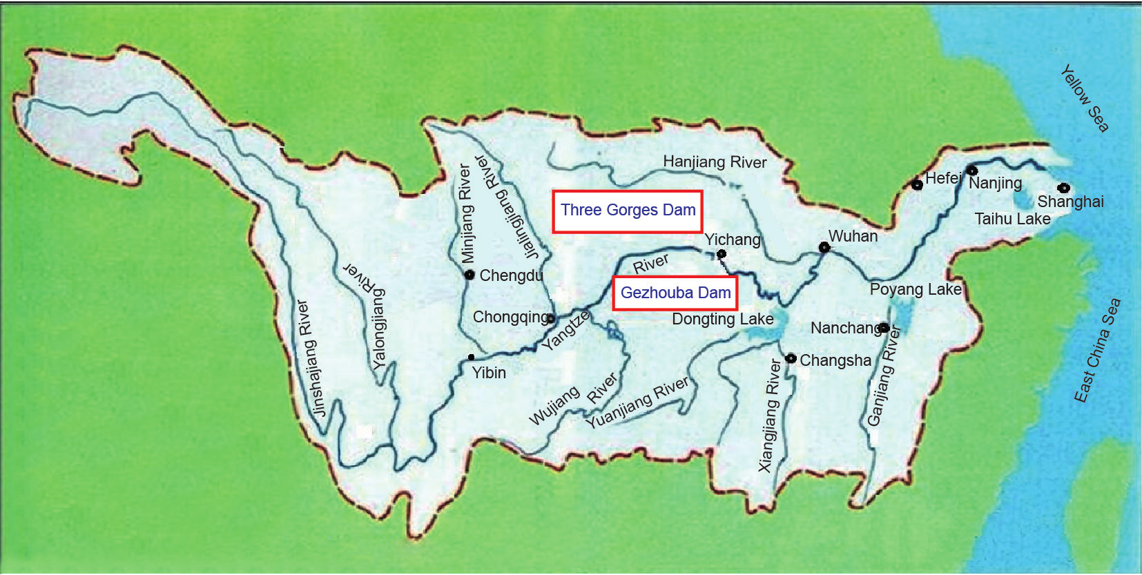
Fig.1 A plan map for the comprehensive utilization of the Yangtze River Basin.
《Table 1》
Table 1
Change in runoff and sediment load at the Three Gorges Project (TGP) damsite and flowing into the Three Gorges Reservoir.

Note: Cuntan and Wulong Hydrometrical Stations represent the site flowing into the Three Gorges Reservoir.
《2.4. Flood control and impoundment operations during the tentative impoundment operation period》
2.4. Flood control and impoundment operations during the tentative impoundment operation period
2.4.1. Flood control operation for the Three Gorges Reservoir and the Chenglingji reach
An analysis of flood data measured in the upper Yangtze River for the past 20 years indicates that the maximum peak discharge during this period was 63 300 m3·s-1 at Yichang Hydrometrical Station—smaller than the discharge of a 10 year frequency flood. In the case of a flood similar to the 1998 flood, if the TGP is operated in terms of flood control compensation for the Chenglingji reach, the reservoir would impound water with a flood volume of 3 × 10⁹ m3. In such a case, most of the flood control storage capacity would still not be utilized, although the flood control situation in the downstream Chenglingji reach (450 km from the damsite) would be tense. It is evident that the flood control effect of the TGP is not fully used. Therefore, during the trial impoundment period of the Three Gorges Reservoir, with the approval of competent authorities in October 2009, the TGP’s flood control operation scheme was optimized. The flood control operation of the Three Gorges Reservoir and the flood control compensation operation for the Chenglingji reach were both considered (Table 2).
2.4.2. Operation for detaining medium and small floods during flood season
The compensation operation for flood control of the Jingjiang River reach sets the target water level at Shashi Hydrometrical Station at no higher than El. 44.5 m, and the flood discharge from the Three Gorges Reservoir at more than 55 000 m3·s-1. When the flood discharge is between 45 000-55 000 m3·s-1, the flow discharged from the Three Gorges Reservoir will make the water level at Shashi Hydrometrical Station exceed its warning water level, thereby causing the water level along the middle Yangtze River to correspondingly be higher than the warning water level. There is a 30 000 km long levee along the middle and lower Yangtze River. The main part of the levee is about 3900 km long, and all of the levee is built on a Quaternary alluvial plain, where soils in the levee are badly bonded. When the water level rises, dangerous emergencies can easily happen, including leakage within the levee and piping through the levee base. During a flood season, when the water level rises up to its warning level, a considerable amount of manpower and material resources are used to check potential levee dangers. According to statistics, the water level in the Jingjiang River reach has exceeded its warning level more than three times in one decade. Small and medium floods of less than 55 000m3·s-1 are impounded by adopting the TGP’s flood control capacity, which can reduce the flood control pressure on the middle and lower Yangtze River. Considering that the flood composition in the Three Gorges Reservoir is complicated, methods for detaining small and medium floods will increase the probability of exceeding its flood level limit and the risk of flood control. Therefore, methods for detaining said floods should be managed according to the following principles: keeping the TGP’s flood control standard uncompromised; and not adding flood control pressure onto the lower Yangtze River. Based on the principles, the water level in the Three Gorges Reservoir is pre-discharged down to its flood level limit before a major flood flows into the Three Gorges Reservoir. It is controlled regardless of the flood control situation, with actual inflows and forecasting results. If it is necessary for the Three Gorges Reservoir to conduct a flood control compensation operation for the Jingjiang River and Chenglingji reaches, it can carry out the operation for detaining small and medium floods and set the necessary conditions for starting a flood detention operation. During the flood season in 2009-2015, flood operation for detaining small and medium floods was carried out, reducing the flood control pressure on the Jingjiang River reach and the Chenglingji area, making use of some flood resources to increase power generation benefits, and preventing economic loss caused by ships passing through the shiplock for a long time and by limiting ships’ navigation due to large flood discharging—thus obtaining excellent economic and social benefits. During the operation for detaining small and medium floods, the flow discharged during every flood season is less than 45 000 m3·s-1 and river channels in the Jingjiang River reach to release the flood, and in order to prevent shrinkage and degradation of river channels [4].
《Table 2 》
Table 2
Flood control operation mode for the TGP’s optimized operation.

2.4.3. Operation of impoundment from the late flood season
Over the past 20 years, the monthly average discharges in every September and October at Yichang Hydrometrical Station are 23 100 m3·s-1 and 14 600 m3·s-1, respectively—11.2% and 22.3% smaller than the preliminary design values. As the Three Gorges Reservoir is a quarterly-regulated reservoir, if it begins to impound in early October according to its initial design scheme, it will not impound up to El. 175 m in most years, which will seriously affect the full use of the TGP’s integrated benefits. Therefore, during its trial impoundment in 2008, water was impounded ahead of schedule in late September, and the starting impounded water level was determined at El. 145.3 m. Thereafter, water was impounded ahead of schedule on September 10-15 every year. The starting impounded water level is at its actual flood control operation level in an earlier stage, and water is stored up to about El. 162 m until late September. Flow discharged in September is kept at 10 000-8000 m3·s-1, and flow discharged in October is controlled at no less than 8000-6500 m3·s-1; water is impounded up to El. 175 m from late October to early November. During impoundment, if a major flood from the upper Yangtze River occurs and inflow into the Three Gorges Reservoir is more than 30 000 m3·s-1, impoundment action pauses and is operated according to the flood control requirement. Table 3 shows impoundment data from every year during the TGP’s trial impoundment and operation at El. 175 m.
《2.5. Water resources regulation and ecological operation during the tentative impoundment period》
2.5. Water resources regulation and ecological operation during the tentative impoundment period
2.5.1. Water resources regulation
During the TGP’s tentative impoundment and operation, in the event of a rapid drawdown of the water level in the trunkstream of the middle and lower Yangtze River and Dongting and Poyang Lakes, domestic water supply for urban and rural residents in the middle and lower reach regions, and household, production, and ecological water needs were prioritized. During the impoundment in 2009, a serious drought occurred in the middle and lower regions. In order to relieve the drought, after the water was impounded to El. 171.43 m, the water impoundment was stopped and the flow discharge was increased. During the drawdown period of the water level, the flow discharged was adjusted in light of requirements for water supply, navigation, water ecology, the environment, and power generation, and was controlled at no less than 6000 m3·s-1.
2.5.2. Ecological operation
In 2011, ecological operation trials began with the TGP for breeding four aquacultured fish species (black carp, grass carp, silver carp, and bighead carp). During the breeding period of the four fish species from late May to mid-June, the water temperature in the river course downstream of the damsite was higher than 18 ºC. In combination with requirements for emptying the storage capacity, and in accordance with the upstream water regime, 1-2 rising processes (lasting for about 10 days) were completed throughout the operation. A discharge of 11 000 m3·s-1 in the Yichang Hydrometrical Station was used as its initial discharge; the discharge was increased by 8000 m3·s-1 within six days, and finally increased to 19 000 m3·s-1, with an average daily rising amplitude of the water level of no less than 0.4 m. Monitoring results for an ecological operation test show that it promoted the breeding of the four aquacultured fish species, and increased the amount of eggs spawned during the operation period.
From February 21 to March 3, 2014, the TGP was utilized to conduct a “desalinization” operation, and the daily average flow discharged from the Three Gorges Reservoir was increased from 6000 m3·s-1 to 7000 m3·s-1, with a total added discharged flow of 1.007 × 10⁹ m3. To a certain extent, this operation mitigated the serious impact caused by salty tide intrusion upstream, and simultaneously relieved the water shortages in the middle and lower Yangtze River.
《2.6. Measures for detaining small and medium floods, impoundment since the late flood season, and reducing sedimentation in the reservoir》
2.6. Measures for detaining small and medium floods, impoundment since the late flood season, and reducing sedimentation in the reservoir
During the flood season, when the operation for detaining small and medium floods is conducted, the higher water level reduces its sediment delivery ratio; hence, the reservoir sedimentation rises. Advancing the impoundment to September 10 in the late flood season affects the sediment scouring (flowing) in rivercourses of fluctuating backwater at the tail of the Three Gorges Reservoir, and somewhat increases sedimentation in this reach. Due to a great decrease of sediment into the reservoir, observed data show that from June 2003 to December 2015, 1.6034 × 10⁹ t of sediment was deposited in the reservoir with an annual average sedimentation of 1.28 × 10⁸ t, accounting for only 38% of the predicted result. From 2003 to 2015, the annual sediment delivery ratio was 24.2%, less than its predicted value in the preliminary design, thereby increasing sedimentation in the Three Gorges Reservoir [5]. Measured hydrological data from the Bureau of Hydrology, Changjiang Water Resources Commission indicate that in the case of a major flood, it takes the flood peak 18-30 h to flow from the Cuntan Hydrometrical Station to the damsite, and three to seven days for the sediment peak. In July 2012, experiments were carried out with real-time monitoring and forecasting to reduce sedimentation into the reservoir. While the flood peak reduction was operated, the time difference between the flood peak propagation and the sediment peak propagation was utilized. First, the sediment delivery operation was carried out by controlling the discharged flow to reduce the flood peak during the rising period, and the discharged flow was increased to scour sediment during the recession period. This operation increased the sediment delivery ratio in July to 28%, resulting in a better sediment scouring effect and breaking through the conventional operational mode of discharging muddy water to the reservoir. In order to solve sediment scouring (and/or flowing) problems in the reach of Chongqing main urban area at the tail of the reservoir, two scouring tests were conducted in May 7-24 2012 and May 13-20, 2013. The water level at the reservoir was lowered from El. 161.92 m down to El. 154.5 m, and from El. 160.16 m down to El. 155.97 m; the drawdown was 7.42 m and 4.19 m, respectively, with a daily mean drawdown amplitude of 0.41 m and 0.52 m. This resulted in the terminal of backwater in the reservoir moving from the reach near Jiulongpo (625 km from the damsite) in the Chongqing main urban area down to the channel around Changshou District, downstream of the Tongluo Gorge (535 km from the damsite). During the drawdown period of the reservoir water level, the reach at the tail of the Three Gorges Reservoir was scoured streamwise. The scouring sediment in the reach from Dadukou District to Fuling District of Chongqing Municipality (including the 169 km long Jialingjiang River reach shown in Fig. 2) is 2.41 × 10⁶ m3 and 4.413 × 10⁶ m3. Sedimentation operation practices at the tail of the Three Gorges Reservoir indicate that in May of every year, in combination with lowering the reservoir level, sedimentation operations at the tail of the Three Gorges Reservoir can scour sediment deposited at the tail of the Three Gorges Reservoir downstream into the river channel below El. 145 m—thus solving sediment scouring in the reach of the Chongqing main urban area, which was influenced by the reservoir’s impoundment ahead of the late flood season. In combination with the simultaneous sediment peak scouring operation, this opens up a new way for the Three Gorges Reservoir to operate by “storing clear water and discharging muddy water.”
《Table 3》
Table 3
A summary of impoundment data from every year during the TGP’s trial impoundment and operation at El. 175 m.

《3. Resettlement and ecological environmental protection in the reservoir area》
3. Resettlement and ecological environmental protection in the reservoir area
《3.1. Resettlement in the reservoir area》
3.1. Resettlement in the reservoir area
A total of 1 296 400 residents have been relocated in the Three Gorges Reservoir Area, including 550 700 rural relocatees (with 196 200 residents moving out of the reservoir area). Two cities, 10 counties, and 106 towns were relocated, and 745 700 people were resettled, including those from industrial and mining establishments, with a relocated area of 71 427 300 m2. A total of 1128 protection works for cultural relic sites were put in place, including 364 surface relic sites and 764 underground relic sites, with an excavation area of 1 753 800 m2. A significant number of nationally important historical relics have been conserved and protected, and a large quantity of material data was kept. Rebuilding and relocation tasks of special projects in resettlement areas such as roads, bridges, ports, wharfs, water conservancy and power facilities, telecommunication lines, and radio and television have been completed. Living conditions, infrastructure, and public service facilities in the relocated establishments have undergone significant improvement; work start-overs for the resettled are guaranteed, and supportive measures show positive effects. Specially rebuilt relocation projects have fully restored the original functions, and are more reasonable in layout, greater in scale and grade, and better in function and effect than the previous settlements, guaranteeing the resettlement of residents as well as the demand for economic and social development in the reservoir area. These projects have stood the test of the reservoir’s operation at El. 175 m, and have established a generally stable and harmonious society in the reservoir area.
《3.2. Control of geological disasters in the reservoir area》
3.2. Control of geological disasters in the reservoir area
The Three Gorges Reservoir Area is historically prone to geological disasters. After the construction of the TGP began, the national government set up a special fund to take structural protection measures against geological disasters in the reservoir area. Structural treatment of 428 landslides and 302 unstable reservoir banks has eliminated harm from collapses and landslides to relocated towns and establishments for rural relocatees; alleviated hidden dangers caused by the slipping of landslides down into the river channel; prevented harm from geological disasters to ports, wharfs, and roads; and enhanced navigation safety. A total of 3049 monitoring points for geological disasters in the reservoir area were arranged and 525 relocation projects for evading geological disasters were conducted, greatly improving the geological environment in the reservoir area, increasing safety regarding people’s lives and properties in the reservoir area, and securing navigation safety in the Yangtze River. Since the Three Gorges Reservoir was impounded in June 2003, and specifically since the trial impoundment at El. 175 m in 2008, water has been impounded up to El. 175 m for nine years in a row. The frequency of landslides has tended to decrease with time, indicating that geological disasters caused by reservoir impoundment have shifted from frequent occurrences to a plateau of lower risk. Since the establishment of the monitoring and early warning network for geological disasters covering the whole reservoir area, this network has improved its early warning ability, survived from geological disasters induced by 100 year rarely occurring storm rains in 2007 and 2014, successfully given early warning and dealt with over 400 geological disasters, and effectively avoided any casualties. The control of geological disasters in the Three Gorges Reservoir Area has assured the safety of relocated towns and establishments for rural residents, and has verified the validity of the idea of “prevention top, necessary monitoring, hedging and relocating first, emphasis on project treatment, urban and rural residential areas” for controlling geological disasters.
《Fig. 2》
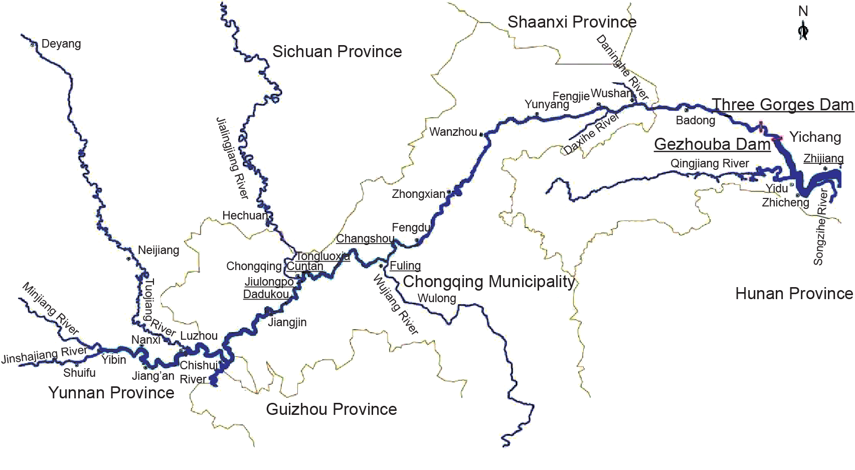
Fig.2 The Yangtze trunkstream and main tributaries upstream of the Three Gorges Dam.
《3.3. Earthquakes in the reservoir area》
3.3. Earthquakes in the reservoir area
The TGP is situated in a crystalline basement zone of the Huangling anticline core—a relatively stable land mass with a low seismic activity level and a weak seismic environment. No destructive earthquakes around the damsite, reservoir area, or the 10 counties and cities nearby have been recorded in history. Two fault zones situated 17-30 km and 50-110 km downstream of the damsite may cause the occurrence of stronger earthquakes, and the maximum earthquake magnitude is estimated to be about M5.5. Analyzed under a worst-case scenario, an upper limit of M6 is taken as the greatest possible earthquake magnitude induced by the Three Gorges Reservoir in the probability risk analysis of a natural earthquake, because even if an earthquake with this magnitude occurs at the Jiuwanxi fault zone closest to the damsite (17 km away), the seismic intensity affecting the damsite area would be no higher than VI degrees.
From June 1, 2003 to December 31, 2015, 6245 earthquakes with a magnitude of over M0 were recorded in key monitoring zones in the reservoir area, of which 99.84% were microquakes and ultra microquakes with an earthquake magnitude of less than M3. This indicates that the seismic activity is mainly microquakes and ultra microquakes, primarily distributed within a zone 10 km away from the two banks around the reservoir area, most of which is located in the mining area and limestone zone [5]. Although reservoir-induced earthquakes occur with a relatively high frequency, they are mainly non-structural microquakes and ultra microquakes induced by external factors. They have a small earthquake magnitude, with M5.1 as a maximum and VII degrees at the highest epicentral intensity. Since these earthquakes are very small in magnitude, they have not yet induced secondary geological hazards in the reservoir area. Since the Three Gorges Reservoir began impoundment, the greatest earthquake intensity incurred at the damsite was IV degrees, which is far less than the VII degrees of seismic fortification intensity for the Three Gorges Dam, and which did not exert an adverse impact on the normal and safe operation of the TGP and its primary structures.
《3.4. Water environmental protection in the reservoir area》
3.4. Water environmental protection in the reservoir area
Since the TGP began construction, the government has paid strict attention to eco-environmental protection in the reservoir area, and has promulgated the following plans: Water Pollution Control Planning in the Upper Yangtze River, Implementation Planning for Environmental Protection in the TGP’s Construction Area, Construction Planning for a Green Belt around the Three Gorges Reservoir, and so forth. In November 2001, the State Council officially approved the execution of Water Pollution Control Planning in the Three Gorges Reservoir Area and the Upper Yangtze River in 2001-2010, which extended the range of environmental protection from the Three Gorges Reservoir Area to the Three Gorges Region (including the reservoir area, affected area, and upstream area). This directive covers five provinces and municipalities including the Chongqing Municipality and the Hubei, Sichuan, Guizhou, and Yunnan Provinces, comprising a total area of 790 000 km2. It further enhances the ecological construction and water pollution works in the Three Gorges Area. In the Three Gorges Reservoir Area, the construction of town sewage and garbage disposal infrastructures as supporting facilities has been intensified, and a series of effective measures have been taken, including the reduction of the total amount of pollutants, ecological and environmental protection, algal bloom disposal in tributaries, an ecological barrier construction along the reservoir bank, and so forth. Since the Three Gorges Reservoir was impounded, the trunkstream water quality in the reservoir area has maintained a good level; except for a few years in individual monitoring sections, the water quality in most sections has been between Class II and Class III. Water quality in the non-backwater area of the 37 main tributaries is mostly at Class II to Class III, which is better than in the Minjiang, Tuojiang, and Wujiang Rivers. However, water quality in the backwater area is inferior to that in the non-backwater area. Eutrophication in the main tributaries in the reservoir area is aggravated, while eutrophication in the backwater area develops ever more seriously. The affected areas mainly cover the Changshou, Fuling, Fengdu, and Wanzhou Districts. Total phosphorus and total nitrogen content in the main tributaries in the reservoir area is on the rise, and there exists the possibility of algal bloom outbreaks.
《4. Scouring and channel regulation》
4. Scouring and channel regulation
《4.1. Scouring of clear water discharging on the river channel downstream of the damsite》
4.1. Scouring of clear water discharging on the river channel downstream of the damsite
After the Three Gorges Reservoir is impounded, sediment content in the discharged flow is reduced; Sediment carried by the clear water is in an unsaturated state, scouring the downstream channel [6]. Since the TGP’s operation, scouring of the middle and lower Yangtze River tends to develop from upstream to downstream, and has now intruded on the channel below Hukou, Jiangxi Province. In the Yichang-Hukou reach, as shown in Fig. 3, the total sediment scoured along the bankfull channel is 1.6478 × 10⁹ m3 (including sand mining), with an annual average scoured sediment of 1.221 × 10⁸ m3 and an annual mean scouring intensity of 128 000 m3·km-1. Scouring is most intense on the low-water channel, contributing to 92% of the total scoured sediment. The distribution of scouring sediment along the river channel shows that scouring in the Yichang-Chenglingji reach is relatively strong. The scouring volume in the bankfull channel is 9.911 × 10⁸ m3, contributing to 60% of the total; and the scouring sediment in the Chenglingji-Wuhan reach and the Wuhan-Hukou reach account for 15% and 25% of the total scouring volume, respectively. In 2015, the scouring intensity in the Yichang-Chenglingji reach was reduced to a certain extent, with the scouring quantity making up 38.5%; the scouring intensity in the Chenglingji-Hukou reach was increased, with a scouring quantity accounting for 61.5%, showing that the scouring intensity in the channel obviously developed downstream.
《Fig. 3》

Fig.3 The Yangtze trunkstream and main tributaries downstream of the Three Gorges Dam.
《4.2. Detriment of channel scouring downstream and countermeasures》
4.2. Detriment of channel scouring downstream and countermeasures
Since the TGP’s operation, the impact of discharged clear water scouring the river channel downstream of the damsite is mixed. In terms of flood control, the channel goes deeper due to scouring, and the water level under the same discharge falls, which is good for flood flowing in the channel on the one hand; on the other hand, it is detrimental to the near-bank channel as the bank slope becomes steeper, making it a frequent victim of bank collapses. In 2003-2013, 698 bank collapses in the trunkstream of the middle and lower Yangtze River occurred, with a total collapsed length of 521.4 km. However, they mainly happened in bank collapses and risky reaches before the Three Gorges Reservoir was impounded. Downstream scouring drives the adjustment of the river regime to a certain extent, causing bank collapses in some locations, but the river regime remains stable on the whole. Through bank protection, risky reaches in the main Jingjiang levee and the main dykes in main tributaries are basically safe and stable. Serious bank collapses have not yet occurred, and risks have been controlled by strengthening dangerous reaches with bank protection methods.
In terms of the river-lake relationship, a positive effect is that the sediment flowing into lakes is reduced, and the sedimentation and shrinkage of river-connected lakes, especially Dongting Lake, is slowed. A negative effect is that during the TGP’s impoundment period, the flow discharged is reduced, water level in the river channel downstream of the damsite declines, and the velocity flowing out of river-connected lakes accelerates, making the low-water season begin early and thereby affecting the utilization of water resources in lake areas, particularly Poyang Lake and Dongting Lake. As for the TGP’s impact on the Yangtze Estuary, the good news is that the discharge during the low-water season rises due to the reservoir regulation, reducing the possibility of salty tide flowing upstream. On a more negative side, the decrease of sediment into the sea mitigates the tideland reclamation for land. In terms of navigation, the project’s positive influence is that the flow discharged during the low-water season is over 6000 m3·s-1, which is beneficial to the low-water scouring of the navigation channel, and which increases the channel depth. This leads to a negative effect: The clear water discharged from the TGP undercuts the riverbed and reduces the low-water level at the city of Yichang, increasing the difficulty of guaranteeing the lowest navigable level for the Gezhouba Hydraulic Complex through discharge compensation. In addition, the scouring beyond the navigation channel in the middle Yangtze River and the adjustment in the riffle-pool situation worsens the navigation conditions in some river channels. Scouring in riffles, development in anabranches, and oscillation in the main stream cause changes in the navigation channel to become uncertain, affecting navigation. In order to eliminate adverse effects caused after the TGP’s operation on the stability of the river regime and bank slope in the middle and lower Yangtze River, the water supply for riparian towns and agricultural irrigation, and the navigation and ecological environment, measures such as structural treatment, ecological restoration, intensifying monitoring and controlling, and so forth have been taken in combination with the TGP’s scientific operation, and can mitigate or remove these adverse effects. Timely dredging and maintenance of navigation-obstructing shoals is performed, navigation channels in the middle and lower Yangtze River are kept in an unblocked state, and the minimum dredging depth in the Yichang-Hukou reach has been somewhat raised.
《5. Utilization of flood resources and maximizing the TGP’s integrated benefits》
5. Utilization of flood resources and maximizing the TGP’s integrated benefits
As a key project to harness, develop, and protect the Yangtze River under the premise of “guaranteeing flood control safety, reducing sedimentation in the reservoir, and ensuring environmental protection,” the TGP has made use of part of the flood resources since its impoundment and operation at El. 175 m in 2008. It has brought into full play the integrated benefits of flood control, power generation, navigation, water resources utilization, and so forth.
《5.1. Flood control》
5.1. Flood control
Through scientific operation since the TGP’s trial impoundment and operation at El. 175 m, its flood control capacity is utilized during the flood season in order to dam up medium and small floods. The TGP also plays a role in flood peak reduction and peak shifting, effectively avoiding the threat to residents along the river bank that is induced by the overlapping of the flood peak from the upper rivers with the flood peak from the middle and lower rivers. It thus achieves the goals of avoiding or mitigating flood prevention pressure in the Jingjiang River reach, Poyang Lake, and areas near Chenglingji, and of greatly relieving the flood control pressure on the middle and lower Yangtze River (see Table 4). In 2010 and 2012, the maximum peak discharge into the reservoir was 70 000 m3·s-1 and 71 200 m3·s-1, respectively, both of which exceed that observed at the damsite in 1998. Flood volume impounded by the reservoir was 2.6 × 10¹⁰ m3 and 2.005 × 10¹⁰ m3, respectively, and the rate of flood peak reduction was 42.8% and 40%. This lowered the water level in the trunkstream channel of the middle Yangtze River by 0.9-2.5 m, making the water level at Shashi Hydrometrical Station in Jingjiang River reach lower than its warning level, and preventing the water levels at four rivers to the south of the Jingjiang River and Chenglingji reaches from exceeding their guaranteed levels. The TGP thus provided a safety guarantee for residents living along the river bank, as well as economic and social development. It also provides obvious flood control and disaster reduction benefits. Since its operation, the TGP has effectively controlled flooding from the upper Yangtze River, improved the flood control ability of the middle and lower Yangtze River, protected the safety of people’s lives and properties, promoted basin-wide economic and social development, and allowed people to work and live in peace and contentment.
《5.2. Power generation》
5.2. Power generation
From 2003, when the TGP’s first generation unit began operation, until the end of 2015, the TGP’s gross power output has been 8.97795 × 10¹¹ kW·h. The TGP has thus effectively relieved the pressure of the power supply in Central China, East China, Guangdong Province, and other regions; strengthened the hub power transmission grid in China’s major power networks; promoted nation-wide grid integration; and enhanced the capability of the nation-wide energy supply. All the generation units were in operation by 2012 with an output of 9.812 × 10¹⁰ kW·h, accounting for about 11.4% of total hydropower generation in China and increasing the proportion of hydropower in the power structure by 1.95 percent points. In order to optimize the power structure in China and increase the proportion of non-fossil energy consumption, it is necessary to improve China’s ability to supply clean energy. Since the TGP began operation, it has effectively replaced thermal power generation and has provided great benefits in energy saving and emission reduction. The Three Gorges Plant has generated 8.97795 × 10¹¹ kW·h in total power. Compared to total thermal power generation, it saves 3.03 × 10⁸ t of standard coal and reduces the emission of 7.69 × 10⁸ t of carbon dioxide, 8.261 × 10⁶ t of sulfur dioxide, and 2.367 × 10⁶ t of nitrogen oxide. It also decreases the emission of a large amount of waste water and waste residues.
《5.3. Navigation》
5.3. Navigation
Since the TGP’s impoundment, navigation in the reservoir area has been greatly improved, and navigation in the middle and lower Yangtze River has also improved. At the same time, the rapid socioeconomic development in the Yangtze River Basin has sped up water transport development in the Yangtze River. From July 2003 to the end of 2015, the Three Gorges Shiplock has undertaken 115 900 lock-times, sailed 682 000 ship-times, passed 1.1337 × 10⁷ passengers and shipped 8.6 × 10⁸ t cargos. In 2011, the shiplock’s annual one-way throughput capacity exceeded 5 × 10⁷ t, realizing the goal of planned navigation for the TGP 19 years ahead of schedule. Flow conditions in the navigation channel of the Three Gorges Reservoir Area have improved as well, increasing the safety degree of ships’ navigation and operation, reducing the oil consumed by shipping by 2/3, decreasing navigation costs by 1/3, and makingthe Yangtze River into a true golden waterway, with “low cost and large traffic volume.” Water transport has become a main transportation method in the Three Gorges Reservoir Area, promoting the quick development of water transport in the upper Yangtze River and of riparian economy and society.
《5.4. Water resources utilization》
5.4. Water resources utilization
As a reserve of freshwater resources in China, the utilization of water resources in the Three Gorges Reservoir includes not only water transport and power generation, but also support for the water supply in the Yangtze River Basin, ecology conservation, improvement to water quality during the low-water season in the middle and lower Yangtze River, and facilitation of south-to-north water diversion. Meanwhile, when emergencies occur, such as a 100 year frequency massive drought that occurred in the middle and lower Yangtze River in 2011, the stranding of oil ships in the river, and saltwater intrusion in Shanghai in 2014, the flow discharged from the TGP is increased, and emergent operations are carried out. Sudden events of this kind have been responded to successfully. Table 5 provides water resources allocation and utilization data during the TGP’s operation.
《6. Conclusions》
6. Conclusions
Since the TGP started operation, geological hazards such as landslides and collapses in the Three Gorges Reservoir Area have been reduced greatly through structural treatment. Water quality in the trunkstream and main tributaries in the reservoir area has been kept between Class II and Class III, and overall water quality in the middle and lower Yangtze River has not changed significantly before and after impoundment, and has been kept between Class II and Class III in general. It needs to be noted that the influence of the TGP on ecology and the environment is a long and slow process, so it is necessary to maintain continuous monitoring. Water pollution control in the Three Gorges Reservoir still presents a severe challenge, so it is important to further improve environmental management and protection; enhance the management of the ecological environment in the Yangtze River system; improve the water quality in the reservoir, especially in the reservoir bays and tributaries; mitigate the frequent occurrence of algal bloom outbreaks; and protect high-quality water sources in the Yangtze River. At present, the TGP and completed cascade reservoirs and those in the pipeline in the upper trunkstream and tributaries provide a sound basis for completely utilizing water resources in the Yangtze River. The scientific control of water resources in the Yangtze River, the maximum mitigation of flood and drought disasters in the Yangtze River Basin, the improvement in water quality and the ecological environment, and the full utilization of water resources will play important roles in guaranteeing water safety and supporting sustainable development in China. As soon as possible, the TGP should establish and perfect a united operation mechanism and strengthen the joint operation of the Three Gorges Reservoir with cascade reservoirs in the trunkstream and tributaries of the upper and middle Yangtze River, so as to realize the maximization of the benefits produced by water resources utilization. The TGP is characterized as being great in scale and remarkable in its benefits, and presents numerous advantages and a few disadvantages. Even so, problems occurring in the TGP’s operation process need to be studied seriously one by one, prevented, and treated. Maximizing the TGP’s advantages and minimizing its disadvantages will contribute greatly to sustainable development in the Yangtze River Economic Zone and to people’s wellbeing in the Yangtze River Basin.
《Table 4 》
Table 4
A summary of flood control operation data for the TGP’s trial impoundment and operation at El. 175 m.

《Table 5》
Table 5
A summary of water resources allocation and utilization data during the TGP’s operation.


 京公网安备 11010502051620号


