
《1.Introduction》
1.Introduction
The Upper Lillooet River Hydroelectric Project (ULHP) is a run-of-river power generation scheme located near Pemberton, British Columbia, Canada (Fig. 1) [1], consisting of two separate hydroelectric facilities (HEFs) with a combined capacity of 106.7 MW. These HEFs are owned by the Upper Lillooet River Power Limited Partnership and the Boulder Creek Power Limited Partnership, and civil and tunnel construction was completed by CRT-ebc. As is typical for run-of-river power generation, the project diverts flow from the river, without the requirement for a significant damming structure, through a penstock (which may or may not include a tunnel) to a powerhouse, where the water is subsequently released back into the river. Flow in the river between the intake and powerhouse is affected only by the minor disturbance of the diversion, while flow outside the project limits is unchanged. For the Upper Lillooet River (ULR) HEF, the intake structure feeds the flow into a 2500 m long, 6 m wide, and 5.5 m high power tunnel that connects to a 3.6 m diameter, 1600 m long steel penstock; this in turn connects to a surface powerhouse that contains four Francis turbines with a combined generation capacity of 81.4 MW. The design flow is 53 m3·s-1 with a maximum internal head in the tunnel of approximately 24 m, and a total head at the powerhouse of 192 m. The project was constructed between 2012 and 2016 concurrently with the adjacent 25.3 MW Boulder Creek HEF, which included a 2900 m long power tunnel.
《Fig. 1》

Fig. 1. Location of Upper Lillooet site within the Garibaldi Volcanic Belt in British Columbia [1]. ↑ (↑ The figure is provided by the author.)
Both the ULR and Boulder Creek HEF tunnels were excavated by the drilling-and-blasting method, using computer-operated, fullface drilling jumbos and rubber-tired scoop trams and rock trucks. The tunnels are unlined except for short sections where faults, shear zones, or degradable rocks were encountered. The invert of the ULR tunnel has a concrete invert slab, while the invert of the Boulder Creek HEF tunnel is unlined.
This paper describes the ULR HEF tunnel and its construction, and elaborates on how project construction proceeded through significant difficulties, including geologic, climatic, and environmental challenges.
《2.Tunnel alignment and site layout》
2.Tunnel alignment and site layout
The ULR HEF tunnel generally runs parallel to the northeast side of the ULR; access throughout the site is achieved along an existing forest service road (FSR). The ULR HEF tunnel was excavated as two headings, from the upstream portal at CH 0+065 to CH 0+582.5, and from the downstream portal at CH 2+533 to CH 0+582.5, at a grade of 0.4%. The tunnel intake and upstream portal are accessed from 49 km along the FSR, which is immediately across the ULR from the Mount Meager Volcanic Complex (Fig. 2) [2]. The downstream tunnel portal is accessed from 44.7 km along the FSR, and lies adjacent to an ecologically important waterway, Truckwash Creek. The powerhouse is accessed from 41.2 km, and sits on the north bank of the Lillooet River. Each of these individual work areas faced unique challenges, as discussed in Section 4.
《Fig. 2》
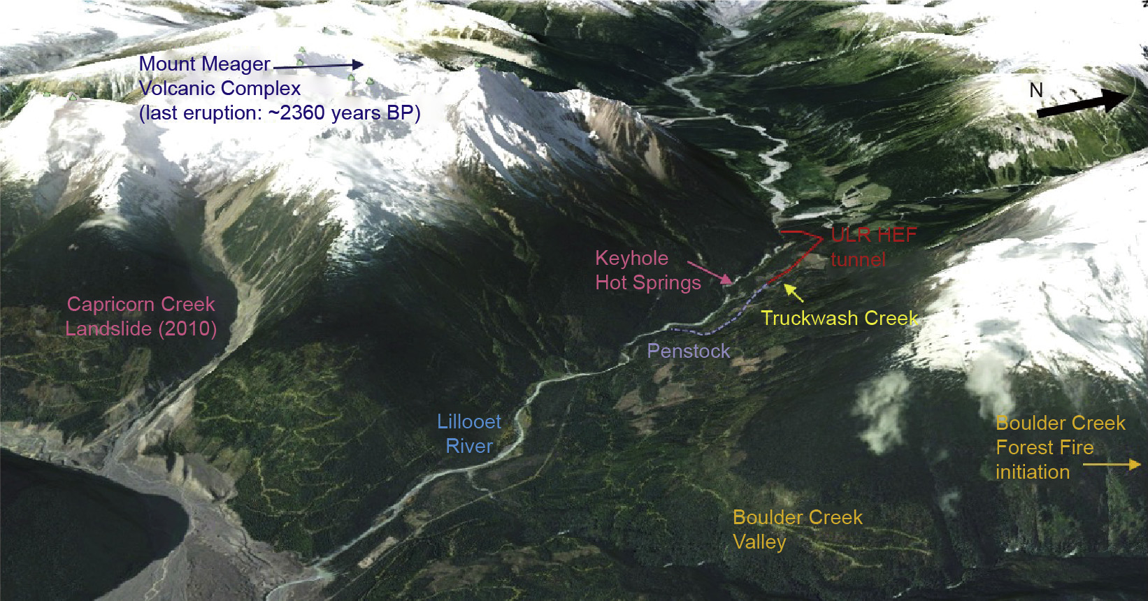
Fig. 2. Site layout within the Upper Lillooet River Valley [2].y BP: before the present.
《3.Tunneling through young volcanic deposits》
3.Tunneling through young volcanic deposits
The excavation from the upstream portal of the ULR HEF tunnel crossed through the young volcanic rocks associated with the most recent eruption of the Mount Meager Volcanic Complex, into a pumice deposit and buried soil horizon, and finally into igneous and metamorphic basement rocks. Tunneling through these deposits presented some major challenges, which are described later in this paper. The downstream heading encountered only the basement rocks, which were generally more competent and required less rock support, except at faults and shear zones. The basement rock sections of the tunnel are not described further in this paper.
《3.1.Pebble Creek Formation》
3.1.Pebble Creek Formation
The upstream end of the tunnel was excavated through parts of the Pebble Creek Formation, which comprises recent volcanic rocks and associated deposits from the ~2360 years before the present (BP) Mount Meager volcanic eruption that infilled the Upper Lillooet Valley and covered the Quaternary surficial deposits and basement rocks [3,4].
The ~2360 years BP eruption was preceded by an ejection of ash fall tephra (pumice) that left thick deposits throughout the valley, and deposited ash up to 1000 km away. The main eruption consisted of a hot block-and-ash flow with varying degrees of welding. The welded block-and-ash flow, labeled as a welded breccia, was the majority of the rock excavated in the upstream portion of the tunnel (CH 0+065 to CH 0+470). Between this fresh volcanic rock and the basement rock is an unconformity comprised of Quaternary soils and unconsolidated volcanic deposits. The unconformity was tunneled through between CH 0+466 and CH 0+478, and is referred to as "transition zone” soils in this paper, shown schematically in Fig. 3.
《Fig. 3》
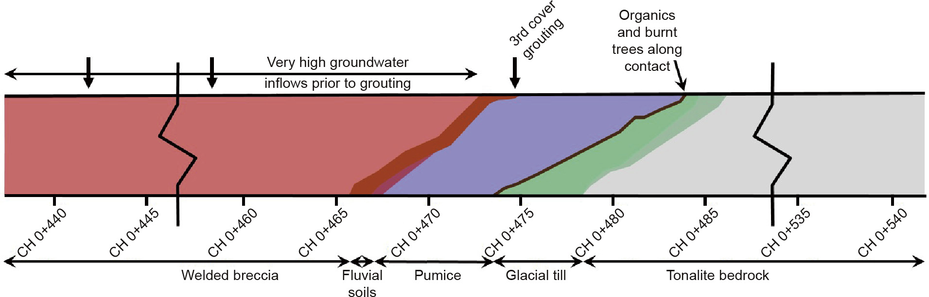
Fig. 3. Schematic tunnel profile through the transition zone soils, showing the deposits encountered along the tunnel excavation.
The deposits mined through from the upstream portal are described below from youngest to oldest [2]:
• The welded breccia is typically gravelto cobble-sized, subrounded to angular blocks of porphyritic dacite lava, in a finegrained welded ash matrix. The deposit is variably welded, and is typically massive with little jointing. Columnar jointing was observed in some more strongly welded sections—typically in the middle to lower sections of the deposit. In some locations, the boundary between flows, or pulses in a flow, could be identified. Below the welded breccia, a thin layer (< 1 m thick) of non-welded breccia was observed. The welded breccia was mapped in the tunnel from the upstream portal at CH 0+065 to CH 0+470.
• A thin layer (< 0.5 m thick) that was interpreted to be of fluvial origin was encountered below the welded breccia. This layer consisted of sand and gravel with some silt, with a reddish brown upper horizon underlain by coarse sand layers.
• Most of the unconsolidated deposits that were encountered comprised pumice from the ~2360 years BP eruption. The pumice observed on the surface occurs in the form of loose gravel deposits at numerous locations throughout the valley, at volumes that support pumice mining. The 5 m thick layer of pumice encountered in the tunnel was mainly gravel-sized, contained burnt trees (Fig. 4), and included a lower layer that was reddish brown and organic rich.
《Fig. 4》
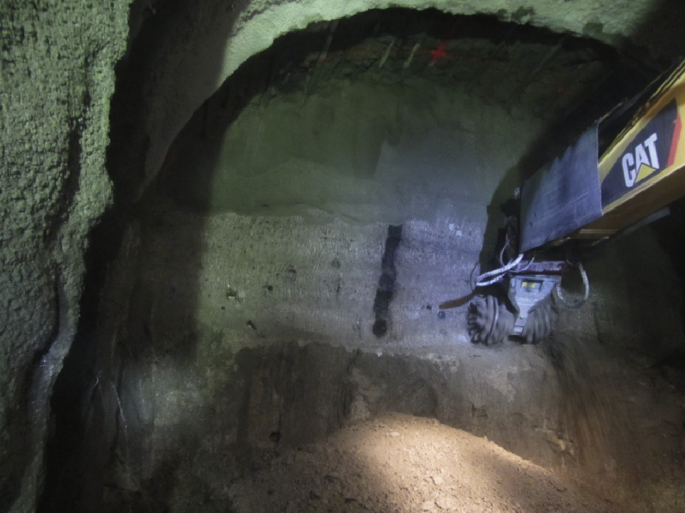
Fig. 4. Grouted pumice deposit containing a burnt tree.
• A layer that was interpreted to be the forest floor along the val-ley side prior to the ~2360 years BP eruption was observed below the pumice. The layer was of variable thickness, from 10 mm to 0.5 m thick, and was made up of pine needles, sticks, roots, and fallen trees. Carbon dating of a wood sample from this layer provided an age of 2445 14C years BP (±68 years).
• The lowermost layer encountered in the unconformity was gla cial till. The approximately 3 m thick deposit is dark brown, dense to very dense, and composed of silty sand with some cobbles,boulders, and clay. The cobbles and boulders are sub-rounded and of varying lithology (granitoid and metavolcanic).
Tonalite bedrock, which makes up the majority of the downstream tunnel excavation, was encountered below the till. Fig. 5 shows a mixed face with the majority of the layers observed during the excavation of the transition zone soils.
《Fig. 5》
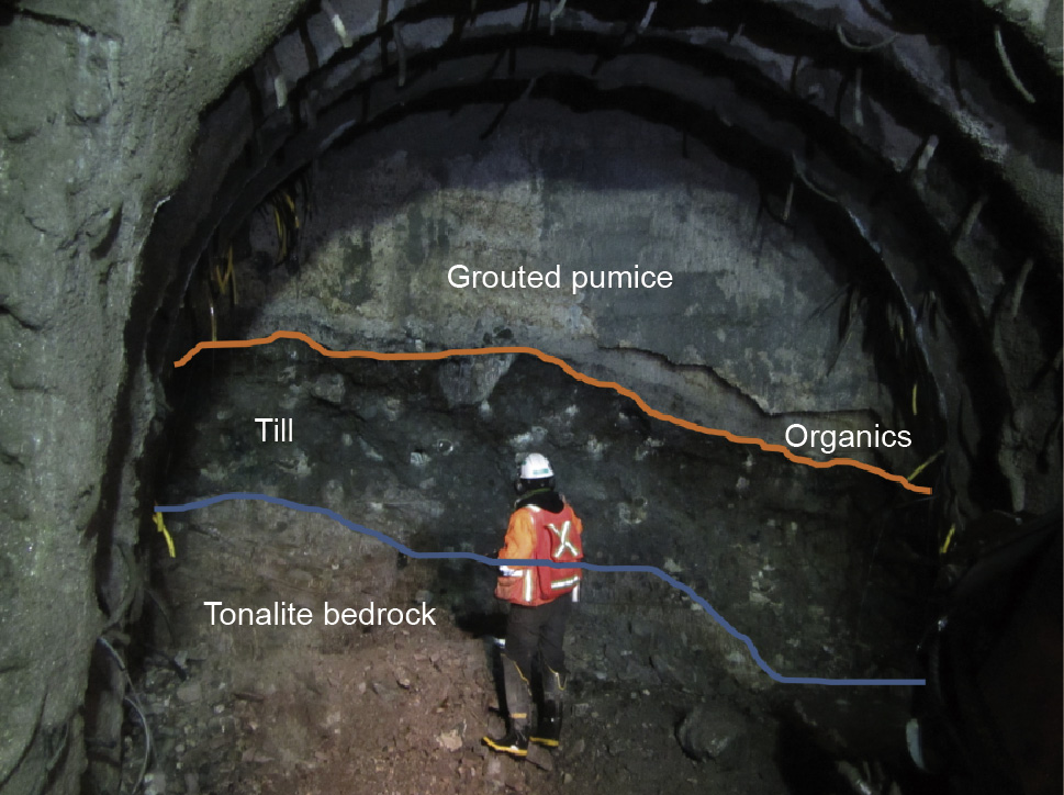
Fig. 5. Mixed face excavation with grouted pumice, organics, and till overlying tonalite bedrock.
《3.2.Tunnel inflows》
3.2.Tunnel inflows
During the initial design for the project, the rate of tunnel inflows was anticipated to be very low. However, once excavation through the welded breccia began, it became evident that the actual inflows would far exceed what was expected. Water was observed flowing at pressure through discontinuities in the volcanic rock, and appeared to be directly connected to the ULR, which was located only about 50 m away. Inflows over the first 400 m of tunnel were estimated to range between approximately 7000 L·min-1 and 8000 L·min-1. Construction water management became very complex and challenging, working adjacent to a river with significant space constraints. An extensive water treatment facility was developed, which incorporated five settling ponds, the use of flocculent, and the use of carbon dioxide (CO2) to manage pH when completing concreting works, in order to ensure the water discharge was in compliance with all federal and provincial environmental regulations. Fig. 6 shows an aerial view of the settling ponds and water treatment at the upstream portal.
《Fig. 6》
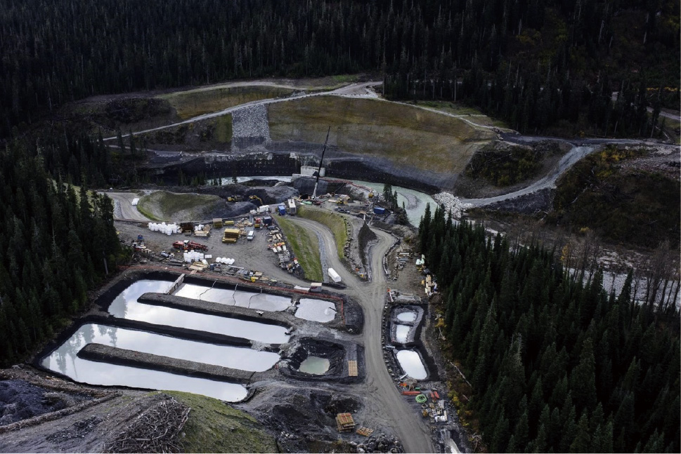
Fig. 6. ULR and construction water management facility at the upstream portal.
While some water inflows were expected within the transition zone sediments, the rates encountered in the welded breccia alone far exceeded expectations. It was anticipated that if similar inflow rates existed within the unconsolidated deposits, it would be extremely difficult, if not impossible, to excavate and support the tunnel safely. Consequently, a cover and consolidation grouting program was initiated prior to excavation through the transition zone.
《3.3.Cover and consolidation grouting》
3.3.Cover and consolidation grouting
Cover grouting was initiated from the welded breccia approximately 25 m before encountering the unconsolidated deposits, in an attempt to reduce inflows into the tunnel heading. The cover grouting was designed to "cover” the perimeter of the tunnel to a depth that would not be penetrated by the designed support (2.4 m long rock bolts). As the grouting had not been initiated when larger-than-expected inflows were first encountered, it was understood that the overall volume of water flowing into the tunnel would likely not decrease, as any water redirected away from the excavation, ahead of the face, could simply flow around and reenter the tunnel from previously excavated (but un-grouted) areas.
Thereafter, in order to strengthen the loose, unconsolidated deposits, and particularly the gravelly pumice deposit, consolidation grouting was carried out. The program was laid out such that the grout holes were up to 45 m long and there was greater than 20 m of overlap between nested rings of outwardly radiating, equally spaced grout holes (Fig. 7) [5]. Based on measured inflows and the results of water take (i.e., Lugeon) tests carried out prior to injection, the apparent viscosity of the grout mix injected was increased (i.e., thickened) and each stage was grouted to refusal, at the specified injection pressure and at a low to very low rate of injection. In this manner, adequate ground improvement to allow for stable mining conditions was achieved. The grouting program is discussed in detail in Ref. [5].
《Fig. 7》
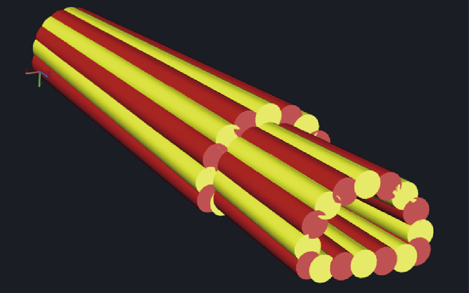
Fig. 7. Schematic of grouting program hole layouts illustrating overlapping grout covers [5].
《3.4.Tunneling and ground support》
3.4.Tunneling and ground support
Tunnel excavation was typically carried out by drilling-and-blasting methods through the welded breccia and bedrock of the ULR HEF tunnel. Excavation rounds were up to 6 m long; rock support in the welded breccia was typically 2.4 m long, 2 m spaced pattern rock bolts with welded wire, or chain-link mesh. Additional support in the form of spot-positioned rock bolts and/or shotcrete was placed where necessary.
When the excavation reached the transition zone, the blast pattern was redesigned; short blast rounds were completed for the upper portion of the face, which still consisted of high-strength welded breccia, while roadheader and hammer excavation were used for the lower portion of the face, which exposed grouted transition zone sediments.
Within 7 m of first encountering the transition zone sediments, the welded breccia had risen above the crown of the tunnel, and the tunnel face was fully composed of grouted pumice. Excavation by roadheader proceeded well through the grouted pumice and underlying organics and till layers. After a further 5 m of excavation, within a full face of transition zone sediments, the tonalite bedrock was encountered rising up from the invert. Within 11 m of mixed soil and rock conditions, the tunnel was back to a full face of solid basement rock, and was excavated by short blast rounds (Fig. 3).
Through the transition zone, umbrella support was installed. The umbrella support consisted of 0.3 m to 0.5 m spaced 12 m long canopy tubes, typically installed at an angle of 8°, with 4 m of overlap between tube sets. The canopy tubes were installed from invert to invert from the beginning of the sediments, with the number installed decreasing as the tonalite bedrock was encountered rising up from the invert. The umbrella support was combined with lattice girders and shotcrete to support the excavation. Face support was not required during excavation, as a stable face was maintained due to the consolidation grouting that had been completed earlier.
Installation of the umbrella support through the crown of the tunnel (10 o’clock position to 2 o’clock position), and lattice girders and shotcrete continued for 40 m past the start of full face rock excavation in the tonalite, due to very low rock cover over the tunnel. Although there was over 200 m of ground cover, probe drilling indicated less than 6 m of rock cover. After a full tunnel diameter (6 m) of rock cover was achieved, normal ground support with rock bolts and shotcrete was continued.
To protect against invert erosion and prevent undermining of the footings of the lattice girders, a concrete invert slab was required through the transition zone sediments. This invert slab was continued through the entire 2500 m length of the tunnel in order to prevent erosion of other weak zones that had been encountered, as well as provide ease of access for future tunnel inspections.
During construction, it was observed that some zones of the welded breccia that were more poorly welded than others were experiencing degradation over time—that is, the surfaces of the walls and crown of the tunnel, which were solid rock immediately after excavation, had broken down to the point where loose sand could be scraped off the surface. Laboratory testing including slake tests, modified slake tests, ethylene glycol testing, and X-ray diffraction (XRD) mineral identification provided no indication that there could be potential degradation issues with the rock. However, thin sections did identify varying degrees of welding between samples that showed degradation and those that did not. To prevent further degradation of the tunnel walls and possible erosion during tunnel operation, the more poorly welded breccia was identified, mapped, and marked along the tunnel crown and walls, and those areas were covered with a final lining that consisted of 100 mm of shotcrete with welded wire mesh to improve shotcrete adherence to the rock.
《4.General project challenges》
4.General project challenges
In addition to the geological challenges that were encountered during tunneling, numerous other challenges were faced by the ULHP due to working in remote British Columbia.
《4.1.Landslide risk》
4.1.Landslide risk
The Mount Meager Volcanic Complex, which is located directly across the valley from the upstream portal and tunnel intake structures, has been labeled the most landslide-prone mountain in Canada [6]. Studies predating the ULHP indicated that there was a risk of landslide occurrence, both volcanic [7] and non-volcanic [6], from the mountain that could directly impact the ULR, and have impacts reaching far downstream.
The Province of British Columbia had previously commissioned the development of a landslide management plan in 1999 to reduce the risk to the public from landslides originating from the Mount Meager Volcanic Complex. This plan included operational shutdown procedures for the Meager Valley to prevent access to the area in the event of specific climatic factors that could increase the potential for a landslide to occur, including rainfall and temperature thresholds that could lead to excessive snowmelt, and therefore runoff on the mountain.
In August of 2010, an operational shutdown was implemented when temperature thresholds were reached (greater than 25 °C for 6 consecutive days), and the Meager Valley was closed to public access. On 6 August 2010, a landslide originated from the Capricorn Creek Drainage (a main valley off the south side of the Mount Meager Volcanic Complex), which entered Meager Creek and then the ULR. The landslide narrowly missed campers in the provincial campground located in the Upper Lillooet Valley, just north of the confluence with Meager Creek. This campsite was permanently closed after the 2010 landslide. The Capricorn Creek Landslide, as the event was subsequently named, was determined to be the second-largest documented landslide in Canadian history [8].
Numerous studies have documented additional potential instability from the Mount Meager Volcanic Complex. The Capricorn Creek Landslide entered Meager Creek, and then the ULR, approximately 3 km south of the project; thus, it would not have directly impacted the project or its infrastructure (Fig. 2). Of particular interest for the ULHP was the eastern flank of the mountain and the risk from the Job Creek Drainage, which is located just upstream of the ULHP intake.
In order to mitigate the risk during construction, a similar landslide management plan was developed with Low, High, and Extreme Risks management outlined. This management plan included access restrictions for areas of the project that were dependent on rainfall or temperature thresholds. If temperatures were higher than an average of 25 °C for more than 4 consecutive days, or if more than 50 mm of rain was received, the High Risk category was enacted; this involved log in/log out procedures throughout most of the site and daytime travel only, as well as the complete closure of the upstream portal and intake work areas. The Extreme Risk threshold was exceeded as soon as temperatures reached 35 °C, or more than 70 mm of rain was received in 24 h.Under the Extreme Risk threshold, the entire ULHP site was effectively shut down and the FSR gates were locked to prevent any public access.
Throughout the project, the temperature threshold resulted in 20 days of lost production in 2015, and 31 lost days in 2016. The rainfall threshold was reached three times, with 6 days of lost production in 2015, and two times in 2016, with 4 days lost.
《4.2.Climatic challenges》
4.2.Climatic challenges
4.2.1.Summer construction
One of the hazards of working in remote forested locations is forest fires. The forests of British Columbia are prone to both natural and human-caused fires in the summer months. In order to work in forested locations when there is a high fire risk, precautions must be undertaken by contractors, including having firefighting equipment readily available throughout the site. However, even with precautions in place, the risk still exists. In the summer of 2014, almost 360000 ha (1 ha = 104 m2) of land burned in British Columbia, the third-highest loss to fire in the history of the province. The 2015 fire season was above average as well, resulting in additional personnel being brought in from around the world to help. One of the largest fires in the province in 2015 was the Boulder Creek Forest Fire; this was started by a lightning strike near the top of the Boulder Creek Drainage (Fig. 2), which proceeded to burn over 6700 ha of land [9].
The Boulder Creek Forest Fire started on 30 June 2015, approximately 5 km up the Boulder Creek Valley from the project site (Fig. 2). The fire remained relatively small for almost a week, and then moved down the valley toward the project. On 4 July 2015, the fire had crested the ridge into the Upper Lillooet Valley, and the project site was evacuated (Fig. 8). The project site remained under mandatory evacuation for almost 2 months. However, even with the large amounts of forest that were burned throughout the project area, only relatively minor physical project losses were experienced; the main damage was to the recently completed transmission line, and there was significant impact on the overall project schedule.
《Fig. 8》

Fig. 8. Boulder Creek Forest Fire as it entered the Upper Lillooet Valley above the project site on 4 July 2015, the day of evacuation.
Shortly after the forest fire evacuation was lifted, large amounts of rainfall occurred, which resulted in significant flooding of the ULR and debris flows from tributaries. The access FSR was damaged in numerous places; access to the site was cut off for 2 days,requiring site work to be shut down due to lack of emergency access.
4.2.2.Winter construction
Winter work was not originally planned for; however, due to the number of days that were lost during the summer work periods because of landslide risk shutdowns, the Boulder Creek Forest Fire, flooding and debris flows, and poorer rock quality than originally anticipated, construction proceeded through the winters of 2015–2016 and 2016–2017 in order to reduce the overall project schedule impact. The winter of 2015–2016 was relatively warm, with above-average precipitation; portions of the project site received varying accumulations of snow and experienced high avalanche danger. The forestry road required constant plowing and maintenance to maintain safe site access (Fig. 9). Numerous notable avalanche chutes intersected the FSR throughout the site, requiring continuous avalanche monitoring and control throughout the winter months by trained avalanche professionals. Many work hours, often on a daily basis, were impacted due to avalanche control and cleanup.
《Fig. 9》
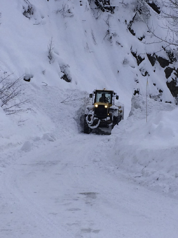
Fig. 9. Clearing of deep snow from the FSR.
《4.3. Environmental challenges: Wildlife》
4.3. Environmental challenges: Wildlife
The ULHP is adjacent to the Upper Lillooet Provincial Park and shares the "park-like” setting and many of the natural characteristics of a park. A large number of species live in the area, some of which are protected; this situation required the implementation of mitigation strategies to reduce the project impact on protected species. Significant environmental studies were conducted prior to construction during the environmental assessment process in order to determine the species present, overall impact, and species requiring management and mitigation during construction. Notable species that required attention were grizzly bears, wolverines, coastal tailed frogs and, in particular, mountain goats. Mitigations included travel-restricted times during migratory timeframes, no construction activities during migratory and denning periods, monitoring of the noise level, and visual surveillance. Some of these restrictions were amended and additional mitigations were introduced after the wildfire, in order to allow continued access during the winter months, when constriction had not originally been anticipated.
Mitigations for the mountain goats remained one of the more challenging conditions of the project. The mountain goats live on the lower valley steep cliffs throughout the winter months, and migrate up the mountainsides for the summer months, with one of their main migration corridors being at the ownstream portal of the tunnel at Truckwash Creek, at 44.7 km of the FSR. The location of the migration corridor adjacent to the downstream portal of the tunnel and access road to the intake resulted in strict work restrictions. Visual and auditory berms were constructed around the downstream portal of the tunnel, and all construction work had to shut down completely for 2 weeks both in spring and in fall during the migration timeframes, which were based on set snow thresholds. In addition, daily shutdowns for the months of November and May were implemented, at 2 h before and 1 h after sunrise, and 1 h before and 2 h after sunset. During these restricted times, no travel was allowed on the FSR and no work was allowed at the downstream portal in order to allow undisturbed travel for the mountain goats through the corridor. Construction was also required to stop if mountain goats were visually spotted within the corridor. During the migration months, work days at the downstream portal were reduced from the normal 10 h to as little as 5 h for a shift. Throughout the winter months, the mountain goats were observed by human monitors on a daily basis to ensure that their normal activities were not being disturbed by any construction activity (Fig. 10). Throughout the goat monitoring, it was observed that the project had minimal impact on the mountain goats, and they did not generally appear to be disturbed by construction noises or activities.
《Fig. 10》

Fig. 10. Goat monitoring. Top left: valley sides above Keyhole Falls—the winter active range of the mountain goats; right: goat monitor watching mountain goats; bottom left: mountain goat above Keyhole Falls.
《5.Conclusion》
5.Conclusion
The construction of the ULHP faced many unique challenges that were overcome to deliver the 106.7 MW clean energy project. The 2500 m long tunnel was constructed in part through the most recent volcanic deposit in the Province of British Columbia, including a zone of unconsolidated soils. An originally unplanned grouting program was designed and implemented to manage unexpected water inflows and consolidate largely unknown materials, which differed greatly from the deposits that were encountered during various project investigations. Faced with challenging geology and some of the strictest environmental requirements encountered by a run-of-river project in the Province of British Columbia, the owner, engineer, and contractor worked as a team to come up with solutions and manage the challenges. The project was delivered relatively close to the original timeline, even after substantial shutdowns occurred due to unforeseen force majeure and challenging tunneling conditions.
《Acknowledgements》
Acknowledgements
The authors would like to thank Renaud de Batz and Oliver Robson of Innergex Renewable Energy Inc. for their permission to publish this paper, and acknowledge the hard work and efforts of the full time on-site team—Brittany Linnett, Chase Reid, and Ryan Preston of Golder Associates Ltd.; the grouting team—Grant Bonin, Bill Lillico, Rob Chu, Jeremy Hoy, and James Smith; and Danny Dugas, David Gagnon, and Joé Duval Bourgault of EBC Inc. Their dedication and professionalism for the duration of the project contributed to a safe and successful excavation through very challenging conditions.
《Compliance with ethics guidelines》
Compliance with ethics guidelines
Nichole Boultbee, Oliver Robson, Serge Moalli, and Rich Humphries declare that they have no conflict of interest or financial conflicts to disclose.


 京公网安备 11010502051620号


