

《1. Introduction》
1. Introduction
During urbanization, a significant proportion of the world’s urban rivers have been channelized [1]. This situation is not confined to a particular geographic region, but rather is a global situation [2]. River channelization can effectively increase the ability of rivers to convey flows, which is helpful for flood control [3]. However, it also reduces the flow retention time, leading to water shortages in these rivers at certain times [4]. The water shortage problem is exacerbated by other factors, such as the everincreasing water demands by humans and the low retention of rainwater that results from transforming a natural basin landscape into an impermeable surface [5]. Water shortages have led to obvious environmental degradation in channelized rivers [6]. Sustaining environmental flows (e-flows) has become a basic tenet of river environment protection and water resources management [7], but must also be extended to channelized rivers.
Many researchers have studied e-flows in channelized urban rivers, leading to the development of many e-flow assessment methods. The water requirements for habitat provision, pollutant dilution, and recreation (i.e., scenery) are commonly considered in assessments of urban river e-flows [8]. Many methods have been developed to estimate the e-flow requirements for habitat provision. These methods can be classified into four general categories: hydrological, hydraulic rating, habitat simulation, and holistic [9]. To determine the pollutant dilution requirements, mass-balance equations have been used to determine the water volume required to dilute pollutants to meet specified standards [10,11]. To meet recreation requirements, hydraulic methods have been adopted [12].
After the e-flows were assessed, many researchers further studied how to satisfy the e-flows. This work has focused on the use of different water resources, such as storm water, reclaimed water from wastewater treatment plants, and freshwater from reservoirs, to satisfy e-flows in economically sound and highly reliable ways [13,14].
Despite the innovative and valuable research on e-flows, e-flow shortages remain common [15,16]. It is therefore necessary to explore the possible reasons for the problem. The most commonly proposed explanations are intense competition among water users, incomplete implementation of the designed e-flow supply plan, and variable and limited water resources. In addition, we hypothesized that inappropriate design of the physical structures in channelized rivers would be an important reason. This is because the eflow assessment results and supply scheme are closely related to the physical condition of the channelized rivers [17,18]. There is an obvious chain of influence in e-flow management: The river’s physical condition directly influences the water velocity and depth in the river channel [19]. Both factors are closely related to the eflow’s functions in habitat provision, pollution dilution, and recreation, and consequently influence the e-flow assessment results [12]. These results further influence the choice of water resources for e-flow supply and the supply route, which further influence the financial input required for water transfer and the water resource allocation among the different users in a region [20–23]. For channelized urban rivers, the channels are artificial. If the physical condition of the channels is not properly designed, the e-flow requirement may increase and the pressures on the e-flow supply and allocation among water users will also increase, leading to great difficulty in following the e-flow supply plan and, often, failure of the e-flow supply scheme.
In channelized urban rivers, small overflow-type dams (i.e., weirs) are constructed to reduce flows and store water. Many types of weirs, such as concrete weirs and rubber dams, have been used in rivers. In the present study, we will only consider concrete weirs, which are widely used due to their low complexity: The weir size cannot change after construction [24]. Weir height is an important design parameter for weirs and for river channel designs that incorporate weirs [25]. In the traditional weir heightdetermination framework, flood control and water retention are the two major concerns [26,27]. In that context, e-flows are implicitly considered based on the assumption that higher weirs store more water in the river and can therefore better provide the required e-flows. For urban rivers in cities with a high population density in their basins, flood control is the most important concern. Accordingly, the designed flood level (e.g., for floods with a 20-year return interval) is set as the inflow, and the maximum weir height required under this defined level of flood risk is set as the weir height [26,27]. This weir height is the maximum allowed height in the river, and offers the largest water storage capacity.
However, although this highest weir can potentially store the largest amount of water, it does not adequately account for the real available inflows that will be used for e-flow supply, and the future e-flow provision effect will be poor if the most frequent inflows are insufficient to allow water to rise high enough to flow over the weirs. Algal blooms are a serious environmental problem in urban rivers [28], especially for channelized rivers whose pollutant degradation ability is limited. For algal blooms to develop, the flow velocity must be low [29]. With increasing weir height, the flow area of the channel’s cross-section will increase; consequently, the average flow velocity in the channels will decrease under a given inflow. The low flow velocity will therefore increase the possibility of algal blooms. If the weirs are too high and the real inflows for e-flow provision are limited, the river may only flow intermittently, with the flow velocity decreasing to zero at times. The risk of algal blooms then becomes high, especially when there is continuous pollutant input.
The goal of the present study was to refine the traditional weir height determination framework, which only explicitly accounts for flood control and water retention requirements, to explicitly account for the need to ensure adequate e-flows, thereby reducing the risk of problems such as algal blooms. As a case study, we chose Shiwuli River in Hefei, China, a typical channelized urban river. In the following sections, we propose the new method for weir height determination, describe the study site, and explore the influence of the required e-flow supply on the designed weir height.
《2. Method development》
2. Method development
Fig. 1 compares the steps in the traditional weir height determination framework [26,27] with the steps in the proposed new framework. In the old framework, the weir height is determined based only on the flood control and water retention requirements. The weir height determined by the traditional framework is used in the new framework as the upper threshold for weir height. Because the traditional weir height determination framework is a familiar basic method in hydraulic project design, we will briefly give the key equations in Section 2.3 and will not describe it in detail here. Hydraulic design for details can be referred to textbooks (e.g., Refs. [26,27]).
《Fig. 1》
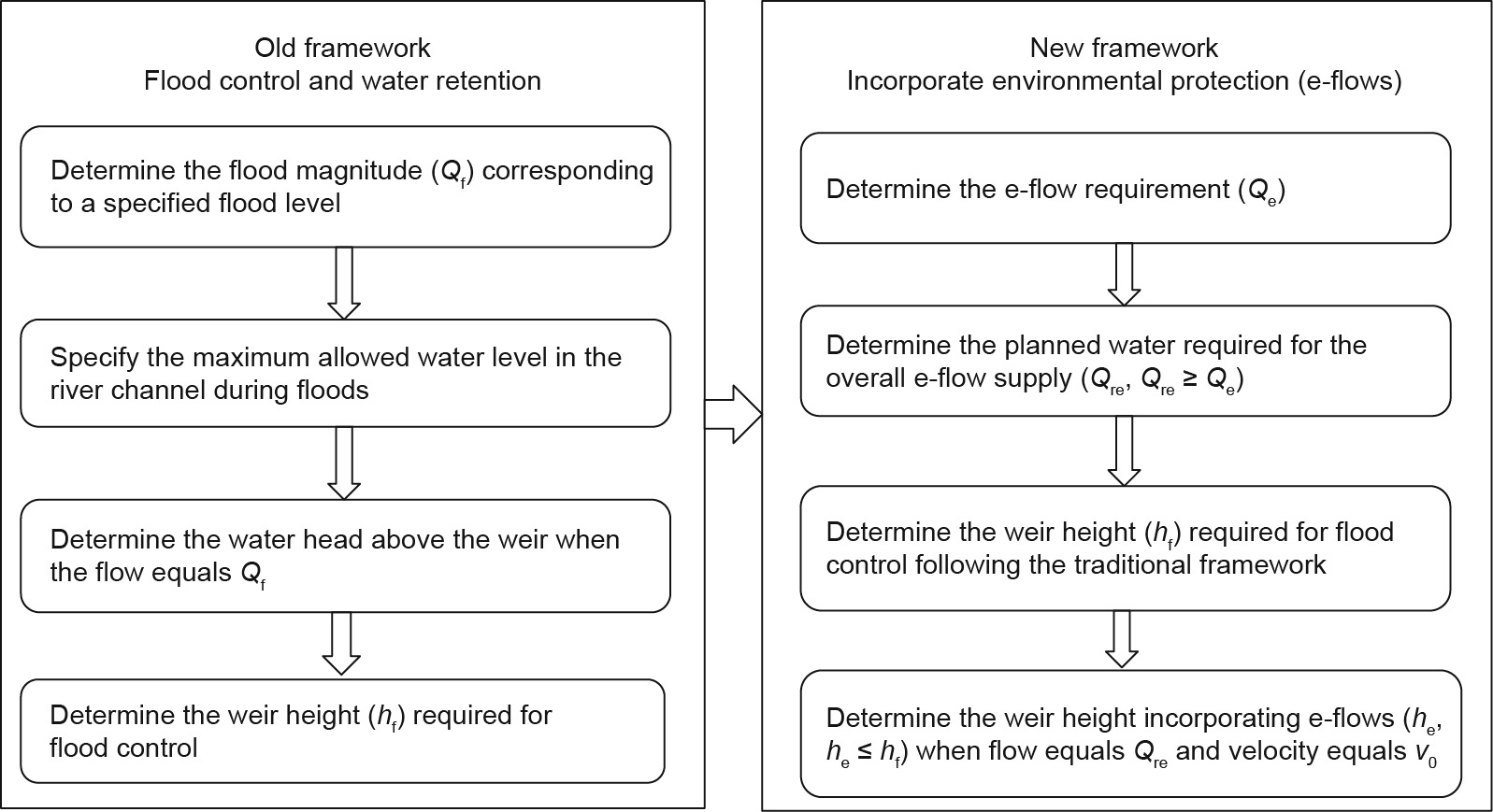
Fig. 1. Comparison of the traditional and new frameworks used for weir height determination. v0 is a specified flow velocity to reduce the possibility of algal blooms.
In the new framework, the e-flows are determined first. They are then set as the minimum flow that must be satisfied by the river channel. The real flows that will be used to determine the e-flow supply are then determined, and these should be no less than the defined minimum e-flows. These flows are then used as the inflow for the weir, and this inflow is used for the weir height determination. Due to the high risk of algal blooms in channelized urban rivers, we chose reducing the possibility of algal blooms as a major environmental objective in the new framework.
《2.1. E-flow determination》
2.1. E-flow determination
For channelized rivers, their channels have been transformed into straight, trapezoidal-profiled channels of concrete, leading to the disappearance of valuable species [30–32]. The requirements of habitat provision become not important. Thus, in the present analysis, we have only considered the e-flows required to support pollutant dilution and recreational opportunities. However, if some valuable species must be protected in the river channel, the flow requirement for habitat provision can be determined according to accepted methods (e.g., Ref. [9]).
2.1.1. E-flows for pollutant dilution
The water requirement for pollutant dilution can be determined based on a mass-balance equation [12], as follows:

where Qd is the water requirement for diluting the pollutant to the target (permitted) quality; Qp is the volume of polluted water; Cp is the concentration of the pollutant discharged into the urban river; Cmax is the specified (target) water quality; M is the pollutant reduction through degradation; and C0 is the concentration of pollutant in the water used to provide the e-flows.
2.1.2. E-flows for recreation
The river bed of a channelized river has been transformed into a steep-sided trapezoid shape, in which the water surface area usually does not increase significantly with increasing depth and does not have a breaking point in the curves that describe the relationship between water surface area and discharge. Thus, for channelized urban rivers, recreational e-flows (i.e., e-flows for river scenery) must be included in the design to ensure that the river bed is not bare, and the water depth is usually set at no less than 0.2 m [12].
In addition, in channelized urban rivers that have been divided into segments that are isolated by weirs, longitudinal connectivity of the flows is a key issue to support the recreation function as well as the transportation requirements for materials and energy. To maintain flow connectivity, the water level at the upstream cross-section of a given weir needs to be greater than the height of the weir; at lower water depths, water cannot flow over the top of the weir. In addition, the lowest water level in any river segment should be no less than 0.2 m to prevent the channel bed from becoming bare [12]. After the water level rises above the weir, any amount of continuous water input into a river segment will ensure that the water level remains above the weir height. Thus, to maintain longitudinal river connectivity, we only need to ensure that the lowest water level is greater than or equal to 0.2 m. Within a river segment, the water depth is usually lowest at the upstream end of the segment, so we defined the flow required in this river section as the required e-flow.
Manning’s equation is one of the most commonly used equations in determining open-channel flows. This empirical equation applies to uniform flow in open channels and is a function of the channel velocity, flow cross-sectional area, and channel slope [33]. It is used to determine the required flow to ensure that the lowest water level remains equal to or greater than the specified value (i.e., 0.2 m in the present study).

where Qr is the water requirement for recreation; n is Manning’s roughness coefficient; A is the area of water in a channel crosssection; R is the hydraulic radius; S is the channel slope;  is the channel bottom width; h is the water depth; and m is the side slope coefficient.
2.1.3. Overall e-flows
The overall e-flow requirement, Qe, is then calculated as follows:

where Qse is the water consumption that results from seepage and evaporation, which is considered to be negligible in the following case study.
《2.2. Determination of water available for e-flow provision》
2.2. Determination of water available for e-flow provision
The e-flow determined based on the methods in Section 2.1 represents the minimum flow that should be maintained in the river. Greater flows in channelized rivers would be more beneficial for pollution dilution and recreational use, but that amount of water may not be available in practice. The actual flow supplied to a river depends on the total available water resources, the water requirements of different users, the financial allowance provided for management of the river, and other factors. The actual flows represent the balance that results from compromises among these factors. Many methods have been developed to determine the optimal flow for e-flows [34,35]. In this research, we have not advanced beyond the previous research on this subject. Instead, we have chosen to examine actual flow scenarios, and explore their influence on weir height. In addition, one urban river is usually kilometers long with several weirs along the river. The inflows to different weirs may be related or different. The available inflows for each weir should consider the cascaded effects.
《2.3. Upper thresholds of weir heights》
2.3. Upper thresholds of weir heights
The upper thresholds of weir heights are the heights following the traditional framework for flood control and water retention. The weir height is determined based on traditional weir equations, and the key equations are as follows [26,27]:
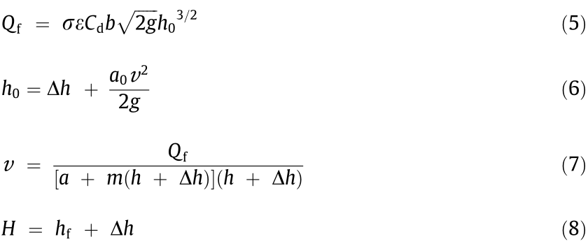
where Qf is the designed flood magnitude, which is determined by choosing a suitable flood return period and analyzing the historical flow time series; σ is the submergence coefficient; ε is the lateral contraction coefficient; Cd is the discharge coefficient for weir flow; b is the length of the weir; g is the acceleration due to gravity; h0 is the total hydraulic head at the upstream side of a weir;  is the height of the water above the crest of the weir;
  is the kinetic energy correction factor;
  is the flow velocity; m is the side slope coefficient; H is the designed water level during flooding in the river; and hf is the weir height determined according to the requirement for flood risk control.
In these equations, Qf, H, and the parameters σ, ε, Cd, b, g, ,  , and m are known or predetermined, and are used to determine the unknown weir height hf.
《2.4. Weir height incorporating e-flows》
2.4. Weir height incorporating e-flows
Because algal blooms are a serious environmental problem in urban rivers [28], we chose them as a primary problem that must be avoided by providing an appropriate level of e-flows. Previous research on algal blooms has indicated that when the flow velocity is high, algal blooms seldom occur [36–39]. Thus, the maintenance of high flow velocity should be incorporated into the weir height determination to reduce the possibility of algal blooms.
The flow velocity within each river segment (i.e., the river channel between two weirs) is not uniform. In this research we simply use the flow velocity at the upstream side of a weir to approximately represent the flow velocity within the river segment upstream of the weir. The velocity at the upstream side of a weir will be controlled to be no less than a specified flow velocity ( ) to reduce the possibility of algal blooms.
The required weir height is also determined based on the traditional weir equations, as in the determination of the upper weir height threshold. The major difference is that: In the weir height determination for reducing algal bloom possibility, the inflow is the planned flow (Qre) that is required to provide the e-flows (if the planned water for the e-flow supply varies with time, the minimum water supply is set as the inflow), and the specified flow velocity (i.e., ) is known, whereas in the determination of the upper weir height threshold (hf), the inflow is the peak flood and the maximum water level is known. To satisfy the flood control requirement, the required weir height (he) should be no greater than hf.
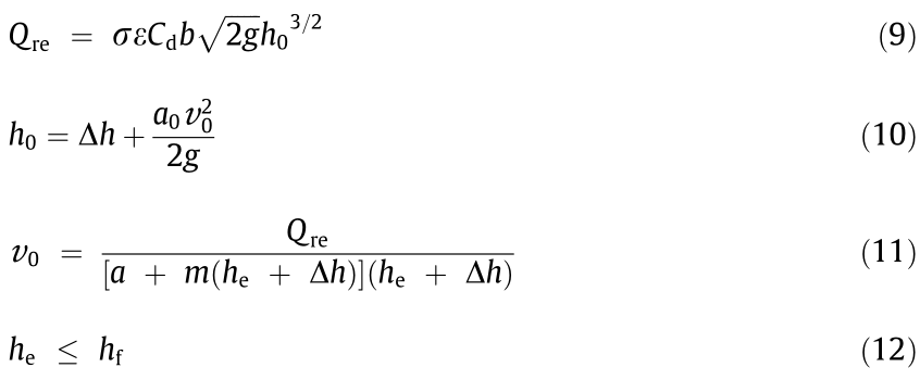
where Qre is the planned flow for e-flow provision and he is the weir height determined by accounting for e-flows.
In these equations, Qre, , hf, and the parameters σ, ε, Cd, b, g, , , and m are known or predetermined, and are used to determine the unknown weir height he.
《3. Case study》
3. Case study
The Shiwuli River is located in upstream of Chaohu Lake, which is the second largest inland lake in China, and runs through the urban region of Hefei City (unlike Western cities, Chinese cities usually include both a built-up area and a rural area within their administrative boundaries). The river is 22.64 km long and its basin covers 111.25 km2 . To enhance the river’s flood transfer ability, it has been channelized into a typical trapezoidal cross-section with concrete walls. Eight weirs have been constructed in the river to store water and provide e-flows. The weir heights of W1, W2, W3, W4, W5, W6, W7, and W8 (determined based on the traditional weir height determination framework) are 3.0, 2.8, 1.5, 2.6, 1.7, 0.7, 1.8, and 1.7 m, respectively, which were determined based on the traditional weir height determination framework.
As a result of limited water input due to excessive withdrawals in upstream regions, the flows in the river are intermittent. To restore the river’s landscape and create a recreation site for citizens, the government plans to improve water quality and secure e-flows in the river. The treated water from the Shiwuli Wastewater Treatment Plant (Shiwuli Plant; with a treatment capacity of 2.5 × 10⁵ t·d-1 , equivalent to 2.89 m3 ·s-1 ) and the Hudaying Wastewater Treatment Plant (Hudaying Plant; with a treatment capacity of 1.0 × 10⁵ t·d-1 , equivalent to 1.16 m3 ·s-1 ) will be used to meet the e-flow requirements. The collected rainwater and water from Swan Lake will not serve as regular water sources. All industrial and domestic wastewater discharged into the river is expected to be treated by the two plants to achieve quality Level IV (Level IV is better than Level V; Level V is the allowed water quality for river scenery in China) in the released water according to the Chinese surface water standard [40]. In addition, to control non-point-source pollution caused by rain, many stormwater retention tanks will be constructed so that captured water can be treated to quality Level IV before being released into the river. Planners believe that the wastewater control and treatment projects will control pollution releases into the river and produce better river water quality than the allowed water release standard of V. Thus, the e-flows for pollutant dilution are negligible in this case.
The planned quality of water released from the two plants will meet the standard for Level IV, which is better than the allowed water quality (Level V) for the river. Part of the effluent (1.16 m3 ·s-1 ) from the Shiwuli Plant will first be transferred to the planned Huizhou Dadao Wetland, located upstream of the Shiwuli Plant for further treatment, and then be transferred immediately into the river downstream of Swan Lake (Point A), above the eight weirs. The effluent (1.16 m3 ·s-1 ) from the Hudaying Plant will be released directly into the river channel to supply the e-flows (Fig. 2(a)).
《Fig. 2》
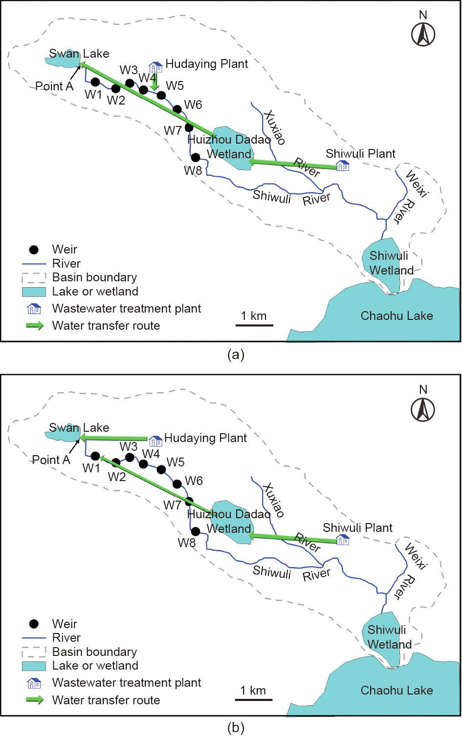
Fig. 2. Water transfer routes for the e-flow supply [41]. (a) Old route; (b) new route proposed in this research.
《4. Results》
4. Results
In this research, we did not change the number and locations of the weirs, but have instead recalculated the target weir heights to demonstrate the use of the proposed framework. In future research, it will be useful to expand the new framework to include such factors as weir location and type. The weir shape influences the submergence coefficient σ, the lateral contraction coefficient ε, and the discharge coefficient for the weir flow Cd. After the shapes are chosen, these parameters can be determined by consulting a standard hydraulic design textbook. In this research, to reduce the complexity of the computation and focus on the determination of weir height, we simply set σ, ε, and Cd to values of 1 (means no submergence), 1 (means no lateral contraction), and 0.502 (commonly used for weir), respectively [27]. If these parameters are set at other values, it is still easy to determine the weir height following the framework proposed in this research. In addition, previous research on algal blooms has indicated that when the flow velocity is greater than 0.1 to 0.2 m·s-1 , algal blooms seldom occur [36–39]. We therefore considered the maintenance of two flow velocities ( = 0.1 and 0.2 m·s-1 ) in our case study.
Table 1 summarizes the required weir height under a flow velocity of 0.2 and 0.1 m·s-1 . The weir heights determined according to the new framework are lower than the present weir heights. This change is because the old weir height is determined according to the peak flow in the river, without considering the flow velocity or e-flow requirements, whereas the weir height calculated under the new framework accounts for the actual flows required for the e-flow supply and the flow velocity maintenance requirement. The required weir height also differs among the river segments, with segment S1 between Swan Lake and the most upstream weir (weir W1) and segment S8 farthest downstream (between weirs W7 and W8). We will not consider the river segment downstream of weir W8 in this research. At both values, the highest weir was W5, with heights of 0.77 and 1.73 m at velocities of 0.2 and 0.1 m·s-1 , respectively. The lowest weir was W4, with heights of 0.44 and 1.02 m at velocities of 0.2 and 0.1 m·s-1 , respectively.
《Table 1》
Table 1 The weir heights required under the present e-flow supply.

Flow velocities of segments S1, S2, S3, S4, S5, S6, S7, and S8 (Fig. 2(a)) under the present e-flow supply routes are 0.05, 0.05, 0.08, 0.04, 0.10, 0.22, 0.02, and 0.02 m·s-1 , respectively. Only the velocities at weirs W5 and W6 are greater than or equal to 0.1 m·s-1 . The flow velocities at weirs W7 and W8 are the lowest, so the risk of an algal bloom is highest within the river segments upstream of these weirs (i.e., segments S7 and S8). In addition to reducing nutrient concentrations by treating the water and managing flow velocity increases, mechanical aeration is also widely used. To reduce the possibility of an algal bloom, mechanical aerators should be installed in segments S7 and S8, which have the lowest flow velocities under the current system.
We further determined the flows required to satisfy the flow velocity criterion (Table 2). Under the present water availability (i.e., 2.32 m3 ·s-1 from the two plants), segments S3, S5, and S6 can satisfy their flow velocity requirements at a flow velocity of 0.1 m·s-1 ; in contrast, when the flow velocity is set at 0.2 m·s-1 , only the flows for segment S6 can be satisfied. Thus, the present weir height is too high for the e-flow provision required to reduce the risk of an algal bloom.
《Table 2》
Table 2 Required flows to satisfy the flow velocity requirement that will avoid an algal bloom.

《5. Discussion》
5. Discussion
《5.1. Other possible weir heights》
5.1. Other possible weir heights
The weir heights described in the previous section correspond to the present e-flow supply plan. In real-world e-flow management, the weir height is commonly determined before the e-flow supply plan is developed. However, because of the importance of e-flows, these flows can be defined first, and then weir designers can define an acceptable range of heights and suggest a preferred weir height based on our new framework.
The lowest possible weir heights correspond to the condition in which only the river’s minimum e-flows are satisfied, whereas the highest possible weir heights correspond to the condition in which all possible available water is discharged into the river at the site farthest upstream in the river’s channel (Point A in Fig. 2(a)). The minimum e-flows for river segments S1, S2, S3, S4, S5, S6, S7, and S8 are 0.56, 1.33, 1.00, 1.33, 1.10, 0.50, 1.04, 0.90 m3 ·s-1 , respectively. The water supply for e-flow requirements in an upstream river segment can serve as the e-flow supply for its downstream segments. The e-flow requirement for segment S2 is 1.33 m3 ·s-1 . Thus, the actual flow for the river segments below segment S2 will be no less than 1.33 m3 ·s-1 . The weir heights of W1, W2, W3, W4, W5, W6, W7, and W8 under the minimum e-flows are 0.27, 0.66, 0.58, 0.51, 0.42, 0.42, 0.35, and 0.35 m, respectively. These weir heights are the lowest values for the river. For weir design, the weir height should always be at least these values, no matter what e-flow supply routes are adopted for management of the water resources. For the Shiwuli River, the stable water resources for e-flow supply are the effluents from the Shiwuli and Hudaying Plants. The maximum regular stable water supply for each river segment is equal to 2.32 m3 ·s-1 (2.0 × 10⁵ t·d-1 ) when all the effluent from the Hudaying Plant (1.0 × 10⁵ t·d-1 ) and part of the effluent from the Shiwuli Plant (1.0 × 10⁵ t·d-1 ) are available; the remainder of the effluent from the Shiwuli Plant will be transferred to other regions. The rainwater and water from Swan Lake are not stable, and are not taken into account in our analysis. Table 3 summarizes the corresponding weir heights. These values are the highest weir heights and should not be exceeded, especially for the values corresponding to a velocity of 0.1 m·s-1 .
《Table 3》
Table 3 Weir heights under the condition in which all the effluent from the Hudaying Plant and part of the effluent from the Shiwuli Plant are transferred to upstream river segments.

After determining the acceptable range of weir heights, we further determined the preferred weir height by designing the preferred e-flow supply route and scheme and setting the flow velocity threshold to 0.2 m·s-1 . The previous water supply route (Fig. 2(a)) transfers the effluent from the Shiwuli Plant into the river immediately downstream of Swan Lake. The required pipeline will be longer than 21 km, and will transfer 1.16 m3 ·s-1 of water (1.0 × 10⁵ t·d-1 ) upstream every day. The daily energy cost of this transfer (i.e., pumping costs) will be significant. To reduce this cost, we recommend a modified water supply route (Fig. 2(b)). The e-flow requirements in segments S2 and S4 are both 1.33 m3 ·s-1 , which amounts to 1.15 × 10⁵ t·d-1 , and this cannot be satisfied by the effluent from the Hudaying Plant (1.16 m3 ·s-1 , 1.0 × 10⁵ t·d-1 ). The e-flows must therefore be met by using the combined effluents from the Hudaying and Shiwuli Plants. We propose to reduce the large, long-distance water transfer from the Shiwuli Plant. In this new approach, effluent from the Shiwuli Plant is transferred to segment S2 with a flow rate of 0.23 m3 ·s-1 (1.99 × 10⁴ t·d-1 ), and all the effluent from the Hudaying Plant would be transferred to Point A. The preferred weir heights of W1, W2, W3, W4, W5, W6, W7, and W8 under the proposed new e-flow supply route (Fig. 2(b)) are 0.74, 0.69, 0.60, 0.54, 0.44, 0.44, 0.36, 0.36 m, respectively. It is important to note that the proposed e-flow routes and the preferred weir heights only try to satisfy the minimum e-flow requirement (with a minimum water depth of at least 0.2 m), although greater flows could be proposed when water is available to improve water quality or achieve other objectives.
《5.2. Possible improvements for the research》
5.2. Possible improvements for the research
In this research, the maintenance of flow velocity is adopted as a measure to reduce the possibility of algal blooms in e-flow supply. Besides flow velocity, the nutrient level is another major factor that determines the possibility of algal bloom conditions [42]. Previous studies of the influence of nutrient conditions on algal blooms have given contradictory results: Some lab experiments have suggested that nitrogen (N) and phosphorus (P) were equally limiting for the growth of algae and that both were needed to promote algal blooms, whereas other experiments suggested that the ratio of N to P in the water and in algal cells suggests that N is the limiting factor that determines algal blooms [43]. Fortunately, this confusion has been resolved by a 37-year whole-lake experiment in northwestern Ontario, Canada [44]. This research showed that in N-limited water, N fixation by cyanobacteria was sufficient to allow the production of algal biomass at a rate proportional to the P concentration, leading to algal blooms at high P concentrations; thus, to reduce eutrophication, the focus of management must be on decreasing the P concentration in water.
Scientists disagree over the P concentration threshold required to trigger algal blooms, but a concentration of 0.1 mg·L-1 has been shown to be enough to cause an algal bloom [45]. The threshold P value of 0.1 mg·L-1 is also the value that separates water quality Levels I (the highest water quality level for surface water, which is suitable for the water bodies in national nature reserves) and II (suitable for drinking and fishing with high quality requirements) in the Chinese surface water quality standard [40]. In urban rivers, it is difficult to achieve water quality Level III (suitable for drinking and fishing with low quality requirements) or better, so Level V (the concentration of P is 0.4 mg·L-1 , suitable for agriculture and river scenery) is usually considered acceptable for channelized urban rivers. Thus, we propose that flow velocity maintenance should be considered as the default in weir height determinations for channelized urban rivers.
The flow velocity threshold () may be different for different rivers. In this research, the velocity threshold is preliminarily set at 0.1 and 0.2 m·s-1 based on previous research [36–39]. This is an acceptable preliminary simplification because the goal of this research is to improve hydrological management, not to characterize the ecological and environmental mechanisms responsible for the formation of algal blooms. The weir designers and river managers may want to decrease the velocity threshold, when the nutrient concentration, especially the P concentration, is very low; or designers and managers want to take a conservative way by increasing the velocity threshold. Detailed experiments could be conducted to determine this value before weir heights are determined. The precise threshold value will be related to the water temperature, flow velocity, nutrient level, and other factors, and should be determined based on environmental and ecological experiments by ecologists. In these experiments, the water quality and temperature characteristics must be described according to the condition of the river to be managed, and the relationship among the P concentration, flow velocity, water temperature, and algae growth could be analyzed using a predictive model.
Besides, we adopted the goal of reducing the possibility of an algal boom as an important environmental objective of e-flow provision, and used a high flow velocity to reduce the possibility of a bloom. Other methods could also be used to prevent blooms, such as physical, chemical, and biological measures [46]. All methods require both funding and labor inputs and can potentially fail. We therefore propose that flow maintenance be a compulsory constraint in weir design and incorporated into the e-flow management for channelized urban rivers, with alternative methods adopted (when necessary) as optional or additional measures.
In addition, the flow velocity within each river segment is not uniform. In this research we preliminarily use the flow velocity at the upstream side of a weir to represent the flow velocity within a river segment. A more conservative way is to use one-dimensional hydraulic model to determine the site with the lowest flow velocity, and ensure the flow velocity at this site above the specified threshold v0. The incorporation of one-dimensional hydraulic model into the proposed new framework will be subject to future research.
《6. Conclusions》
6. Conclusions
Though many studies have been conducted on e-flow assessment and supply, the present study describes our proposal to extend the traditional framework for satisfying e-flows from the water supply stage to the river channel design stage. Our new proposed weir height determination framework should more effectively satisfy the e-flow needs of a typical channelized river, as in our case study of the Shiwuli River. We reached the following conclusions based on the results of this case study:
(1) The weir height determined based on the old framework could lead to a large e-flow requirement that may be difficult to satisfy using the available water resources. The new framework reassesses the e-flows and available water resources prior to weir height determination, and then determines the weir height according to the real flows available for e-flow provision instead of focusing only on flood control. The weir height determined based on the new framework will be more suitable for e-flow provision and water resources management.
(2) In the traditional weir height determination framework, flood control and water retention are the major concerns, and the e-flow requirements and provision effects are not explicitly considered. In the new framework, the e-flows are explicitly considered and important environmental objectives such as decreasing the possibility of an algal bloom can be accounted for in the e-flow provision.
(3) The results of our study case demonstrated that the weir heights determined based on the old framework are too high, leading to high possibility of an algal bloom.
(4) This proposed method is suitable for the weirs without bottom outlets. For the weirs with bottom outlets, the weir height could follow the height for flood control.
《Acknowledgements》
Acknowledgements
We thank the National Key Research and Development Program of China (2017YFC0404504), the Fund for Innovative Research Group of the National Natural Science Foundation of China (51721093), and the National Natural Science Foundation of China (71861137001) for their financial support.
《Compliance with ethics guidelines》
Compliance with ethics guidelines
Yuanyuan Sun, Xin’an Yin, Xianqiang Mao, Enze Zhang, and Yanwei Zhao declare that they have no conflict of interest or financial conflicts to disclose.


 京公网安备 11010502051620号


