In November 2022, Airbus (Leiden, the Netherlands) sent into orbit the third and fourth of its Pléiades Neo earth-observing satellites, giving the aerospace giant one of the most advanced veryhigh-resolution (30 cm) commercial optical constellations to date [1] (Fig. 1). The satellites, which will capture 2 × 10⁶ km2 of land every day and deliver data at unprecedented speed, exemplify the mainstreaming of satellite imagery, once the sole domain of military and governments and now tracking to be a 12.5 billion USD business within the next decade [2].
《Fig. 1》

Fig. 1. An artist’s conception of one of Airbus’ Pléiades Neo satellites. The satellites image the Earth’s surface with 30 cm resolution and capture imaging data in six different spectral channels, each optimized for imaging specific features such as vegetation and bodies of water. Credit: Airbus (public domain).
With more than 700 ‘‘Earth-observing” satellites in orbit, a number expected to more than double in the next decade (contributing slightly to the space debris problem [3]), high-resolution satellite images, which used to cost tens of thousands of dollars each, can now be purchased for the price of a cup of coffee [4]. And as cost has decreased, the user base has increased. Businesses can use this near real-time information to make financial decisions, scientists can use it to track changes to myriad features of the Earth, and non-governmental organizations (NGOs) can monitor illicit activities.
‘‘The potential uses are almost unlimited,” said Marco Caceres, a space analyst with the Teal Group, an aerospace and defense industry analysis firm based in Fairfax, VA, USA. ‘‘It is really up to the imagination of those with access to these images, which is now pretty much every one.”
While early earth-observing satellites weighed as much as dump trucks and cost as much as 400 million USD, modern versions are often the size of a toaster, cost as little as 1 million USD or less, and can be mass-produced in factories. These much smaller satellites have, in turn, facilitated the rise of less expensive rockets designed specifically to launch flocks of small satellites. As more Earth-observing satellites are placed in orbit, more images are being taken, with some areas of Earth imaged several times a day.
Though many of the technical innovations leading to ever-smaller satellites and rockets were developed in the United States, US laws initially prevented their use by NGOs. ‘‘Policy has lagged technological development, particularly in the United States,” said Brian Weeden, director of program planning at the Secure World Foundation, a Washington, DC-based consultancy focused on space sustainability issues.
For many years, the US Commerce Department tightly regulated satellite-imaging companies over concerns that political adversaries could acquire images compromising national security. However, as companies worldwide began flooding the global market with images that rivaled the best the military had to offer, the agency significantly relaxed its restrictions in July 2020 [5]. The new rules allow companies to sell particular types of images at specific resolutions if other countries have already made such images commercially available. In addition, the rules drop earlier restrictions on radar imaging, nighttime imaging, and short-wave infrared imaging. Taking pictures of other objects in orbit is still strictly regulated, however, as such ‘‘non-Earth imaging” may, for example, reveal US spy satellites posing as space junk.
While spying used to be the de facto purpose of these eyes in the sky, satellite imagery is now being used for many more purposes. Insurance claim investigators, for example, can use satellite imagery to quickly check the state of buildings before and after a storm and see the exact timing of any damage to determine the validity of customers’ claims [6]. Earth observation data is also becoming increasingly important in commodities trading, providing investors with reliable and accurate data—including weather anomalies, traffic snags at key ports, and inventory backlogs—to inform their decision-making [7]. Scientists have used satellite imagery to locate previously undiscovered archaeological sites [8], count elephant populations [9], measure atmospheric methane [10], and track global poverty [11]. And non-profit watchdog groups have used data from satellites to monitor illegal fishing activities [12], human trafficking [13], oil spills [14], plastic waste [15], and the coronavirus disease 2019 (COVID-19) response [16] and deaths [17], among other things.
Governments will also be significant customers. For example, ‘‘The US military is relying more and more on commercial imagery, because for many purposes it is as good or better than their own satellites,” Caceres said. ‘‘And it is far cheaper.”
Currently, the best spatial resolution for commercially available optical imagery is 25 cm, with each pixel a 25 cm × 25 cm area (about the size of a laptop computer) [18]; imaging at resolutions from 1 to 5 m resolution (considered medium to high resolution) is readily available from multiple companies. And optical data at resolutions of 10, 15, 30, and 250 m is available for free from several government agencies, including National Aeronautics and Space Administration (NASA) and the European Space Agency [4].
Airbus’ Pléiades Neo is among the most advanced constellations offering very-high-resolution optical imaging. Having funded the constellation independently, Airbus fully controlled the creation of the satellites’ hardware and sensors. It also operates the ground stations which download the data, post-processes the data, and delivers the data to clients via its online portal, OneAtlas (Fig. 2) [19]. The two Pléiades Neo satellites sent into orbit in November 2022 are equipped with laser-based communications systems to deliver requested data within 30–40 min via the ‘‘Space Data Highway” supported by the European Data Relay Satellite (EDRS) constellation [1]. Low-earth orbit satellites, like Pléiades Neo, often collect data, then hold on to it until they pass over a line-of-sight ground station to which they can beam it down. This limitation prevents the continual collection of data. The EDRS constellation, which sits at a much higher orbit, uses high-bandwidth lasers to communicate with low-earth orbit satellites, then transmit their data to a wide network of ground stations at 1.8 Gbit·s–1 [20].
《Fig. 2》

Fig. 2. This image of a port in Jakarta, Indonesia, taken by the Pléiades Neo constellation, is one of thousands available via the Airbus OneAtlas commercial online platform. Credit: Airbus (public domain).
In addition to optical cameras, Pléiades Neo satellites are equipped with six additional spectral channels that expand the satellite’s remote-sensing capabilities. ‘‘Red Edge,” for example, is optimized to characterize chlorophyll within vegetation in support of precision farming, while ‘‘Deep Blue” allows for deeper penetration of bodies of water for a clearer understanding of waterways. Furthermore, Airbus plans to stitch together data from multiple Pléiades Neo satellites flying in formation to create three dimensional (3D) digital elevation models with an unprecedented grid spacing of 50 cm [19].
Smaller companies are also getting in on the satellite-imagery gold rush. The San Francisco, CA, USA-based company Planet, for example, co-founded in 2010 by three former NASA engineers, operates the world’s largest fleet of Earth-imaging satellites. Most of the company’s more than 240 satellites are small satellites called Doves, which weigh just over ten pounds each and fly in ‘‘flocks” to capture images with 3–5 m resolution (Fig. 3). ‘‘While these satellites are not nearly as capable as the really big ones, they are much cheaper and easier to build, you can iterate and update them much faster, you can launch them in many more numbers, and they are now being used to image pretty much every landmass on the earth at least once a day,” Weeden said.
《Fig. 3》
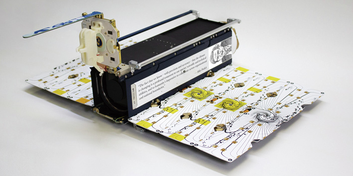
Fig. 3. Planet’s Dove satellites, measuring 10 cm × 10 cm × 30 cm before solar panel deployment, capture images with 3–5 m ground resolution. Changes detected in specific regions of interest can then be zoomed in on with one of Planet’s 50 cm resolution SkySat satellites. Credit: Planet Labs (public domain).
Among the handful of satellite companies Planet has acquired over the past five years is Terra Bella [21], whose constellation of 21 SkySat satellites capture images at up to 50 cm as many as 12 times per day [22]. Planet’s offerings that combine low- and high-resolution imagery allow its more than 700 customers to detect changes anywhere on the planet and then zoom in on specific regions of interest, all within a single platform.
Earth-observing satellites can also capture data outside the visible-light spectrum, using ‘‘active” sensors that provide their own energy source for illumination. Compared to optical satellite imagery, which can only be acquired during daylight hours, active sensors—including light detection and ranging (LiDAR) and synthetic aperture radar (SAR)—can obtain measurements day or night.
LiDAR uses laser radar to transmit light pulses down to the planet’s surface. The distance to objects below is then determined by recording the time between the transmitted and backscattered pulses. LiDAR is particularly well-suited to capture data in dense fields, allowing, for example, the mapping of forest canopies and the underlying topography.
SAR instruments transmit electromagnetic pulses toward the Earth, where they are then reflected back by surface features. Subsequent processing takes the intensity of the returned pulse and the time taken to arrive back at the antenna and turns those data into images. The frequency of the electromagnetic pulses SAR uses is not absorbed by atmospheric features such as clouds, fog, smoke, and rain, enabling visibility through all weather conditions.
SAR imagery has been widely used by the military since the 1970s. But only in the past five years has it become commercially available. Today, companies like Airbus and Lockheed Martin offer a wide range of access to SAR imagery in 50 cm ground resolution to assess, among other things, properties of surface materials such as concrete and asphalt, moisture content of soil, and glacier retreat. Capella (San Francisco, CA, USA) recently announced plans to launch the first of its industry-leading 21 cm-resolution SARcapable Acadia satellites in 2023 [23]. Users can also access free 5 m ground resolution SAR data from two satellites of the European Space Agency’s Sentinel-1 SAR mission [4].
‘‘I do not see much increase in terms of optical-imagery resolution, just based on the limits of physics,” Weeden said. ‘‘But radar and hyperspectral imaging are in their infancy when it comes to the commercial sector. That is where I expect the most innovation to occur.”
Companies do not have to design, build, or launch satellites to get in on the growing remote-sensing market. In the past decade, a cottage industry of hundreds of aggregators and resellers with deals to service certain markets has sprung up. These firms negotiate contracts with multiple providers to offer customers access to datasets at cheaper prices.
Other industries are springing up, too, to support the flood of Earth-observation data hitting the market. Amazon and Microsoft, for example, have both announced plans to build large networks of ground stations around the world, with the hopes that hosting the terabytes of satellite data beamed down to Earth every day will boost the bottom lines of their cloud services [24]. In addition, some companies now specialize in developing software that blends data from different imaging modalities to paint a multi-layered view of regions of interest. Others are focused on creating sophisticated, artificial intelligence-driven analytics packages that can scour satellite imagery databases to quickly find patterns that would escape human recognition [11,15,25–27].
‘‘For us, it is not just the imagery that is useful, but deriving from that algorithms that can identify, for example, building locations, building heights, and types of neighborhoods, as well as land use,” said Andrew Tatem, professor of spatial demography and epidemiology at the University of Southampton in the United Kingdom. Tatem uses data about buildings to estimate population in places where censuses are unreliable. ‘‘Planet and other companies have realized the power of not just providing imagery but extracting custom data from those images.”
Even if much of the remote-sensing data being generated is too difficult for people to comprehend without algorithmic assistance, there will no doubt be a growing demand for satellite imagery, Weeden said. ‘‘It is like the Global Positioning System,” Weeden said. ‘‘The US military had no idea 50 years ago, when they started working on it, that one day you were going to be able to put a little tracking chip in your pet’s collar to follow them around. Likewise, the increasing availability of commercial imagery and other types of remote sensing is enabling NGOs to do things they had never thought possible.”


 京公网安备 11010502051620号


