
In 2023, oceanographers will deploy hundreds of free-drifting robotic floats equipped with sets of custom-built sensors engineered to measure multiple biogeochemical (BGC) characteristics of the world’s oceans, including pH, oxygen, nitrate, and chlorophyll levels. The project, BGC-Argo, piggybacks off the success of the international Argo program, which over the last 20 years has tracked the temperature and salinity of the planet’s oceans with thousands of autonomous cylindrical robotic floats (Fig. 1). With the addition of fleets of more advanced deep water and BGC-Argo floats, the program’s researchers and collaborators aim to answer more complex and vital questions about the ocean’s productivity, carbon cycling, acidification, and ecosystem variability [1].
《Fig. 1》

Fig. 1. Deployment of an Argo float in the Balearic Sea from the French research vessel Pourquoi Pas. Credit: Argo program (public domain).
The ocean generates more than half of Earth’s oxygen [2]. It also minimizes humanity’s impact on the climate; indeed, scientists estimate that the ocean absorbs about a quarter of the CO2 released by human activity [3]. Furthermore, as the Earth warms, most of the extra heat is being trapped in the ocean, which is driving ocean expansion and sea-level rise. However, while the oceans cover nearly 1.4 billion cubic kilometers, or about 71% of Earth’s surface, technical and logistical challenges have limited efforts to understand their dynamics and provide critical data needed to better inform climate and weather models, as well as potential mitigation efforts for global warming [4].
‘‘We need to know what the ocean is doing,” said Ken Johnson, a senior scientist at the Monterey Bay Aquarium Research Institute (MBARI) in California, USA, who oversees the development of some of the BGC-Argo sensors. ‘‘It is three quarters of the planet’s surface, and it is embarrassing how little we observe and understand it.”
To begin to address this deficit and collect information about the geophysical state of the upper portion of the ocean, Argo was launched in 1999 by a handful of US research institutions, including Scripps Institution of Oceanography (SIO) (San Diego, CA, USA), Woods Hole Oceanographic Institution (WHOI) (Woods Hole, MA, USA), and the University of Washington (Seattle, WA, USA). Today, the program includes 34 nation members and operates about 4000 floats, distributed globally, that take measurements throughout the water column’s upper 2000 m.
Considered by many scientists the greatest leap forward in climate observing systems since the emergence of satellites 50 years ago [5], Argo floats are the ongoing result of numerous engineering advances over the program’s two decades [6]. These include materials that have allowed for a significant shrinking and lightening of the float’s casing; a sixfold extension in battery life; high-speed, two-way communications equipment that cuts the time needed to relay data to satellites from 12 h to 20 min and allows for operators to change mission parameters; an algorithm that uses temperature data to prevent floats in the Arctic Ocean from hitting ice at the water’s surface; and upgrades to Argo data management including higher quality metadata.
In May 2022, in recognition of its enabling, through its engineering innovations, ‘‘large-scale autonomous observations in oceanography,” the Argo program received the Institute for Electrical and Electronics Engineers Corporate Innovation Award [7]. Several individuals have also been recognized with awards for their work related the program’s development and implementation. These include Dean Roemmich [8], professor of climate sciences at SIO, and Susan Wijffels [9], senior scientist at WHOI (American Meteorological Society’s 2007 Sverdrup Gold Medal and 2023 Henry Tommel Research Medal, respectively), and Steve Piotrowicz, deputy director of National Oceanic and Atmospheric Administration’s (NOAA) National Office for Integrated and Sustained Ocean Observations at the time of his death in 2018, and NOAA oceanographers Molly Baringer, Claudia Schmid, and Gregory Johnson (NOAA Administrator’s Award) [10]. Piotrowicz also received the 2018 Alexander Agassiz Medal from the US National Academy of Sciences for his contributions to the field of oceanography and his leadership in the creation of Argo [11].
The standard autonomous Argo floats park themselves at a target depth of 1000 m and drift with the ocean currents. Every ten days, the 2 m tall floats descend to 2000 m and collect a vertical profile of temperature and salinity during their ascent back to the surface (Fig. 2). ‘‘Batteries are our limiting factor, so we cycle every ten days to make the instruments last as long as possible,” said Steven Jayne, WHOI senior scientist. ‘‘But even if they had an infinite energy supply, the sensors degrade over time—ten-day cycles are the sweet spot.”
《Fig. 2》
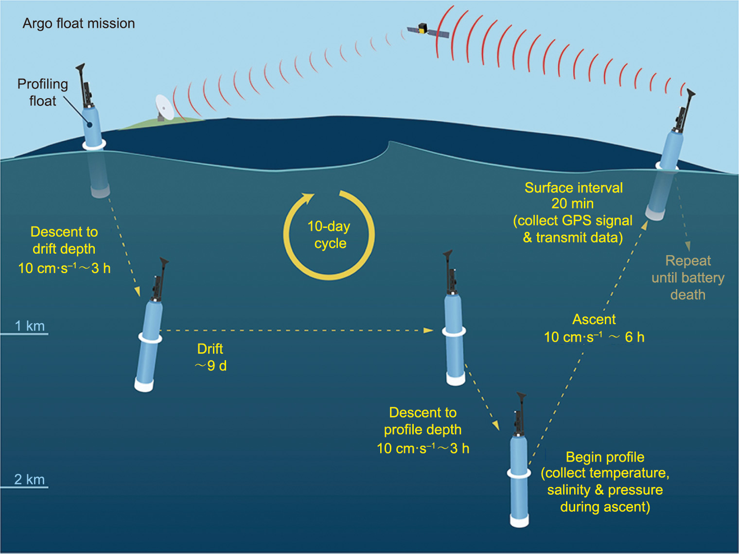
Fig. 2. An illustration of the standard Argo ‘‘park-and-profile” mission. For nine days, the floats drift at a depth of 1000 m. On the tenth day, they descend to 2000 m and collect a vertical profile of temperature and salinity during their ascent back to the surface. Upon surfacing, the float’s position is determined by the Global Positioning System (GPS) and the float beams its data via satellite to centers across the globe. The float then returns to its target depth and the cycle repeats. Credit: WHOI (public domain).
Upon surfacing, the float’s position is determined by the Global Positioning System (GPS) and the float beams its data via an orbiting network of Iridium 2 satellites to centers across the globe [1]. The float then returns to its target depth and the cycle repeats over its roughly-five-year lifespan. Occasionally, mission operators will send a signal to a float to change its mission—switching to a fiveday cycle, higher-resolution data collection schedule—to capture more information during notable weather events such as tropical cyclones [12].
The Argo float network represents a huge leap forward over historical methods of collecting data from ships or buoys. Performing a 2000 m temperature and salinity profile from a research vessel could take hours and changing locations could take days, making global coverage impossible. ‘‘No one wants to sit in the middle of the ocean all year long and just measure stuff over and over again,” Johnson said. ‘‘But the robot floats, they do not care. They sample on Christmas, they sample during hurricanes, they sample when COVID keeps people off boats.”
And while imaging satellites orbiting Earth can lay eyes on every meter of the ocean’s surface, most only see what happens to a depth of several meters, with a much smaller number that can penetrate the surface tens of meters [1]. Satellite data, however, are often analyzed alongside Argo data. ‘‘The floats obviously do not have the spatial coverage of the satellites,” said Mariana Bif, research specialist in the chemical sensors group at MBARI. ‘‘We use both of them together—the satellites for horizontal coverage and the floats for vertical coverage.”
The global Argo fleet annually provides 100 000 temperature and salinity profiles to researchers and weather forecasters worldwide, free of charge. To date, these measurements have contributed to more than 5000 published academic articles and 250 doctoral theses, Johnson said, and they comprise a major component of the Global Ocean Observing System, a global monitoring system administered by the Intergovernmental Oceanographic Commission of the United Nations Educational, Scientific and Cultural Organization.
Among notable Argo findings are that, compared with historical data, there has been a distinct increase in salinity in salty areas and a decrease in salinity in less salty areas [13] and that the upper 2000 m of the ocean has captured roughly 90% of the anthropogenic change in ocean heat content over the last few decades [14]. One of the key contributions of Argo, said Jayne, is an understanding of how much the ocean is expanding and how that affects the ocean’s ability to absorb and release heat at sea level. Deep Argo, an extension of the core program, is intended to provide further understanding of this process. Over the next several years, this new project will deploy hundreds of floats engineered to operate at depths down to 6000 m. ‘‘Some of the extra heat generated as a result of increased CO2 levels gets trapped below where core Argo measures,” Johnson said. ‘‘To measure that heat, you need to go deep.”
The Deep Argo floats have a glass-sphere design (Fig. 3) to withstand the far greater pressures they will experience. The salinity sensors have been reengineered, as well, to account for the increased compression at depths down to 6000 m.
《Fig. 3》
Fig. 3. Deep Argo floats, meant to measure temperature and salinity as deep as 6000 m, have been reengineered with a spherical glass casing to withstand the intense pressures at greater depths. Credit: MRV Systems (public domain).
Another major expansion of the Argo program includes deployment of the BGC floats. More than 450 floats with one or more BGC sensors have been deployed since 2014 via the Southern Ocean Carbon and Climate Observations and Modeling (SOCOM) program and the Global Ocean Biogeochemistry program, both funded by the US National Science Foundation (NSF). The latest floats include up to eight sensors to measure temperature, salinity, pH, oxygen, nitrate, sunlight (downwelling irradiance), chlorophyll (an indicator of ocean plant life), and suspended particles (including macroalgae and bacteria) [15]. Program scientists hope to use these most advanced BGC floats to learn, among other things, how and why the ocean is losing oxygen and to better understand the production of organic carbon by photosynthesis and the biological pumping of that carbon to the deep ocean.
While the skeleton of the BGC floats is the same as the core cylindrical Argo floats, the BGC sensors themselves are complex and novel—off-the-shelf sensors were not an option. ‘‘Most chemical instruments require solutions, which we cannot add to the floats, and that limits the types of sensors we can use,” Bif said.
‘‘For nitrate sensors, for example, everybody thinks about a device that just measures nitrate,” Johnson said. ‘‘But it is actually an exercise in combining data from multiple sensors because the absorption of light by nitrate depends on pressure, temperature, and salinity. The same goes for oxygen; the sensor depends on pressure, temperature, and salinity. You need to account for all of that to get your measurement.”
Cramming in the new sensors has also proved challenging. The temperature and salinity sensors aboard the core Argo floats occupy the top fifth of the device, with the rest devoted to controllers, batteries, a satellite transmitter, and parts such as pumps and bladders that allow the float to control its depth. For the BGC floats, engineers had to figure out how to fit the additional sensors into the few empty spaces within and sometimes outside the cylindrical casing (Fig. 4). In addition, because the sensors’ readings are so intricately connected and there is some variation across floats in terms of design, the exact distance sensors are from one another is tracked in each float’s metadata.
《Fig. 4》
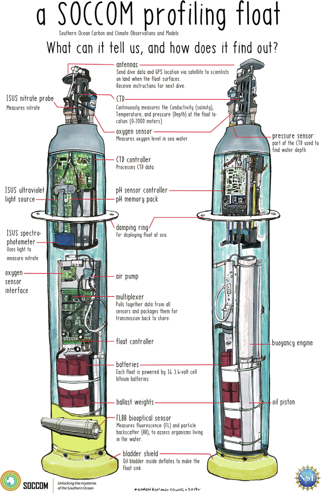
Fig. 4. Using the same skeleton at the core Argo floats (right), and outfitted with the same temperature and salinity sensors, researchers have engineered BGC floats (left) with an array of sensors to measure pH, oxygen, nitrate, sunlight, chlorophyll, and suspended particles. Credit: SOCOM (public domain).
Sensor calibration poses another major challenge. ‘‘The hardest part of Argo, in a way, is that we deploy these instruments and then we never see them again,” Jayne said. ‘‘A lot of chemical sensors are based off the fact that you can occasionally calibrate them. If you never get it back, you can never check the calibration. The sensors we use are built to be very stable over time.”
Still, sensors falling out of calibration is a serious issue. ‘‘The sensors are not perfect. They can drift,” said Johnson. ‘‘We are looking for tiny signals, and no one wants to write a paper about the ocean losing oxygen because the sensor is drifting.”
In the case of oxygen, when the float comes to the surface, it sticks its sensor up in the air to measure atmospheric oxygen levels to recalibrate. In addition, researchers use data collected from ships and satellites to calibrate float data. They also use machine learning techniques to compare sensor readings across floats and to historical trends and other data sources to identify floats that may be out of calibration and apply offsets to the data [16,17].
As of November 2022, 469 floats with at least one BGC sensor were operating around the globe. While just 22 of those carried the full suite of sensors, the NSF is paying to build and deploy a total of 500 fully loaded BGC floats over the next five years, half of the planned international array of 1000. More than a dozen other mostly European and Asian nations, including China, have committed to filling out the rest of the BGC-Argo armada. Keeping all the pieces in place and moving forward offers its own challenges. ‘‘Building and maintaining international partnerships is an ongoing endeavor,” Johnson said. ‘‘Nobody ever trains you in graduate school on international negotiation protocols, but it is a big part of this work.”
Ideally, Jayne said, the program’s administrators believe a global fleet of 3000 core, 1000 deep, and 1200 BGC floats will provide an adequate level of spatial coverage to track global ocean dynamics. ‘‘There has been a lot of thought put into how to build what we are calling ‘One Argo’ to comprehensively cover the ocean,” Jayne said. ‘‘However, the money has not come in to do it quite yet.”
Because each autonomous float has a life of about four to six years, the program must deploy new floats every year to keep the population steady. Lifetime costs run about 30 000 USD for a core float and about 83 000 USD for a Deep Argo version; the more complicated sensors onboard the fully loaded BGC floats can push their cost to 100 000 USD, Johnson said.
Data from the existing array of BGC floats have already led to more than 300 published research papers over the last few years covering a range of topics [18], including the annual amount of atmospheric carbon captured by phytoplankton [19] and identifying global zones of oxygen depletion [20]. BGC-Argo data captured during abnormal weather events has also allowed researchers to assess the impact of extreme weather events, such as 2018’s Typhoon Trami on plankton growth [21] and the impact of marine heatwaves on ocean mixing in the Pacific [22].
Despite the significant upgrade the expanded set of BGC sensors represents to the Argo mission, program scientists and engineers hope to develop additional sensors to measure, among other things, alkalinity (to better understand the ocean’s pool of inorganic carbon), turbulence (to learn more about how the ocean mixes), and the DNA of plankton and other microorganisms (to better characterize the spatial and temporal dynamics of species distribution). ‘‘We are constantly looking at improving the floats,” Jayne said. ‘‘If we can make the existing floats last longer and do more things, we do not necessarily need a lot more money coming into the program to maintain and, even better, enhance their capabilities.”


 京公网安备 11010502051620号


