2008, Volume 10, Issue 9
Strategic Study of CAE >> 2008, Volume 10, Issue 9
Advances on the application of ocean color remote sensing engineering in China
State Key Laboratory of Satellite Ocean Environment Dynamic,Second Institute of Oceanography, State Oceanic Administration, Hangzhou 310012, China
Next Previous
Abstract
After many years' endeavor of research and application practice, the ocean color remote sensing in China has been growing into a new technique with valuable practicality from the initiate stage of trial research. With the aim of operational service, several kinds of ocean color remote sensing monitoring systems have been developed, and realized the long-term marine environmental monitoring dynamically utilizing the real-time or near real-time satellite data and airborne remote sensing data. In this paper, firstly, four major technical advances are describing, including 1) the radiative transfer principle of the ocean color remote sensing; 2) the atmospheric correction algorithms specialized on China Sea and Chinese ocean color satellites; 3) ocean optical research in China Sea and the study of semi-analysis algorithm of inherent optical properties; 4) local algorithms of oceanic parameters. Secondly, On the foundation of technical advances, ocean color remote sensing takes effect on marine environment monitoring, with four major kinds of application systems, namely, 1) the automatic multi-satellites data receiving, processing and application system; 2) coastal water quality monitoring and fast report system; 3) the shipboard satellite data receiving and processing system; 4) the preliminary system of airborne ocean color remote sensing application system. Finally, according to the application status and requirements, the prospective development of Chinese ocean color remote sensing is brought forward. With Chinese second ocean color satellite (HY-1B) orbiting on April 11, 2007 and the development of airborne ocean color remote sensing system for Chinese Surveillance Planes, great strides will take place in Chinese ocean color information application with the unique function in the field of marine monitoring, resources management and national security, etc.
Keywords
ocean color remote sensing ; operational application system ; Chinese ocean color satellite series ; HY-1A/B
Figures
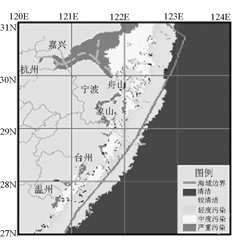
图1
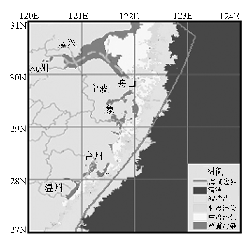
图2
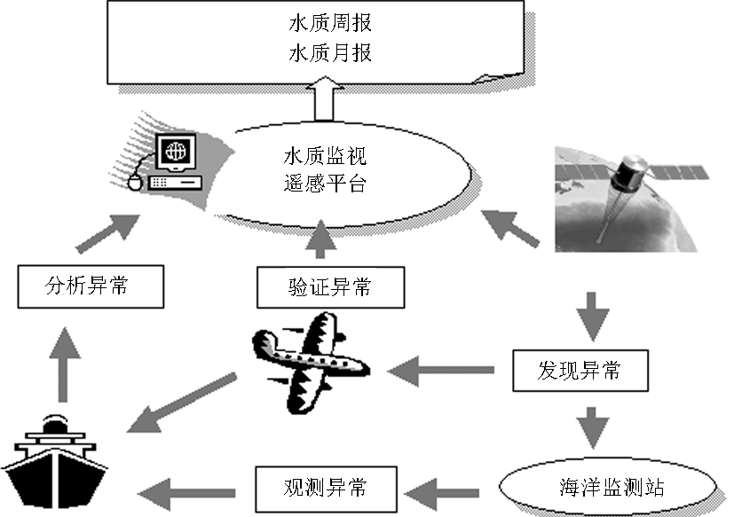
图3
References
[ 1 ] 潘德炉,王迪峰.我国海洋光学遥感应用科学研究的新进展[J].地球科学进展,2004,19(4):506-512 link1
[ 2 ] 潘德炉,何贤强,李淑菁,等.我国第一颗海洋卫星HY-1A的应用潜力研究[J].海洋学报,2004,26(2):37-44 link1
[ 3 ] Stamnes K, Tsay S C, Wiscombe W, et al.Numerically stable al- gorithm for discrete - ordinate -method Radiative transfer in mul- tiple scattering and emitting layered media [ J ] . Appl. Opt., 1988 , 27 : 2502 -2509 link1
[ 4 ] Mobley C D.Light and water: radiative transfer in natural water [ M] .Academic Press, San Diego, 1994
[ 5 ] Jin Z, Stamnes K.Radiative transfer in nonuniformly refracting layered media: Atmosphere - ocean system [ J ] .Appl.Opt., 1994 , 33 : 431 -442 link1
[ 6 ] Fell F, Fischer J.Numerical simulation of the light field in the at- mosphere -ocean system using the matrix -operator method [ J] . J.Quant.Spect.Rad.Trans., 2001 , 69 : 351 -388 link1
[ 7 ] 唐军武,田国良,陈清莲.离水辐射非朗伯特性的 Monte Carlo 模拟及分析[J].海洋学报,2000,22(2):48-57 link1
[ 8 ] 段民 征, 吴 北 婴, 吕 达 仁.海 洋 -大 气 耦 合 辐 射 传 输 模 式 [ J] .大气科学,1997 ,21 ( 6 ) : 734 -742 link1
[ 9 ] 张鉴,何晓雄,赵凤生.利用大气-海洋系统辐射传输模拟水色遥感信息量的变化特性[J].量子电子学报,2003,20(5):623-628 link1
[10] 何贤强,潘德炉,朱乾坤,等.基于矩阵算法的海洋-大气耦合矢量辐射传输数值计算[J].中国科学D辑,2006,36(9):860-870 link1
[11] Pan Delu, Mao Zhihua. Atmospheric correction for Chinese coastal water color remote sensing [ J ] .Acta Oceanol.Sinica, 2001 , 20 ( 3 ) : 343 -354 link1
[12] 毛志华,黄海清,朱乾坤,等.我国海区SeaWiFS资料大气校正[J].海洋与湖沼,2002,32(6):581-587 link1
[13] 韦钧,陈楚群,施平.一种可适用于二类水体的SeaWiFS资料大气校正方法[J].海洋学报,2002,24(4):118-125
[14] Li Y.Atmospheric correction of SeaWiFS imagery for turbid coastal and inland waters: comment [ J ] .Appl.Opt., 2003 , 42 : 893 -895 link1
[15] 丁静,唐军武,宋庆君,等.中国近岸浑浊水体大气修正的迭代与优化算法[J].遥感学报,2006,10(5):732-741 link1
[16] He Xianqiang, Pan Delu, Mao Zhihua.Atmospheric correction of SeaWiFS imagery for turbid coastal and inland waters[ J] .Ac- ta Oceanologica Sinica, 2004 , 23 ( 4 ) : 609 -615
[17] 何贤强,潘德炉,朱乾坤,等.海洋水色及水温扫描仪精确瑞利散射计算[J].光学学报,2005,25(2):145-151 link1
[18] 何贤强.海洋-大气耦合矢量辐射传输计算模型研究及其在中国海洋水色系列卫星中的应用[D].北京:中国科学院.2007
[19] 何贤强,潘德炉,白雁,等.通用型海洋水色遥感精确瑞利散射查找表[J].海洋学报,2006,28(1):47-55 link1
[20] 朱建华,李铜基.黄东海海区浮游植物色素吸收系数与叶绿素a浓度关系研究[J].海洋技术,2004,23(4):117-122. link1
[21] 朱建华,李铜基.黄东海非色素颗粒与黄色物质的吸收系数光谱模型研究[J].海洋技术,2004,23(2):7-13 link1
[22] 王晓梅,唐军武,宋庆君,等.黄海、东海水体总吸收系数光谱特性及其统计反演模式研究[J].海洋与湖沼,2006,37(3):256-263 link1
[23] 彭海龙,孙从容,张正,等.黄、东海区光谱漫衰减系数特性研究[J].海洋通报,2004,23(4):15-18 link1
[24] 李铜基,陈清莲,杨安安,等.黄东海春季水体后向散射系数的经验模型研究[J].海洋技术,2004,23(3):11-14 link1
[25] 宋庆君,唐军武,马超飞.黄东海区水体后向散射系数与总散射系数的关系[A].第14届全国遥感技术学术交流会[C].青岛,2003,10 link1
[26] 宋庆君,唐军武.黄海、东海海区水体散射特性研究[J].海洋学报,2006,28(4):56-61 link1
[27] 汪小勇,李铜基,杨安安.黄东海海区表观光学特性和固有光学特性春季模式研究[J].2004,23(4):123-126 link1
[28] 李铜基,朱建华,陈清莲.黄东海海区春季半经验分析生物-光学算法研究[J].海洋技术,2006,25(1):83-88 link1
[29] 孙从容,唐君武,彭海龙.黄东海海水体类型综合识别技术研究[J].海洋预报,2005,22(2):7-14 link1
[30] 白雁.中国近海固有光学量及有机碳卫星遥感反演研究[D].北京:中国科学院.2007
[31] 唐军武,王晓梅,宋庆君,等.黄东海二类水体水色要素统计反演模式[A].第14届全国遥感技术学术交流会[C].2003 link1
[32] 黄海清,何贤强,王迪峰,等.神经网络法反演海水叶绿素浓度的分析[J].地球信息科学,2004,6(2):31-36 link1
[33] 詹海刚,施平,陈楚群.基于遗传算法的二类水体水色遥感反演[J].遥感学报,2004,8(1):32-26 link1
[34] 沈春燕,陈楚群,詹海刚.人工神经网络反演珠江口海域叶绿素浓度[J].热带海洋学报,2005,24(6):38-43 link1
[35] 杨燕明,刘贞文,陈本清,等.用偏最小二乘法反演二类水体的水色要素[J].遥感学报,2005,9(2):123-130 link1
[36] 廖迎娣,张玮, Deschamps P Y.运用 SeaWiFS 遥感数据探测中国东部沿海悬浮泥沙浓度的研究[J].水动力学研究与进展,2005,A辑,20(5):558-564 link1
[37] 陈晓翔,丁晓英.用FY—1D数据估算珠江口海域悬浮泥沙含量[J].中山大学学报(自然科学版),2004,43(增刊):194-196 link1
[38] Chen Chuqun, Shi Ping, Yin Kedong ,et al.Absorption coeffi- cient of yellow substance in the Pearl River estuary [ J ] .Proc. SPIE 2003 , 4892 :215 -221 link1
[39] 马超飞,蒋兴伟,唐军武,等.HY-1/CCD宽波段水色要素反演算法[J].海洋学报.2005,27(4):38-44. link1
[40] 唐军武,丁静,田纪伟,等.黄东海二类水体三要素浓度反演的神经网络模型[J].高技术通讯,2005,15(3):83-88
[41] 王晓梅,唐军武,丁静,等.黄海、东海二类水体漫衰减系数与透明度反演模式研究[J].海洋学报,2005,27(5):38-45 link1
[42] 何贤强,潘德炉,毛志华,等.利用Sea WiFS反演海水透明度的模式研究[J].海洋学报,2004,26(5):55-62 link1
[43] 何贤强,潘德炉,黄二辉,等.中国海透明度卫星遥感监测[J].中国工程科学,2004,6(9):33-37 link1
[44] 宁修仁,史君贤,蔡昱明,等.长江口和杭州湾海域生物生产力锋面及其生态学效应[J].海洋学报,2004,26(6):96-106 link1
[45] 李国胜,王芳,梁强,等.东海初级生产力遥感反演及其时空演化机制[J].地理学报,2003,58(4):483-493 link1
[46] Pan Delu, Guan Wenjiang, Bai Yan, et al.Ocean primary pro- ductivity estimation of China Sea by remote sensing[ J] .Progress in Natural Science, 2005 , 15 ( 7 ) : 627 -632 link1
[47] 官文江,何贤强,潘德炉,等.渤、黄、东海海洋初级生产力的遥感估算[J].水产学报,2005,29(3):367-372 link1
[48] Bai Yan , Pan Delu , He Xianqiang , et al.Ocean primary pro- duction estimation of China Bohai Sea and Yellow Sea by HY - COCTS[ J] .Proc.of SPIE, 2005 , 5977 , 597704 link1
[49] 张穗,何报寅.河口Ⅱ类水体富营养化的遥感定量方法研究[J].长江科学学院院报,2004,21(3):29-31 link1
[50] 张霄宇,林以安,唐仁友,等.遥感技术在河口颗粒态总磷分布及扩散研究中的应用初探[J].海洋学报,2005,27(1):51-56 link1
[51] 李小斌,陈楚群,施平,等.2007.珠江口海域总无机氮的遥感提取研究[J].环境科学学报,27(2):313-318 link1
[52] Callahan Julie, Dai Minhan, Chen Robert F, et al.Distributionof dissolved organic matter in the Pearl River Estuary, China [ J] .Marine Chemistry, 2004 ( 89 ) : 211 -224 link1
[53] Che Zhiqiang, Li Yan, Pan Jianming.Distributions of colored dissolved organic matter and dissolved organic carbon in the Pearl River Estuary, China [ J ] . Continental Shelf Research, 2004 ( 24 ) : 1845 -1856 link1
[54] Zhang Xiaoyu, Pan Delu.Remote monitoring of eutrophication parameters with basic ecological models [ J ] .Proc.of SPIE. 2005 , 5832 : 461 -470 link1
[55] Zhang Xiaoyu, He Xianqiang, Pan Delu.Forecast and real time monitor of algal bloom in Chinese coast using MODIS ocean color imagery[ J] , Proc.of SPIE.2005 , 5832 : 493 -501 link1
[56] 王其茂,马超飞,唐军武,等.EOS/MODIS遥感资料探测海洋赤潮信息方法[J].遥感技术与应用,2006,21(1):6-10 link1
[57] 唐军武,丁静,王其茂,等.大气散射对采用归一化植被指数进行赤潮遥感监测的影响研究[J].海洋学报,2004,26(3):136-142 link1
[58] 赵冬至,张丰收,杨建洪,等.表征赤潮水体太阳激发的叶绿素荧光高度的波段优化———归一化荧光高度法[J].海洋学报,2005,27(6):146-153 link1
[59] 王曙光.2003年中国海洋卫星应用报告[M].国家海洋局,2004
[60] 罗亚威,张蕴斐,孙从容,等.“海洋1号”卫星在海冰监测和预报中的应用[J].海洋学报,2005,27(1):7-17 link1
[61] Wang Difeng, He Xianqiang, Gong Fang, et al .The design and construction of a satellite data processing system for marine appli- cation[ J] .Proceedings of SPIE.2004 ,5570 :602 -611 link1
[62] Wang Difeng, Gong Fang, He Xianqiang, et al.Design and con- struction of a satellite data processing system ( SatDPS) for ma- rine application[ J ] .Proceedings of SPIE, 2005 , 5832 : 652 - 661 link1
[63] Pan Delu, Zhang Xiaoyu, Huang Haiqing, et al.Preliminarily study on coastal water quality classification by satellite data[ J] . Proc.of SPIE,2006 , 6406 , 64060F. link1
[64] 潘德炉,李炎.海洋光学遥感技术的发展和前沿[J].中国工程科学,2003,5(3):39-43 link1
[65] Mao Zhihua, Zhu Qiankun, Pan Delu.Development of an opera- tional fisheries oceanography system of North Pacific Fishery[ J] . Proceedings of SPIE,2004 , 5233 :314 -321 link1
[66] 毛志华,朱乾坤,龚芳.卫星遥感北太平洋渔场叶绿素a浓度[J].水产学报,2005,29(2):270-274 link1
[67] 范学炜,张汉德,孙幸文.成像高光谱数据在赤潮检测和识别中的应用研究[J].国土资源遥感,2003,1(55):8-12 link1
[68] 王迪峰,于龙,龚芳,等.机载多光谱扫描仪及其海洋遥感信息获取的潜力[J].仪器仪表学报,2005,26(8)增刊:585-588 link1
[69] Difeng Wang, Delu Pan, Fang Gong, et al.Inflight experimenta- tion and preliminary marine application of AISA + in Chinese coastal zone[ J] .Proc.of SPIE, 2006 , 6405 , 640521 link1
[70] 蒋旭惠,陈性义,赖祖龙,等.海洋航空遥感多传感器应用系统集成[J].测绘工程,2007,16(1):47-50 link1
[71] 赵艳玲,何贤强,王迪峰,等.基于Web海洋卫星遥感产品的查询系统[J].东海海洋,2005,23(1):32-39 link1
[72] 王舒境,刘仁义,刘南,等.面向分布式异构数据库的海洋遥感WebGIS研究[J].浙江大学学报(理学版),2006,33(6):702-706 link1
[73] Pan Delu.Future -generation satellites of Chinese ocean remote sensing[ J] .Proceedings of SPIE, 2004 ,5570 : 228 -232 link1


 京公网安备 11010502051620号


