
《1. Introduction 》
1. Introduction
In 2018, the Australian Commonwealth Government committed 224.9 million AUD (160 million USD) to the Positioning Australia program in order to provide 10 cm accurate and reliable positioning to all Australians and accelerate the adoption and development of positioning technology and applications. This is a significant improvement from the 5–10 m accuracy that can currently be achieved using consumer positioning devices. Geographically speaking, Australia is in the position to take advantage of highquality, accurate, and efficient space-based positioning constellations with view of all global and regional constellations, including those of the United States (Global Positioning System, GPS), Russia (Global Navigation Satellite System, GLONASS), the European Union (Galileo), China (BeiDou), Japan (Quasi-Zenith Satellite System, QZSS), and India (Indian Regional Navigation Satellite System, IRNSS).
This funding commitment is an implicit acknowledgement that geodesy is no longer an esoteric science. Thanks to geodesy, we can compute where we are on the Earth, determine where things are located around us, and align spatial data to make better decisions. Geodesy is relied upon for myriad social, environmental, and economic initiatives. In addition to the traditional survey, mapping, and navigation fields, geodetic applications are increasingly critical for civil engineering, industrial automation, agriculture (e.g., Syifa et al., this issue), construction, mining, recreation, financial transactions, intelligent transport systems, disaster response and emergency management (e.g., Baek and Jung, this issue), environmental studies, and scientific research.
By 2023, location-based services (e.g., augmented reality and emergency services) and intelligent transport services (road, rail, maritime, and aviation) are expected to account for 93.5% of Global Navigation Satellite System (GNSS) chipset sales [1]. Furthermore, the Australian economy is estimated to grow by an additional 73 billion AUD (52 billion USD) by 2030, due to augmented positioning [2]. This growing user base of non-specialist users expects real-time, accurate, and high-integrity positioning services and applications. These users should not be expected to deal with the complexities of coordinate transformations, coordinate conversions, datums, and geoid models. The challenge for governments and spatial professionals is to develop high-quality and robust infrastructure, tools, services, and communication services, which will enable industry, scientists, and the public to capitalize on this technology and maximize its benefit.
Through the implementation of the Positioning Australia program, Geoscience Australia is aiming to fill some of these gaps and accelerate the adoption of positioning technology and applications in Australia. By enhancing the access, accuracy, and reliability of positioning, we will enable innovative technologies across a range of industries and accelerate economic growth. This will be done by completing a range of projects, which are described below.
《2. Positioning Australia 》
2. Positioning Australia
The Positioning Australia program is working to ensure that accurate positioning information is widely available to the Australian community. This is being delivered through two complementary projects: a national network of ground station infrastructure and GNSS analysis software (see below), and a system to deliver corrected positioning signals directly to Australians via satellite technology through a Satellite-Based Augmentation System (SBAS).
An SBAS overcomes current gaps in mobile and radio communications and, when combined with our national infrastructure network, ensures that accurate positioning information can be received. The SBAS augments and corrects GNSS signals to improve the accuracy of positioning data and makes it available across Australia and its maritime zones without the need for mobile phone or internet coverage.
In February 2020, Australia and New Zealand entered into a partnership to jointly deliver the SBAS component of the program. This will be the first such system in the Southern Hemisphere, and will be called the Southern Positioning Augmentation Network.
Current technology typically allows for positioning within 5– 10 m accuracy; through this program, however, the accuracy will be improved to within 3 cm in areas with mobile phone coverage and to within 10 cm everywhere else. This will deliver accurate, reliable, and instantaneous positioning across Australia and its maritime zones (Fig. 1). Together, these programs will provide more reliable positioning information, allowing for innovation and efficiency across a range of industries such as agriculture, transport, emergency management, mining, engineering, and logistics.
《Fig. 1》

Fig. 1. Users will be able to receive accurate and reliable positioning information from ground-based and satellite-based platforms. Source: Geoscience Australia.
《3. Densification of GNSS infrastructure》
3. Densification of GNSS infrastructure
To ensure that Geoscience Australia is able to provide highquality positioning corrections across the continent, 64 million AUD (46 million USD) is dedicated to upgrading and expanding Australia’s ground network of GNSS infrastructure. A network of approximately 200 government-operated multi-GNSS ground stations will be densified with over 500 third-party ground stations to generate open-access, centimeter-accurate positioning corrections available over mobile internet (when in a coverage area). Geoscience Australia will also establish a GNSS data center to monitor the GNSS network and to archive and distribute data and services to users from a variety of different sectors, including system integrators and innovators. The network upgrade will be completed by June 2022.
《4. Development of open-source real-time positioning software and products》
4. Development of open-source real-time positioning software and products
To encourage the uptake and innovation of Positioning Australia’s accurate and reliable positioning, navigation, and timing services, Geoscience Australia is developing and releasing multi-GNSS analysis software that is capable of managing the acquisition, processing, and delivery of multi-GNSS data and related products.
This capability will comprise the following components:
(1) A network platform that accepts carrier, code, and ranging observation data to enable the computation of high-accuracy orbits, clocks, satellite phase biases, and atmospheric models, as well as station coordinates.
(2) A user platform that accepts high-accuracy orbits, clocks, satellite phase biases, and atmospheric models in addition to carrier and code observation data to enable single-receiver users to compute high-accuracy positions.
(3) A combination platform that accepts parameter estimates and their variance–covariance information to enable the combination of geodetic solutions including combining station coordinates into multi-day solutions, combining station coordinates into multiyear solutions with the estimation of station velocities, and performing time series analysis.
The first version of the software was delivered in June 2018. Geoscience Australia will continue the subsequent software development and anticipates having a suite of open-source software capable of processing satellite data and delivering high-accuracy and real-time positioning data by June 2022.
《5. Upgrading the Australian Geospatial Reference System》
5. Upgrading the Australian Geospatial Reference System
The Australian Geospatial Reference System is a collective term used to describe the datums, reference frames, models, infrastructure, and standards needed for accurate and reliable four-dimensional (4D) positioning (Fig. 2).
《Fig. 2》
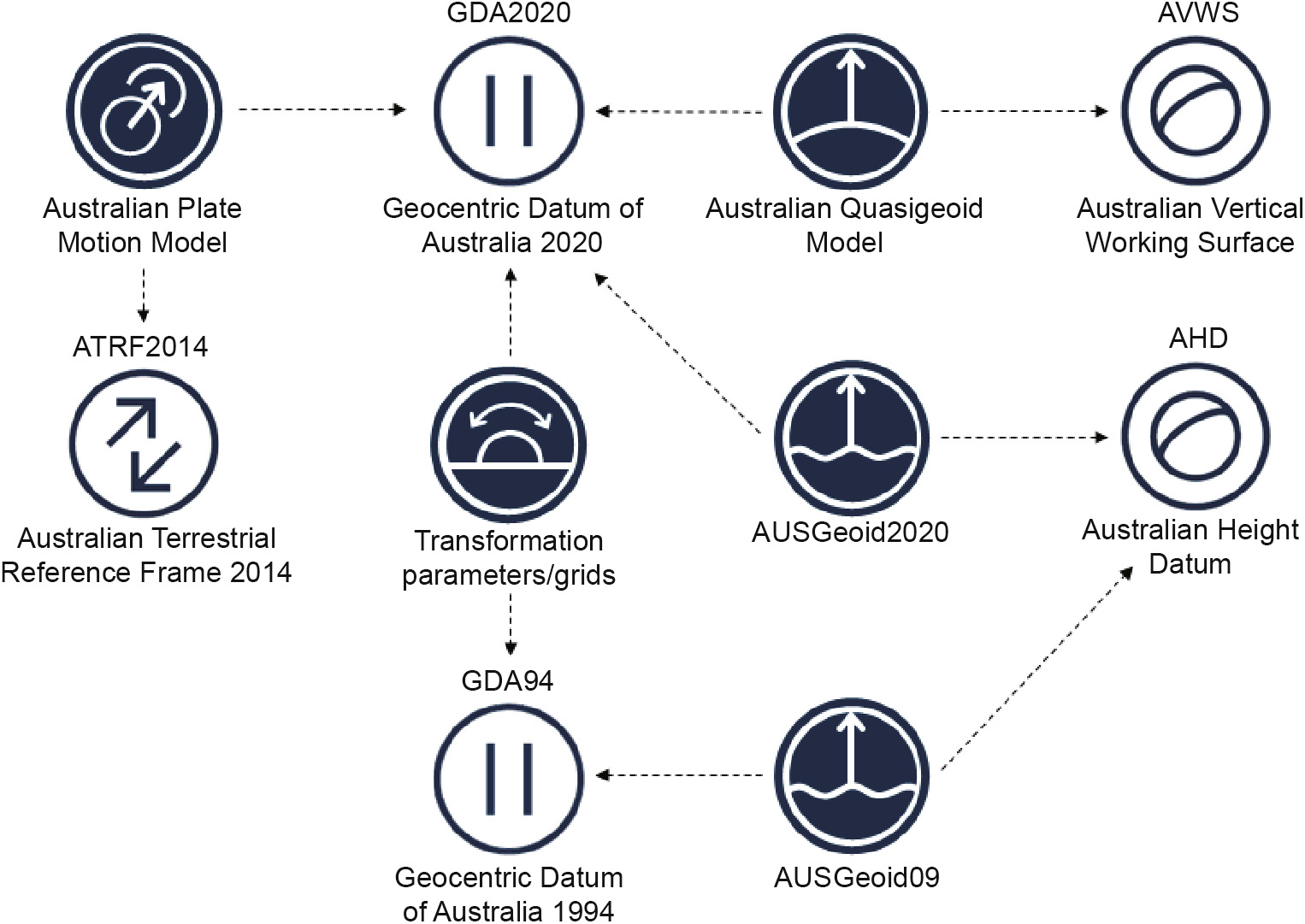
Fig. 2. The Australian Geospatial Reference System is the collective term used to describe the datums, reference frames, models, infrastructure, and standards needed for accurate and reliable 4D positioning. Source: Geoscience Australia.
Maximizing the benefits of the emerging precise positioning technology requires datums or reference frames that are more accurate than the data, closely aligned to reference frames of GNSS, and, in some cases, time-dependent.
In anticipation of these needs, geodetic scientists from Australia’s Commonwealth, state, and territory governments have upgraded a number of elements of Australia’s Geospatial Reference System over the past decade, including upgrading the static datum (from the Geocentric Datum of Australia 1994 (GDA94) to the Geocentric Datum of Australia 2020 (GDA2020)). Australia has also introduced a time-dependent reference frame—the Australian Terrestrial Reference Frame 2014 (ATRF2014)—which is a densified version of the International Terrestrial Reference Frame 2014 [3]. Users are able to propagate between the static GDA2020 and the time-dependent ATRF2014 using a plate motion model, similar to the approach described by Cheng et al. (this issue). Other upgrades to the Australian Geospatial Reference System include a new reference surface for heights—the Australian Vertical Working Surface— and the development of standards to improve the access and efficiency of geodetic data (e.g., GeodesyML) [4]. For more information on aspects of the upgrade, please refer to the Intergovernmental Committee on Surveying and Mapping website [5].
User expectations and technological improvements continue to drive down the uncertainty of positioning data. This in turn highlights the requirement to continually improve the accuracy and integrity of our data and datums. This is a new era for the geodetic community; more people than ever are reliant on the work we do, but just as many do not understand it. This is not to say that they should understand it; in fact, they should be abstracted from it by spatial professionals. It is our role, as these spatial professionals, to improve the technology, understand user requirements, and meet user expectations.


 京公网安备 11010502051620号


