
《1 The significance of the green and circular development in the Qinba Mountains area》
1 The significance of the green and circular development in the Qinba Mountains area
Since the 18th National Congress of the Communist Party of China (CPC), the CPC Central Committee, with Comrade Xi Jinping as General Secretary, has formed a series of new concepts, ideas, and strategies for administering China. These provide scientific theoretical guidance and action for advancing reform and the opening up and acceleration of a socialist modernization agenda under new historical conditions. In order to achieve the developmental goals, solve developmental problems, and improve the developmental advantages in the 13th FiveYear Plan period, China must firmly establish and effectively implement developmental concepts. These include innovation, coordination, green issues, openness, and sharing, and are taken from the principles discussed by the Fifth Plenary Session of the 18th CPC Central Committee.
Based on the goal requirements in Suggestions of the CPC Central Committee on Developing the 13th Five-Year Program for National Economic and Social Development for a universally prosperous society that need to be fully completed in the next five years, China must strive to achieve five new goals. First, the economy must maintain medium- to high-speed growth. In 2020, gross domestic product (GDP) and the average per capita income of urban and rural residents must be double those of 2010. This must be achieved on the basis of improvements that are compatible with balanced, inclusive, and sustainable development. Second, the people’s living standards and quality of life must be generally improved. Greater employment and sounder public service systems are goals that must be achieved, together with improvements in education, culture, social security, medical care, and housing. The equalization of basic public services must be steadily increased. The rural poor, and all the poor counties in China, must be lifted out of poverty and the issue of overall regional poverty must be solved. Third, national quality and social civilization must be improved significantly. The Chinese dream and the socialist core values of the people must take deeper root in China. The impact of Chinese culture must continue to expand. Fourth, the quality of the ecological environment must be improved overall. The production mode and the way of life must be associated with the rise of a green, low carbon environment. The layout of the main functional area and the barrier of ecological security must be formatted in basic terms. Fifth, various aspects of governance systems must be more mature, with more conventional images. Indeed, great progress should be made in the modernization of national governance systems and their capacity. Moreover, the basic system in various fields should been formed.
The Qinba Mountains area is located in the hinterland of China’s geographic center, which covers five provinces and one city of Shaanxi, Sichuan, Hubei, Henan, Chongqing, and Gansu; 20 prefecture-level cities; a Gannan Tibetan Autonomous Prefecture; a Shennongjia Forestry District; and 119 counties (district, county-level city). The total area is 308 634 km2 [1]. The Qinba Mountains area traverses the region from east to west. Both the Hanjiang River and the Danjiang River run through the territory, which has diverse topography, mountain and hill ranges, and widespread basins and valleys. The territory also has fertile soil, a mild climate, many rivers and streams, and crisscrossing paths. The Qinba Mountains area is an important, protected ecological region in the upper reaches of the Yangtze River. It is abundant in sunshine, water, and forests; grass and native products; and mineral and other natural resources. It is also rich in hydropower resources, which are reasonably distributed. In the document National Planning of Main Functional Areas, the Qinba Mountains area is identified as an ecologically diverse conservation area and an important water conservation area in the South-to-North Water Diversion Project in China. The latter is a project for diverting water from the south to the north. Overall, the Qinba Mountains area is a restricted development area where the basic function is to maintain biodiversity, the water, and the soil.
The Qinba Mountains area is a particularly concentrated area of poverty in China. It has collective areas of the old revolutionary base, large reservoirs, and frequently occurring natural disasters. It also has significant internal differences, complex poverty factors, and the most Chinese provincial-level administrative regions (five provinces and one city) among the main areas that are involved in China’s new round of poverty alleviation and development. The development of the Qinba Mountains area will have a lasting influence on the implementation of the national ideas of ecological green transformation, the promotion of a new-type urbanization strategy, the construction of the Silk Road Economic Belt, and further development of the western region.
From 2015, Study on the Green & Circular Development Strategy of the Qinba Mountains has been a major consultation project of the Chinese Academy of Engineering. The project considers the Qinba Mountains area as a whole and proposes the overall thinking and objectives of the green circulation development, through in-depth investigation, careful analysis, and research. The Green and Circular Development Strategy in the Qinba Mountains Area in the Henan Region (the Funiu Mountains) of China is one of the important topics of the project. The Qinba Mountains area in the Henan region consists of the Funiu Mountains, one of the main fields of operation for poverty alleviation. It covers “three mountain regions and one floodplain” (i.e., the Taihang Mountains, the Funiu Mountains, the Dabie Mountains, and the Yellow River floodplain in Henan Province), which is located in the eastern section of the Qinba Mountains area. As a geographical unit, the project for the green and circular development strategy in the Qinba Mountains area in the Henan region is significant to promote the construction of the main ecological function area in the Qinba Mountains area, quickly leading the Qinba Mountains area, including the Henan area, out of poverty toward a prosperous life by taking full advantage of the region’s characteristics [1–6].
《2 Basic information about the Qinba Mountains area in the Henan region》
2 Basic information about the Qinba Mountains area in the Henan region
《2.1 The geographical features of the “strong ecological environment”》
2.1 The geographical features of the “strong ecological environment”
A strong ecological environment is a striking feature for the Qinba Mountains area in Henan region. It is located in the east of the Qinba Mountains area and the west of Henan province. The Qinba Mountains area in the Henan region (the Funiu Mountains) is an integral part of an ecological function zone and covers 17 counties (districts or cities) under the jurisdiction of the four prefecture-level cities of Luoyang, Pingdingshan, Sanmenxia, and Nanyang (Fig. 1), with a total area of 4 ×10⁴ km2 . The zone accounts for 13 % of the total area of the Qinba Mountains area and 24 % of the total area of Henan Province. The Qinba Mountains area in the Henan region of the north, east, and south belong to the Yellow River basin, the Huai River basin, and the Yangtze River basin respectively. They are distributed in the Xiaoqinling Mountain, Xiao Mountain, Xiong’er Mountain, Waifang Mountain, and Funiu Mountains from north to south. These mountains are collectively referred to as the Funiu Mountains area and customarily referred to as the western Henan hilly and mountainous area. The area is divided by the Funiu mountain ridge and the main section of the Huai River. The southern slope has a subtropical climate and the northern slope has a warm temperate zone. The southern and northern slopes have significant differences in basin types, climate index, and industrial structure.
《Fig. 1》

Fig. 1. The geography and administrative district divisions of the Qinba Mountains area in the Henan region, which covers 17 counties (districts or cities) under the jurisdiction of four prefecture-level cities.
The region has abundant natural resources; for instance, 10 national forest parks and three national geological parks. The forests’ coverage is 51% and the forest area is 2.02×10⁶ hm2 , which accounts for approximately 10% of the forest area (2.089×10⁷ hm2 )of the Qinba Mountains area. An important aspect of the Qinba Mountains area is also the forests’ carbon sequestration and oxygen. The region is rich in water resources. The middle route of the South-to-North Water Diversion Project draws water from the Taocha diversion headworks in the town of Jiuchong, which belongs to the Xichuan County of Nanyang, crossing the Yangtze River–Huai River watershed in Fangcheng County. The region is an important water conservation area and contains eight rivers of the Yangtze River basin, three rivers of the Yellow River basin, and three rivers of the Huaihe River basin, accounting for approximately 6 % of the total rivers (235) of the Qinba Mountains area. The seven large and medium-sized reservoirs that have been built there account for nearly 13 % of the reservoirs in the Qinba Mountains area (55 in total). The animal and plant life is rich in this region and is an important part of this functional biodiverse area. The region covers the nine counties (Luanchuan, Lushi, Neixiang, Xichuan, Xixia, Songxian County, Luoning, Lushan, Nanzhao, and Nanyang) that belong to a restricteddevelopment ecological function zone. They account for 53 % of the 17 counties in the Qinba Mountains area in the Henan region [1–6].
《2.2 Population, society, and infrastructure of the Qinba Mountains area in the Henan region》
2.2 Population, society, and infrastructure of the Qinba Mountains area in the Henan region
The Qinba Mountains area in the Henan region covers the 17 counties (districts or cities) that are under the jurisdiction of the four prefecture-level cities of Luoyang, Pingdingshan, Sanmenxia, and Nanyang. This region has a population of 11 million, which accounts for nearly 19 % of the total population of the Qinba Mountains area and is nearly 11 % [1–6] of the total population of Henan Province. The percentages of areas and the populations in the 17 counties (districts or cities) that relate to the prefecture-level cities (as of 2014) are shown in Fig. 2.
《Fig. 2》

Fig. 2. The percentages of area and the population in the 17 counties (districts or cities) under the jurisdiction of four prefecture-level cities that belong to the Qinba Mountains area in the Henan region.
The Qinba Mountains area in the Henan region is typical of regions with concentrated destitution. The region has 890 000 poor people and 1 270 poor villages. The number of people below the poverty line represents 13 % of the total population of the Qinba Mountains area and 16 % of the total population in Henan Province. The total number of national and provincial poor counties is 13 (including 11 national poor counties). The percentage of national poor counties in the Qinba Mountains area is 16 % (from a total of 67). In the Henan provincial-level poverty-stricken counties, this figure is 25 % (from a total of 53, 38 of which are at national level and 15 at provincial level) [7,8].
The rate of urbanization in the four prefecture-level cities, from the highest to the lowest, is 51 % in Luoyang, 50.4 % in Sanmenxia, 47.8 % in Pingdingshan, and 39.6 % in Nanyang. The rate of urbanization in the Qinba Mountains area in the Henan region, which covers 17 counties (districts or cities), is lower than the provincial average by nearly 10 % and lower than the national average by nearly 20 %; for instance, the rate of urbanization in the Qinba Mountains area in the Luoyang region is 31 %, in Pingdingshan it is 32 %, in Sanmenxia it is 38 %, and in Nanyang it is 38 %. In the Qinba Mountains area in the Henan region, the houses are built in accordance with the mountainous terrain and are on a small scale. The distribution of administrative villages (about 65 000) is widespread. There is a significant gap in the density of the population within these areas; for instance, the population density of Luoyang is 216 people per square kilometer, in Pingdingshan it is 412 people per square kilometer, in Sanmenxia it is 163 people per square kilometer, and in Nanyang it is 288 people per square kilometer. The national average for population density is 142, while in Henan province it is 565 people per square kilometer. The road conditions and highway density are relatively poor; for instance, Luoyang has 87 km per square kilometer (including rural roads), Pingdingshan has 145 km per square kilometer, Sanmenxia has 81 km per square kilometer, and Nanyang has 98 km per square kilometer Henan province has 160 km per square kilometer [1–6].
The Qinba Mountains area in the Henan region has many problems. These include a low level of urbanization, a poor transport infrastructure, insufficient public service resources (including education and health care services), and a large population of poor people. Fighting poverty in this region is an arduous task.
《2.3 Economic development in the Qinba Mountains area in the Henan region》
2.3 Economic development in the Qinba Mountains area in the Henan region
In the four cities and 17 counties (districts and cities) located in the Qinba Mountains area in the Henan region, there are three relatively comprehensive industrial types. In 2014, the GDP in this region was 302.279 billion yuan, and that was accounting for 35.6 % of the four cities (850 billion yuan) and accounting for 8.7% of the province’s GDP (3 493.824 billion yuan). The total added value of the primary, secondary, and tertiary industries in this region was 46.885 billion yuan, 151.265 billion yuan, and 104.132 billion yuan, respectively, which was accounting for 11.3 %, 8.5 %, and 8 % of the added value of the three types of industry in this region, respectively. The added value of the three types of industry accounted for 1.3 %, 4.3 %, and 3.0 %, respectively, in the GDP of Henan province. The added value of the primary, secondary, and tertiary industries and the per capita GDP of each county (district and city) in the Qinba Mountains area in the Henan region in 2014 are shown in Fig. 3 and Fig. 4, respectively [2–6].
《Fig. 3》

Fig. 3. The added value of the primary, secondary, and tertiary industries in the 17 counties (districts and cities) of the four cities in the Qinba Mountains area in the Henan region in 2014.
《Fig. 4》

Fig. 4. Per capita GDP in the four cities in 17 counties (districts and cities) of the Qinba Mountains area in the Henan region in 2014.
In 2014, among the 17 counties (districts and cities) of the Qinba Mountains area in the Henan region, Lingbao in Sanmenxia and Xixia County in Nanyang are the only two counties with per capita GDP above the national average. The figure of 64 881 yuan of Lingbao in Sanmenxia is the highest, and is 1.39 times the national average per capita GDP and 1.75 times the province’s per capita GDP. Among the nine counties that the per capita GDP are below the national level of 60 %, Lushi, Nanzhao, Fangcheng, and Lushan Counties are less than 50 % of the national average. The per capita GDP in Lingbao, Xixia, Shanzhou, and Luanchuan Counties is higher than the province’s average. The minimum of 16 729 yuan is in Lushan County in Pingdingshan, which represents 35.9% of the national level and 45.1% of the overall level in Henan Province.
Analysis of the various social and economic indicators from the Qinba Mountains area in the Henan region shows that the economic base of the region is weak and the overall contribution rate of GDP is relatively low. Socioeconomic development not only lags behind the national average but also lags behind the average level in Henan Province.
《2.4 Developmental status of industrial development in the Qinba Mountains area in the Henan region》
2.4 Developmental status of industrial development in the Qinba Mountains area in the Henan region
The development of industry, agriculture, forestry, water conservancy, mineral resources, culture, and tourism in the Qinba Mountains area in the Henan region is divided into the following [2–9].
2.4.1 Industrial development
A group of traditional pillar industries (metallurgy, building materials, chemical engineering, textiles, and energy), high energy-loaded industries (coal mining and washing, chemical raw materials and chemical product manufacturing, non-metallic mineral products, black and non-ferrous metal smelting and roller processing, electricity and heat production and supply), and high-growth industries (electronic information, equipment manufacturing, automobiles and parts, food, modern homes, and clothing) have developed in the four provincial cities of Luoyang, Pingdingshan, Sanmenxia, and Nanyang located in the Qinba Mountains area in the Henan region.
The industrial added value of Luoyang, Pingdingshan, Sanmenxia, and Nanyang, measured in 2014, is shown in Fig. 5. The industrial added value of the four provincial cities is 402.771 billion yuan that is accounting for 25.48 % of the province. The per capita industrial added value of the four provincial cities is 16 866.46 yuan, which is slightly higher than the Henan Province’s per capita industrial added value. The provincial cities’ industrial added value is accounting for 9.1 %, 5.07 %, 4.49 %, and 6.81 % of the province, respectively. The per capita industrial added value of each provincial city is 21 531.44 yuan, 16 172.58 yuan, 31 550.22 yuan, and 10 784.48 yuan, respectively. The per capita industrial added value from the highest to the lowest (with each per capita industrial added value given as a percentage in brackets) is Sanmenxia (188.31 %), Luoyang (128.52 %), Pingdingshan (96.53%), and Nanyang (64.37%).
《Fig. 5》

Fig. 5. The industrial added value of the four provincial cities in Henan Province and the Qinba Mountains area in the Henan region in 2014
The increased value of the four provincial cities of Luoyang, Pingdingshan, Sanmenxia, and Nanyang for above-scale industrial enterprises in the Qinba Mountains area in the Henan region is 136.003 billion yuan, 58.971 billion yuan, 65.196 billion yuan, and 83.398 billion yuan, respectively. Among these, Nanyang’s data are from the 2014 Nanyang National Economic and Social Development Statistics Bulletin; other data are from the Henan Statistical Yearbook 2015. The industrial added value proportions are 94.56%, 73.52 %, 91.84 %, and 77.41%, respectively.
The total industrial added value of above-scale enterprises in the four provincial cities in the 17 counties (districts and cities)in the Qinba Mountains area in the Henan region is 111.704 billion yuan. Luoyang (five counties), Pingdingshan (two counties), Sanmenxia (one district, one city, and one county), and Nanyang (one district and six counties) have 25.406 billion yuan, 10.237 billion yuan, 35.53 billion yuan, and 40.531 billion yuan, respectively. The total industrial added value proportions in 17 counties (districts and cities) for above-scale enterprises are 22.74 %, 9.16 %, 31.81 %, and 36.28 %, respectively. The total industrial added value proportions in the four provincial cities (343.568 billion yuan) for above-scale enterprises are 32.51 %. The GDPs and industrial added value of the 17 counties (districts and cities) for above-scale enterprises in 2014 are shown in Fig. 6. Gross profits are shown in Fig. 7.
《Fig. 6》
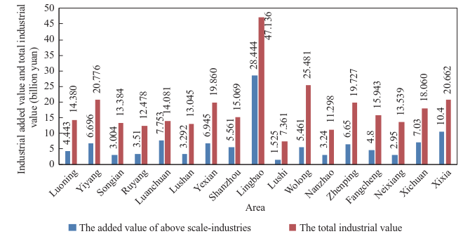
Fig. 6. The total added values of above-scale industries in the 17 counties (districts and cities) of the Qinba Mountains area in the Henan region in 2014.
《Fig. 7》

Fig. 7. The profit totals in the 17 counties (districts and cities) of the Qinba Mountains area in the Henan region in 2014.
Many natural resources in the Qinba Mountains area in the Henan region are plentiful. However, the overall industrial base is weak; industrial technology is relatively backward; and in the area’s economic development, the industrial economy runs at a low level. The Funiu Mountains, clockwise from the northern slope to the southern slope of the semicircle, are mountainous and overall represent a decreasing trend of industrial economic strength. Luoyang and Sanmenxia in the northern slope have most of the large and medium-sized enterprises.
2.4.2 Agriculture and the forestry development
The hills of the Qinba Mountains area in the Henan region account for more than 60 % of the total area. These hills are a typical mountainous agricultural region. In 2014, total grain output was 4.22 ×10⁶ t and total oil production was 7.9 ×10⁵ t. Per capita food was 358 kg, which was less than the Henan and national averages (541 kg per person and 443 kg per person, respectively). The region is essentially self-sufficient in grain. The per capita arable land area of 1.16 mu (1 mu = 666.667 m2 ), is slightly higher than the average level in Henan province (1.15 mu per person) and is lower than the national average (1.49 mu per person). Various natural medicine resources (e.g., honey suckle, forsythia, radix bupleuri, salvia miltiorrhiza, eucommia ulmoides, and cornel), an edible fungi industry, and a characteristic forestry and fruit industry (e.g., walnuts, apples, and kiwis) are nurtured in this area. The abundant agricultural, forestry, livestock, and medicinal materials resources in the area, and the quality of the environment, must be developed in order to meet the increasingly strong needs of the people, particularly with regard to the safety of food and medicine.
2.4.3 Water resources
The Funiu Mountains are the dividing line between the southern and northern slopes. The annual average precipitation of Nanyang, located on the southern slope, is 792.31 mm, and the annual average precipitations of Pingdingshan, Luoyang, and Sanmenxia on the northern slope are 790.34 mm, 684.21 mm, and 678.71 mm, respectively. The average precipitations show a decreasing trend from the southern to the northern slopes of the Funiu Mountains counterclockwise. The earth’s surface water environment is generally good in the Qinba Mountains area in the Henan region. In this region, 78 % of the earth’s surface water quality is of class I–III standard section. The water quality levels of the Huai River basin and the Yangtze River basin are good. The Yellow River basin has mild contamination. The extremely valuable water resources in the middle route of South-to-North Water Diversion Project stretch 185 km into the region, accounting for one-seventh of the project’s entire length. The project promotes excellent water prices and has laid a solid foundation for the development of the water economy.
2.4.4 The development of mineral resources
Mineral resources are rich in the Qinba Mountains area in the Henan region. By 2014, more than 50 types of mineral had been found. There are 14 minerals that rank first in China’s regional reserves. There are also 32 minerals in the top three ranks and 39 in the top five ranks. Rare and precious metal mineral resources include gold, molybdenum, vanadium, titanium, rhenium, and gallium, which have prominent advantages. The number of orefields totals 871 in Luoyang, Pingdingshan, Sanmenxia, and Nanyang in the Qinba Mountains area, accounting for 66 % of the total orefields in Henan Province. There are significant advantages for the mineral resources in the region. Terms such as “Chinese molybdenum city—Luanchuan” and the “the salt capital of China—Yexian” show that the area has developed its production volume, ranking it at the forefront of the world. Mining enterprises are numerous in the Qinba Mountains area: in 2013, they numbered 764. They accounted for 33 % of all mining enterprises in the Qinba Mountains area and 13 % of China’s total mining enterprises. However, there is a serious waste of mineral resources in the region. Moreover, environmental problems from the mines are even more serious. The rate of enhancing environmental recovery and rehabilitation is only 25 % and the local mine environmental recovery treatment rate is less than 10 %. The area needs the establishment of a dominant mineral concentration area and conformity with the provincial regional integration of mineral enterprises. Because of the different mineral resources on the southern and northern slopes in the Funiu Mountains, promoting the coordination of the green development of mineral resources between the provinces (municipalities) will improve the developmental efficiency of mineral resources.
2.4.5 Development of culture and tourism
Cultural tourism resources are rich in the Qinba Mountains area in the Henan region. Such resources have extremely important historical value, and site and relic resources are up to 543 (such as the Xixia Dinosaur Relics Park in Nanyang). The Qinba Mountains area in the Henan region is the birthplace of Buddhism, and the White Horse Temple in Luoyang is the first Chinese ancient temple. Moreover, 23 sites are on the national intangible cultural heritage (medical sage temple in Nanyang). The Qinba Mountains area in the Henan region is also the birthplace of China’s multicultural and multi-regional cultural fusion. For example, Zhengzhou is in the Central Plains Economic Zone and represents the Central Plains culture of the Yellow River; Wuhan in the Yangtze River Delta Economic Zone represents Jingchu culture; Xi’an in the Guanzhong–Tianshui Economic Zone represents the northwest Qin culture; Chongqing and Shangluo, Hanzhong, and Ankang in southern Shaanxi represent Bashu culture; and the integrated multicultural nature of minority cultures.
A large number and variety of tourism resources exist in the Qinba Mountains area in the Henan region. They cover eight main classes, with a total of 7 230 sites. Some of the tourism resources are classified at the highest levels (one world cultural heritage site, one world geological park, one world biosphere reserve, and 88 provincial levels). However, the distribution of the cultural resources is scattered; cultural and rural tourism have no scale, system, or single industry chain; and the advantages of nature, history, and rural resources are not fully utilized because of regional transportation and related service facilities in the Qinba Mountains area in the Henan region. There should be vigorous promotion of the area’s development in order to improve its visibility and influence at home and abroad.
The culture and tourism industry’s development is unbalanced in the Qinba Mountains area in the Henan region in the four municipalities under the jurisdiction of the city counties (districts and cities). The industry’s categories have different characteristics on the northern and southern slopes of the Funiu Mountains. Traditional pillar industries and high-energy loaded industries occupy important positions in Luoyang, Pingdingshan, and Sanmenxia on the northern slope. Some of the development of highgrowth industries is very rapid in Nanyang on the southern slope of the Funiu Mountains. The economic development of Luoyang and Sanmenxia on the northern slope is relatively rapid. The industrial structure is reasonable in Luoyang, the secondary industries are too prevalent in Sanmenxia, and the tertiary industries should be strengthened. The industrial structure is relatively reasonable in Pingdingshan, but the large population (1.84 million in 2 counties) is a problem, and economic development is seriously lagging behind. Development is particularly limited in Lushan County. In Nanyang, located on the southern slope, primary industries are too dominant, the large population (5.58 million in one district and six counties) is hard to manage, and the secondary and tertiary industries are in urgent need of development. Thus, the development problems are significant. The Qinba Mountains area in the Henan region should be divided into northern and southern slopes with the Funiu Mountains as the axis. This is in accordance with the different characteristics of society, the economy, and the industrial structure on the northern and southern slopes. In addition, the characteristics of ecological protection and industrial development should be investigated.
《2.5 Regional industrial development planning measures from Henan Province》
2.5 Regional industrial development planning measures from Henan Province
There are industrial development ideas from Henan Province for the Qinba Mountains area in the Henan region. In accordance with China’s overall strategy on contiguous areas with special difficulties regarding development and poverty alleviation work, effective measures should be taken for planning guidance, project implementation, and policy support. Efforts should also be undertaken to strengthen infrastructure construction, cultivate the characteristics and advantages of industries, improve rural basic production and living conditions, develop medical treatment, health, and other social undertakings, and promote the sustainable economic and social development in the Qinba Mountains area [8].
2.5.1 Strengthen planning guidance
In order to provide a clear direction for the agricultural and rural economic development of the Qinba Mountains area in the Henan region, proposals are required to improve the industrial structure and planning objectives; develop measures and policy recommendations for the economic development of agriculture and countryside in the Qinba Mountains area in terms of the fruit industry, ecological breeding industry, and green planting industry as formulating Henan province’s national economic and social development plan, the agricultural and rural special development plan, and circular economic development plan.
2.5.2 Focus on nurturing the advantages of industry
Based on the new energy resources in the Qinba Mountains area in the Henan region, especially the advantage of wind energy resources, a series of plans for constructing nine wind power projects have been proposed. These projects will have 4× 10⁵ kW of installed capacity, a total investment of 4.4 billion yuan, and provide annual clean electricity of 9.3 ×10⁸ kW·h after completion. Luoning County was included in the national green energy demonstration counties. The goal is to complete seven large-scale biogas projects, recruit 24 000 new gas users, and use 5.2 ×10⁴ t of standard clean coal renewable energy. Further measures are to support the Nanyang development of green vegetables such as peppers and edible fungi; vigorously develop a high-standard fruit-planting base and fast-growing, high-yield timber forest base; vigorously develop a biomass energy forest; accelerate the construction of an traditional Chinese medicine planting base; develop traditional Chinese medicine brands such as Xixia dogwood, Nanzhao magnolia sprengeri, Zhenping eucommia, and Fangcheng salvia miltiorrhiza; and create an efficient ecological economic demonstration area.
2.5.3 Increase the ecological compensation of the Qinba Mountains area in the Henan region
In accordance with National Planning of Main Functional Areas and the principle of “overall protection, punctate development” for promoting regional environmental protection and the ecological construction function in Henan province, efforts to enhance the ability to supply ecological products have been undertaken. These efforts are the main direction of local economic and social development. In addition, efforts have increased to support ecological compensation in the Qinba Mountains area in the Henan region. Since the 12th Five-Year Plan was issued, a total transfer payment fund of 3.958 billion yuan has been made available for nine counties. These are Luanchuan, Lushi, Neixiang, Xichuan, Xixia, Songxian, Luoning, Lushan, and Nanzhao. Nanyang is also included. The purpose is to address effectively national functional key ecological areas gradually, alleviating the effect on regional financial income through internal environmental protection in the Qinba Mountains area in the Henan region. Further, the aim is to improve the ecological construction and environmental protection of the Qinba Mountains area.
《3 Constructing the development system of green circulation based on the characteristics of “strong ecological environment” and “weak economic foundation”》
3 Constructing the development system of green circulation based on the characteristics of “strong ecological environment” and “weak economic foundation”
The Qinba Mountains area in the Henan region belongs to a national restricted development zone that is a key functional ecological zone. It faces an arduous task of ecological construction. The regional economic foundation of this area is weak. Its social and economic development lags behind the average level in China and in Henan Province. Thus, social and economic development is a very urgent task and regional economic development and ecological protection are strenuous tasks; however, the contradictions between these are very prominent.
Nonetheless, the Qinba Mountains area in the Henan region has the advantage of rich resources such as natural geographical, ecological, cultural, and mineral resources. A method of development that is integrated with modern industrial technology and network technology (Internet Plus) should be used for the area’s leapfrog development. An ecological civilization and the development of green industries are the basis of the Qinba Mountains area in the Henan region in order to establish a green cycle development system. Such a system will boost the development of the area.
《3.1 Innovating a cooperative eco-industry bidirectional gradient development mode》
3.1 Innovating a cooperative eco-industry bidirectional gradient development mode
The key industrial development area in the Qinba Mountains area in the Henan region is based on national planning of main functional areas, Central Plains economic regional planning, and the main functional zone planning in Qinba Mountains area. Such planning follows an overall principle that protects the Qinba Mountains area in the Henan region(“area” protection) and focuses on the development of a circular economic industrial park (“point” development). This accords with the overall requirements of the national development strategy, new-type urbanization, and new countryside construction. It implements the “Made in China 2025” development strategy by strengthening the relevant four provincial central cities and 17 counties (districts and cities), and considers the climate, resources, market demand, and traffic conditions. Green industry’s spatial strategic planning, together with the regional characteristics of “Internet Plus,” is proposed because it combines “industrial development” and “ecological protection.”
The edge of the key industrial development area of the Qinba Mountains area in the Henan region is south of the Longhai Railway (Luoyang–Sanmenxia–Henan and Shaanxi border section area, which connects the two central cities of Luoyang and Sanmenxia), west of the Jiaozuo– Liuzhou Railway (Luoyang–Pingdingshan–Nanyang–Henan and Hubei border section area, which connects the two central cities of Pingdingshan and Nanyang), and the border of Henan, Shaanxi, and Hubei. “Sanmenxia– Luoyang–Pingdingshan–Nanyang” is the central city circle of the wide region around the Qinba Mountains area. The 17 counties (districts and cities) are narrow-area node towns. The new bidirectional gradient joint development mode of ecology and industry in the Funiu Mountains has one circle, one belt, and two zones. It contains the central city circle around the Funiu Mountains (the outer enclosure), the green and circular development of the urban belt (17 scattered counties), the ecological agriculture zone (the transition zone), and the ecological protection zone (the core zone). Ecological protection strength has gradually increased from the outer edge to the core, and industrial development has gradually increased from the core to the outer edge, as shown in Fig. 8.
《Fig. 8》

Fig. 8. Map of the green and circular development of the urban belt, ecological agriculture area, and ecological protection zone in the Funiu Mountains.
The three connotations of the “one circle, one belt, two zones” strategic development zone of characteristic green industries are described in the following sections.
3.1.1 The key development zone (the ecological town belt)
This zone must actively promote industrialization, urbanization, and a moderately concentrated population and agglomerate industry; and improve comprehensive carrying capacity. The efficient use of resources can be achieved by optimizing the allocation of resources. This will promote green, cycle, and low carbon development.
3.1.2 The agricultural ecological zone (the transition zone)
This zone must actively develop the characteristic and high-efficient facilities and modern agriculture; cultivate the advantages of agricultural product brand; promote the development of facility agriculture; and construct a production base that is scaled, standard, professional, and characteristic.
3.1.3 The ecological protection zone (the core zone)
The construction of the ecological protection zone is based on superior ecological conditions, and characteristic regional cultural. The main issues are ecological construction and environmental protection. Cultural tourism and the water economy industry must be moderately developed. The other production and construction activities have to be limited. The ecological protection zone will be part of the national central park.
《3.2 Construction of the green and circular economy’s industrial development demonstration area on the southern and northern slopes of the Funiu Mountains》
3.2 Construction of the green and circular economy’s industrial development demonstration area on the southern and northern slopes of the Funiu Mountains
The green and circular development strategy of the Qinba Mountains area in the Henan region has two basic points: ecological protection and industrial development. The green and circular economy’s industrial development demonstration area on the southern and northern slopes of the Funiu Mountains will be constructed in accordance with the bidirectional gradient joint development mode of ecology and industry. Such construction will consider the characteristics of the area that are based on the administrative division of counties (districts and cities) and the characteristics of the area that are based on the northern and southern slopes of the Funiu Mountains, such as the society, economy, resources, and industrial structure as shown in Fig. 9.
《Fig. 9》

Fig. 9. The green and circular economy’s industrial development demonstration area on the southern and northern slopes of the Funiu Mountains.
It is essential to promote steady growth of the construction of the green and circular economy’s industrial development demonstration area on the southern and northern slopes of the Funiu Mountains. This must be undertaken in concert with an examination of the different regional features of ecological protection and industrial development of the southern and northern slopes. The ecological protection zone is the core zone, the agricultural ecological zone is the intermediate ring, and the ecological town belt is the peripheral. The spatial pattern has a strong pull and radiation force. The industrial development of the Qinba Mountains area in the Henan region and ecological protection will feed and support each other and become a model of modern industry’s green and circular development with a strong ecological condition.
《4 Promoting the construction of an industrial demonstration zone of a green and circular economy on the southern and northern slopes of the Funiu Mountains》
4 Promoting the construction of an industrial demonstration zone of a green and circular economy on the southern and northern slopes of the Funiu Mountains
The eastern part of the Qinba Mountains area in the Henan region is nearest to China’s southeast, economically developed, coastal areas. In this regard, it is convenient to undertake coastal industrial development and industrial cooperation using a radiating drive and transfer. Further, Henan province is China’s eastern and western gradient economic development plate. It has superiornatural geographic nodes and comprehensive transportation hub advantages, and is an important intersection zone of the “land and sea routes” in the national “Belt and Road Initiative” development strategy. This strategy actively implements the national strategies of the Central Plains Economic Zone, the Zhengzhou Airport Comprehensive Economic Experimental Zone, the Zhengzhou–Luoyang–Xinxiang National Independent Innovation Demonstration Zone, and so on. It will be a strong driving force for regional developmental support. The five jurisdictional cities refer to the peripheral areas of the Qinba Mountains area in the Henan region are Zhengzhou, Luoyang, Sanmenxia, Pingdingshan, and Nanyang. These have relatively perfect science, education, industry, and transportation systems. They also have a higher social and economic development level. Thus, the radiation process that is driven by the Qinba Mountains area in the Henan region has great potential for economic development. Some specific measures that are proposed in order to accelerate the construction of an industrial demonstration zone of a green and circular economy on the southern and northern slopes of the Funiu Mountains are as follows.
《4.1 Industrial development should be accelerated based on the strong ecological conditions》
4.1 Industrial development should be accelerated based on the strong ecological conditions
The “eco-industry collaborative development of a two-way gradient in the Funiu Mountains” will focus on supporting the rapid development of peripheral areas. These are the industrial gathering areas of the Funiu Mountains circular development urban zone. These are expected to develop vigorously a new energy-saving and environmental protection industry, a new energy industry, equipment manufacturing, auto parts, and other high-growth manufacturing with high technical content and market potential. In addition, they are expected to cultivate biological medicine, new energy, new materials, and other strategic emerging industries, thereby to build a modern industrial development system. Other expected developments include the implementation of the green and circular development and upgrading strategy in the strong ecological conditions of industrial and mining enterprises; the active promotion of the industrial transformation of the southern and northern slopes toward highgrowth manufacturing and highly strategic emerging industries; the acceleration of traditional machinery manufacturing, mining, and other industrial upgrading on the northern slope; and the strengthening of the in-depth processing of biological medicine, food, and other industries on the southern slope. The relocation of the core area of the current big pollution load of industrial enterprises in the “Funiu Mountains Ecological Protection Zone” to the industry-gathering areas in peripheral towns of the Funiu Mountains circular development urban zone is very necessary. The integration of the industrial agglomeration area and enterprises’ downstream industry chain, the extension of the products’ deep-processing industry chain, and the improvement of the added value of resources can ensure the realization of the industrial chain’s cycle operation. The strengthening of the existing mine ecological protection and restoration in the core area of the “Funiu Mountains Ecological Protection Zone” and the establishment of a long-term mechanism of geological environmental governance for mines area helpful to the construction of an ecological safety barrier. Moreover, it is also intended to develop vigorously “Internet Plus,” implement the developmental integration of “1+2+3” industries, and make use of industrial development in order to create more employment opportunities.
《4.2 Create areas for cultural tourism, leisure, and keeping in good health in the Funiu Mountains Ecological Protection Zone》
4.2 Create areas for cultural tourism, leisure, and keeping in good health in the Funiu Mountains Ecological Protection Zone
The cooperation of various provinces in the Qinba Mountains area should be strengthened in order to attract domestic and foreign investment. In addition, the construction of transportation and other infrastructures must continue to be promoted, reconstruction projects for rural roads must be implemented, a comprehensive transportation system must be constructed, and interoperability and open sharing must be promoted. This region can draw on the successful experience of the Rocky Mountain National Park regarding development pattern, tourism resources’ protection, and the Banff urban characteristics’ construction. It is also necessary to promote characteristic towns and tourist towns vigorously, perfect the corresponding facilities and functions, and enhance capacity in order to build the “Funiu Mountains Ecological Protection Zone” as an important part of the national central park of the Qinba Mountains area. No effort should be spared to build areas for cultural tourism, leisure, and keeping in good health that have significant international influence.
《4.3 The promotion of the rapid development of facility agriculture and the characteristic industries of forestry, fruit growing, and animal husbandry》
4.3 The promotion of the rapid development of facility agriculture and the characteristic industries of forestry, fruit growing, and animal husbandry
The government is providing guidance and encouragement to people in poor villages with bad basic conditions, such as uninhabitable areas and delicate environments, to become ecological immigrants and relocate from the Funiu Mountains Ecological Protection Zone to the industry cluster districts or ecological agricultural zones in the Funiu Mountains circular development urban zone. The aim is to accelerate the development of characteristic agriculture and avoid poverty. By means of the Internet, combined with characteristic agriculture (forestry, animal husbandry, the fishery industry, and Chinese medicine) in the Funiu Mountains, a large data network service platform regarding characteristic agricultural and sideline products is being constructed in Luoyang, Pingdingshan, Sanmenxia, and Nanyang in the Qinba Mountains area in the Henan region. The goal is to establish a network domain platform that acts as a backbone node in 17 counties (districts and cities), strengthens the network service platform, and realizes the sharing of resources through establishing a network of terminal platforms and three levels in towns. Policies and measures have been formulated by the government to encourage and guide the agricultural technology sector to provide technical services; constantly perfect product variety; improve product quality; increase the competitive power of products; and cultivate the particular green, agricultural, and sideline product brands of the region. Further aims are to strengthen the channel of rapid logistics, expand the logistics of the cold chain, shorten the time and space differences between consumers and producers, increase the degree of green processes, improve the freshness of products, and enhance the maturity of products. In order to promote agricultural modernization and the development of a wise and beauty countryside, various measures are also to be taken that benefit farmers by encouraging policy development, engaging in financial investment, strengthening foundations, improving technical services, and brand building.
《4.4 The construction of the base for Chinese vocational education and the improvement of the quality of human resources》
4.4 The construction of the base for Chinese vocational education and the improvement of the quality of human resources
The Qinba Mountains area in the Henan region is at the intersection of “Belt and Road Initiative” at the eastern frontier edge of the area. This is closest to the developed areas on the southeast coast of China and has unique geographical and human resource advantages. The region has culture, history, and folklore. The development of education (general education and vocational education) at different levels and of different types should be promoted, building the base for Chinese vocational education and training for all types of practical technical personnel. The aim is to prevent skill shortages, improve the quality of employees, and expand the number of jobs available. Education as a lever should be used to improve the development of high-tech industries related to electronic information and labor-intensive industries such as food processing, cultural tourism; import and support the growth of a group of emerging industrial enterprises to enhance the vitality of economic development and to constantly strengthen the economy. It is also important to guide a large number of young people toward starting up business and getting a job that is close to home, and promote the rapid improvement of the lives of millions of people so that they can leave poverty behind and move toward prosperity.
《5 Conclusion》
5 Conclusion
The green and circular development of the Qinba Mountains area in the Henan region is in accordance with the model of ecoindustry collaborative development of a two-way gradient in the Funiu Mountains. It also accords with the construction of an industrial demonstration zone for a green and circular economy on the southern and northern slopes of the Funiu Mountains. The excellent conditions of the Qinba Mountains area in the Henan region, such as the ecological environment, climate, air, water quality, characteristic agriculture, human resources, and existing industrial advantages, must be fully tapped. More precisely, the Funiu Mountains are surrounded by four central cities, which means that these existing industrial advantages of green and circular development urban zones in 17 counties and districts can strengthen infrastructure construction. Moreover, based on the strong ecological conditions, the development of new industries can be accelerated; areas for cultural tourism, leisure, and keeping in good health can be created; and the development of efficient agriculture, distinctive forestry, the fruit industry, and the livestock industry can be promoted. Such development also benefits the improvement of the quality of human resources and the promotion of employment and entrepreneurship when the construction of the Chinese vocational education base is carried out.
With the support and help of national and local governments, a group of livelihood projects related to education, health, culture, employment, and social security could be implemented emphatically. These projects are aimed at greatly improving production and living conditions, fostering a number of special competitive industries, and accelerating the construction of critical infrastructure. In this way, ecology and protection of the environment can be strengthened and the bottleneck that restricts real development can be eliminated. For example, ecological protection and industrial development can drive the alleviation of poverty and improve development, which in turn can promote ecological protection and industrial development. The aim of rapidly developing the economy and substantially and simultaneously building a moderately prosperous society can be achieved when the ecological environment of the Qinba Mountains area in the Henan region is further improved by 2020.
《Acknowledgements》
Acknowledgements
In the process of this study, we obtained a great deal of guidance and help from the Chinese Academy of Engineering and the Department of Chemical Metallurgy; the project leader, the vice-president of the Chinese Academy of Engineering, Xu Delong; the assessment synthesis group; the eight teams that work with indigenous groups from Shaanxi, Sichuan, Chongqing, Hubei, Gansu, and other provinces (municipalities directly under the central government); the People’s Government of Henan Province and the Henan Province Development and Reform Commission; Henan Province Bureau of Statistics; the Commission of Industry and Information Technology of Henan Province; the Science and Technology Department of Henan Province; the Department of Land and Resources of Henan Province; the Henan Province Office of Poverty Alleviation and Development, and other related departments (appointments, bureau, office) of Henan Province; and the experts in related government agencies and enterprises of Luoyang, Pingdingshan, Sanmenxia, Nanyang, and the 17 counties (districts and cities) in the Qinba Mountains of Henan. We wish to thank them all. This study is conducted by all the researchers of the eight teams in Henan. These teams include the School of Chemical Engineering and Energy at Zhengzhou University: Tang Jianwei (professor, Ministry of Industry and Information Technology), Song Xiangyu (professor, development and utilization of mineral resources); the Water Conservancy and Environment School: Wang Fuming (academician and professor, traffic systems) and Wu Zening (professor, the protection and utilization of water resources); the School of Architecture: Tong Liping (professor, the development of cities and country spaces); the School of Health Sciences: Huang Jinyong (professor, crop farming, forestry, stock farming, and medicinal materials); the Tourism School: Ren Han (professor, cultural tourism); and the School of Business: Cai Yuping (professor, policy systems). This study has been accepted by experts from within and outside the school. We wish to thank them all.


 京公网安备 11010502051620号


