《1 Introduction》
1 Introduction
Since the 21st century, the focus of the world’s offshore oil and gas exploration has entered into deep-water area. Globally, nearly half of the world’s discovered offshore oil and gas resources are distributed in deep water, and nearly 70% of the world’s major oil and gas discoveries over the past five years are concentrated in multiple, giant deep-water passive continental margin basins on both sides of the Atlantic Ocean. Deep-water area has become the main field of global oil and gas exploration and development. In China, the South China Sea is the only sea area developing deep-water basins. Within the nine-dash line, total area of the South China Sea is more than 2 × 10⁶ km2, with deep-water area (water depth > 300 m) approximately 1.5 × 10⁶ km2. Northern and southern South China Sea are divided based on 17°05' north latitude. And there are 12 major basins developed, with total area about 7.5 × 10⁵ km2. The deep-water area in the northern South China Sea covers an area of 2 × 10⁵ km2, with a depth of 300–3000 m [1]. Cenozoic sags including Baiyun Sag, Liwan Sag, Kaiping Sag, Shunde Sag, Ledong–Lingshui Sag, Songnan–Baodao Sag, and Changchang Sag are developed, with a total area of about 9 × 10⁴ km2. So, with promising prospect and great potential, deep-water area in the northern South China Sea is one of the most significant strategic areas of oil and gas exploration in China (Fig. 1) [2].
《Fig. 1》
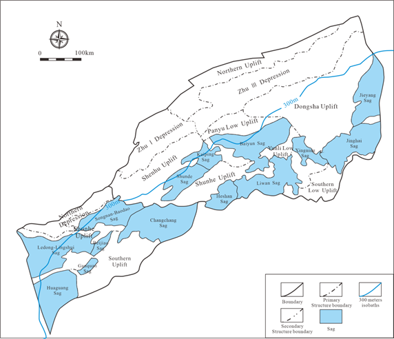
Fig. 1. Distribution of Cenozoic sags in deep-water area of the northern South China Sea.
For a long time, exploration in deep-water area of the northern South China Sea is faced with many challenges, such as rugged seabed (Fig. 2), volcanic development, poor seismic imaging, deficiency of high-quality source rocks and reservoirs, and unclear hydrocarbon accumulation model. So, the exploration risk in this area is very high. Reviewing the failure of oil and gas exploration conducted by six internationally renowned oil and gas companies, represented by British Petroleum Corporation, over the past 15 years in the South China Sea before 2000, it is suggested that successful exploration highly depend on theoretical innovations and breakthroughs of key technology. Amid the establishment of offshore large- and medium-sized gas fields, the China National Offshore Oil Corporation (CNOOC) always put the technical development as its first priority, and it has completed over 10 national, provincial, and corporate-level major scientific research projects. Through independent innovation and changing exploration ideas, the CNOOC has developed a series of crucial theories and technologies, contributing to dramatic exploration breakthroughs in deep-water area of the northern South China Sea.
《Fig. 2》

Fig. 2. Seismic profile showing rugged seabed in deep-water area of the northern South China Sea.
By 2020, 10 large- and medium-sized gas fields, such as Lingshui 17-2, and 3 large-scale oil fields, taking Liuhua 20-2 as an example, have been discovered in deep-water area of the northern South China Sea. The accumulative tertiary geological reserves of natural gas and crude oil are approximately 7 × 10¹¹ m3 and 1 × 10⁸ m3, respectively. Two established large deep-water gas fields, Deep Sea No. 1 and Liwan 3-1, and the Liuhua oilfield group are expected to annually produce over 6 × 10⁹ m3 of natural gas and 4.5 × 10⁶ t of oil.
《2 Theoretical and technological innovations and exploration breakthroughs》
2 Theoretical and technological innovations and exploration breakthroughs
After continuous research and explorations, CNOOC has developed five innovative geological theories, including the detachment-controlled basin in deep-water area of the continental margin of the northern South China Sea, the formation and hydrocarbon-generation mechanism of deep-water source rocks, the high-abundance hydrocarbon accumulation model of large axial canyon channel in deep-water area of the Qiongdongnan Basin, the controlling effect of deep-water high-variable geotherm on the differential enrichment of oil and gas in the Baiyun Sag, and the model of late oil accumulation jointly controlled by “fault-ridge” in deep-water area. In addition, two key innovative technologies were developed, consisting of the broadband acquisition and processing technology based on three-dimensional source and plow cable streamer, surface batch drilling and testing modular engineering operations. These theoretical and technological innovations offer the guidance to the deep-water oil and gas exploration and engineering operations, facilitating the discovery of many oil and gas fields, such as Lingshui 17-2 and Liuhua 20-2, which has a landmark significance in accelerating the process of deep-water exploration.
《2.1 Deep-water detachment in the continental margin of the northern South China Sea controls the formation of large-scale sags》
2.1 Deep-water detachment in the continental margin of the northern South China Sea controls the formation of large-scale sags
Based on gravity, magnetic, and seismic data, the structure of deep-water continental margin basins in the northern South China Sea is studied. And a large detachment fault system that cuts through the crust and slowly converges downward to the Moho detachment surface is firstly identified and confirmed in the deep-water continental margin area. Controlled by this large detachment fault system, the lithosphere in deep-water area of the continental margin of the northern South China Sea has undergone a non-instantaneous fracturing process of “extension, thinning, stripping, and cracking” [3], forming an extensive and large-scale detachment sag group with a total area of 1.1 × 10⁵ km2, which extends from the central depression of the Qiongdongnan Basin in the west to the Taixinan Basin in the east. The identification of marginal deep water detachment basin group profoundly changed the conventional view that the continental margin basins are previous faulted basins controlled by high-angle normal faults, indicating that strong detachment faulting can form broad and deep basin and further control the differential evolution of basin group [4]. And this provided ample space for the development of extensive source rocks and deep-water reservoirs. The discovery of the thick deep-water target strata controlled by the detachment basin has not only effectively supported the significant decision-making associated with exploration of deep-water area, but also offered reference and guidance for the research of domestic and overseas deep-water continental margin basins.
《2.2 Formation and rapid hydrocarbon-generation mechanism of three sets of large-scale source rocks in deep-water continental margin of the northern South China Sea》
2.2 Formation and rapid hydrocarbon-generation mechanism of three sets of large-scale source rocks in deep-water continental margin of the northern South China Sea
There are three sets of extensive source rocks developing in the deep basin of the northern South China Sea. They are lacustrine, marine-continental transitional, and marine source rocks controlled by lithosphere thinning, and characterized by multiple types, great in scale, and wide distribution. From Eocene to Oligocene, lacustrine source rocks controlled by high-angle faulting, marine-continental transitional source rocks controlled by detachment, and marine source rocks controlled by depression based on crustal thinning were developed in succession. In specific, lacustrine source rocks are large in scale, mostly dominated by sapropelic-type organic matter, with a characteristic of high abundance and great oil generating potential. Marine-continental transitional source rocks are largely dominated by humic-type organic matter. Within them, coal measures are extensive in distributed, varying in organic carbon content, and big in volume, which control gas generation and migration. Marine source rocks are widely distributed, generally dominated by humic-type organic matter with medium organic carbon content [5].
In Cenozoic, the continental margin in the northern South China Sea was influenced by strong mantle thermal activities [6], and the geothermal gradient increased from 3°C/100 m to 5°C/100 m from shallow to deep water. The distinctively high heat-flow field in the deep-water area contributed to the rapid and high-intensity hydrocarbon generation in these three sets of source rocks. The burial depth of the oil window can be reduced from 4000–5300 m to 2500–3300 m, while the burial depth of gas window can be reduced from 5700–6800 m to 3500m–4200 m. The threshold of hydrocarbon-generation becomes shallower, and the intensity of hydrocarbon-generation increases remarkably (Fig. 3). It is predicted that oil and gas resource potentials in deep-water area of the northern South China Sea are 7 × 10⁹ t oil equivalent, showing great prospect for exploration and development
[7].
《Fig. 3》

Fig. 3. Source rock maturity model in deep-water area of the northern South China Sea.
《2.3 Large axial canyon channel reservoir and three-dimensional efficient gas accumulation model in deep-water area of the Qiongdongnan Basin》
2.3 Large axial canyon channel reservoir and three-dimensional efficient gas accumulation model in deep-water area of the Qiongdongnan Basin
Large gas field accumulation model of the deep-water central canyon channel in the Qiongdongnan Basin is characterized by vertical migration associated with fractures, canyon channel sandstone reservoirs, mudstone associated with mass-flow capping, and high-efficiency charging (Fig. 4). The central canyon sandstone reservoirs were developed during post-rift subsidence stage. Guhonghe–Lanjiang channel systems were eroded and deposited in the central depression of the Qiongdongnan Basin, forming a large central axial canyon channel with a length of 550 km and a width of 9–35 km that is rare globally [8,9], and developing turbidite channel sand bodies. The lithologic traps formed by the channel sandstones and the enclosing hemipelagic-pelagic mudstones were reworked by differential compaction and subsequent erosion and filling, resulting in the formation of lithologic-structural complex traps. In the Neogene, especially over the past 10 million years, the western Qiongdongnan Basin was rapidly subsided under the influence of dextral strike-slip of the Honghe Fault and rapid uplift of the Qinghai-Tibet Plateau. The resulting overpressure induced the mud diapir and fault activation, and formed a pathway linking the deep Oligocene coal-bearing source rocks. Driven by buoyancy and overpressure, a three-dimensional vertical migration system with an accumulation area of about dozens of square kilometers was established. Fast and efficient charging of gas in the late stage ultimately contribute to a horizontally continuous and vertically multilayer-overlapping deep-water gas field group. A series of large- and medium-sized deep-water gas fields, for example, the Lingshui 17-2 gas field, China’s first self-run large gas field with reserves exceeding hundreds of billions cubic meters, were discovered under the guidance of this model.
《2.4 High-variable geotherm controls differential hydrocarbon enrichment and the model of hydrocarbon accumulation jointly controlled by “fault-ridge” in Baiyun Sag》
2.4 High-variable geotherm controls differential hydrocarbon enrichment and the model of hydrocarbon accumulation jointly controlled by “fault-ridge” in Baiyun Sag
There are three sets and types of source rocks developed in Baiyun Sag, including lacustrine source rocks of Lower Eocene Wenchang Formation developed during faulting period, marine-continental transitional source rocks of Upper Eocene Enping Formation developed during fault-depression period, and marine source rocks of Oligocene Zhuhai Formation developed during depression period. Shallow lacustrine and locally semi-deep lacustrine source rocks were mainly developed during the deposition of Wenchang Formation, dominated by type Ⅱ kerogen and displaying high organic matter abundance, the total organic carbon (TOC) being around 0.9%–1.7%. Marine-continental transitional source rocks were developed during the deposition of the Enping Formation, dominated by type Ⅱ2 kerogen, with subordinate type Ⅱ1 or type Ⅲ kerogen. TOC is high, approximately ranging from 0.8% to 5.8%. Terrestrial-marine source rocks were mainly developed during the deposition of the Zhuhai Formation, dominated by type Ⅱ2 kerogen, with moderate TOC and low to moderate hydrocarbon-generation potential. Controlled by high-variable geotherm, these three sets of source rocks are characterized by oil-prone at sag margin and gas-prone within sag. The present geothermal gradient in deep-water area of the Baiyun Sag is 2.94–5.22 ℃/100 m, increasing gradually from north to south. Within the sag, source rocks are primarily deep lacustrine, shallow marine, and marine-continental transitional facies, characterized by high abundance of organic matter, deep burial, and high degree of thermal evolution. As these source rocks are mostly gas-prone, gas is the main exploration target within the sag. Marginal sag and associated areas, such as eastern Baiyun Sag, largely developed shallow lacustrine to marine-continental transitional source rocks, characterized by small burial depth, relatively low degree of thermal evolution. As these source rocks generate both oil and gas, oil is the main exploration target within marginal sag [10].
《Fig. 4》

Fig. 4. Gas accumulation model of Lingshui 17-2 gas field in the Qiongdongnan Basin.
Note: T70 is the top interface of Yacheng Formation; T60 is the top interface of Lingshui Formation; T50 is the top interface Sanya Formation; T40 is the top interface of Meishan Formation; T3 is the top interface of Yellow flow Formation; T29 is the internal unconformity of the second member of Yinggehai Formation; T20 is the top interface of Song of the Yinggehai Formation
Meanwhile, under the joint control of fault-ridge, hydrocarbons are differentially enriched and accumulated in the eastern Baiyun Sag (Fig. 5). After the marine-continental transitional source rocks dominated by type Ⅱ2 kerogen reached the threshold of oil generation, the generated oil migrated upward through faults to the shallower marine sandstones. Controlled by the accumulating effect of the structural ridges associated with shallower marine sandstones, oil widely distributed in marine sandstones accumulated close to structural ridges and migrated laterally. The oil accumulated in traps along the migration pathway, forming early reservoirs between about 14.5 and 7.5 million years. With the increase of the degree of thermal evolution of source rocks, the amount of generated oil declined while there was a rise of the amount of gas. Over the past 5.5 million years, the late fault activities were controlled by Dongsha movement, conducive to the gas migration along the previous oil migrating pathways. As a result of gas displacement, the accumulated oil was driven to the further traps to accumulate, and the gas occupied the oil reservoirs to form the new gas reservoirs. Thus, the differential hydrocarbon accumulation model of gas discovered close to sag and oil discovered far away from sag was concluded [11]. Based on this model, the Liuhua oilfield group, the first large- and medium-sized oil field group in the deep-water area of the northern South China Sea, was discovered. Liuhua 21-2 oilfield will be put into production soon, and the peak annual output will exceed 4.5 × 10⁶ t. The establishment of the oil production base in the eastern Baiyun Sag is an incredible case of exploration guided by the theoretical innovation on the differential enrichment and accumulation of hydrocarbons in Baiyun Sag.
《Fig. 5》

Fig. 5. Oil and gas accumulation model of the eastern Baiyun Sag.
Note: T50 is the top interface of lower Zhujiang Formation; T70 is the top interface of Enping Formation; Tg is the top interface of base.
《2.5 Late gas accumulation model associated with deep-water fan in Baiyun Sag》
2.5 Late gas accumulation model associated with deep-water fan in Baiyun Sag
The late gas accumulation model in the Baiyun Sag can be summarized as gas generation from highly mature source rocks, gas migration through diapir and fault, gas accumulation in deep-water fan sandstone reservoirs, and late charging of gas. Deep-water fan sandstone reservoirs of the Baiyun Sag were formed in early Miocene. 23.8 million years ago, Baiyun movement had a significant influence on the deep-water continental slope sedimentary environments. The ancient Pearl River delta from the north formed large-scale deep-water fan sand bodies in the sag. The presence of nose structures and faults contributed to the formation of structural-lithologic complex traps or lithologic traps. The lacustrine source rocks of Wenchang Formation and the marine-continental transitional source rocks of Enping Formation underneath or adjacent to the traps started to generate a large amount of gas and few oil 15 million years ago with the increase of burial depth and geothermal temperature.
Over the past 10.5 million years, affected by Dongsha movement, several diapiric structures and a large number of north–west-trending faults connecting deep and shallow intervals were developed in the Baiyun Sag in the course of successive subsidence. Meanwhile, early north–east-trending faults were further activated. Subject to overpressure and buoyancy, gas generated from the source rocks of the Wenchang and Enping Formation migrated vertically or vertically and laterally. The above is concluded as late gas accumulation model associated with deep-water fan [12]. The model guided hydrocarbon exploration and discovered Liwan 3-1 gas field in deep-water area, and the proved geological reserves of gas are nearly 5 × 10¹⁰ m3.
《2.6 Broadband acquisition and processing technology based on three-dimensional source and plow cable streamer》
2.6 Broadband acquisition and processing technology based on three-dimensional source and plow cable streamer
Multiple three-dimensional source acquisition and processing technologies were developed, which contribute to optimizing seismic wavelet, expanding band width, eliminating the interference of “ghost wave”, and improving seismic resolution, imaging quality, and the signal to noise ratio of the target intervals. Techniques such as wave equation pre-stack depth domain amplitude preserving migration, far-offset superposition waveform stretching, and anisotropic velocity optimization have been developed to improve the seismic imaging quality of deep-water rugged seabed so that the true tectonic morphology can be restored [13].
Developing broadband acquisition and processing technology based on plow cable streamer has solved the world-class problem of “ghost wave” interference, which has plagued maritime seismic imaging for many years. The operating depth of the cable is 5–50 m. The ratio of the length of the diagonal cable to the length of the horizontal cable is 2:1 to 3:1. The cable sinking precision is 0.5 m. On the basis of these technological innovations, the width of the seismic band is widened from 3 to 5 octaves. The low-frequency end is extended from 6 to 3 Hz, and the high-frequency end is extended from 80 to 120 Hz. Besides, the basic frequency is increased by 15–20 Hz. Overall, this technology has taken the lead internationally (Fig. 6) [14].
《Fig. 6》

Fig. 6. Schematic diagram of three-dimensional source and plow cable streamer acquisition.
《2.7 Surface cluster batch drilling and testing modular engineering operations》
2.7 Surface cluster batch drilling and testing modular engineering operations
By establishing the selection model of cluster batch drilling optimization scheme, and through the simulating research on all operating conditions associated with inter-well shift on platform in the soft and hard suspension modes, the structural responses of riser under various operating conditions were determined. Combined with the operating rules in riser soft suspension mode and blowout preventer hard suspension mode, permissive velocities of inter-well shift on platform are obtained, which solved the safety and technical problems brought about by inter-well shift on platform in soft and hard suspension modes and established surface cluster batch drilling. Because of the efficient drilling and evaluation of sand body group in the deep-water central canyon zone of the Qiongdongnan Basin, time and cost are significantly saved.
Through the deep-water test equipment selection, structure strength examination, surface process optimization, and modular combination design, technology system associated with deep-water test surface equipment modular design was formed, dominated by deep-water test equipment integrated technology, surface process optimization design technology, surface equipment modular design and examination technology, and surface equipment modularization associated secure and efficient installation and debugging technology. Hydrate prevention, sand production, vibration monitoring, and emergency shut-off or bypass functions are realized at temperatures ranging from −20 ℃ to 130 ℃, pressures of 15 000psi, and gas flow rates of 2.2 × 10⁶ m3/d, ensuring the safety of the platform for testing the limit capacity under high production-allocation conditions in deep-water development. The application of the modular deep-water test process reduced offshore installation time from 30 days to 10 days and disassembly time from 16 days to 4 days, saving 22 days per well, 40% of the available deck area, and more than 100 million in test costs.
《3 New challenges and strategies》
3 New challenges and strategies
Although currently some breakthroughs have been made in deep-water oil and gas exploration, the establishment of the deep-water major gas-developing area in the northern South China Sea still faces new challenges, including the further research and innovations on “basin formation, hydrocarbon generation, reservoir development, hydrocarbon accumulation”, as well as seismic acquisition and processing technology.
(1) Prototype basin restoration in the deep-water area of the northern South China Sea. Subject to low signal-to-noise ratio and poor imaging quality of deep-strata seismic data, caused by less and unevenly distributed drilling data, large water depth, rugged seabed, and complex subsurface geological structures, there are still controversies with respect to the deep-water area of the northern South China Sea, including division and correlation of interbasinal and intrabasinal Eocene-Oligocene, and restoration and paleogeographic reconstruction of superimposed basin. Geological and geophysical division and correlation technology of mid-depth, deep strata will be prioritized, especially utilizing the methods of magnetic anomaly, paleontology, paleoclimate, isotope, etc. In addition, under the guidance of the theory of oil and gas accumulation in deep-water areas controlled by tectonic cycles in marginal seas [15], prototype basin restoration will be conducted through genetic comparison of tectonic interfaces, prototype restoration technology of conjugate continental margin basins, and structural analysis and restoration technology.
(2) Forming mechanism and distribution prediction of terrestrial-marine source rocks. Globally, hydrocarbon-generation material of Mesozoic and Paleozoic marine source rocks is mainly planktonic algae and types of organic matter are different, so there is almost no enough experience for reference. Moreover, the coupling relationship between biogenesis and geological origin of the organic matter enrichment in marine source rocks and associated geological-geochemical responses are not clear, along with the unclear distribution of source rocks, so there is no effective prediction technology with respect to the distribution of terrestrial-marine source developed. The origin and enrichment of organic matter in terrigenous source rocks and their genetic relationship with sedimentary environments will be focused. Dynamics simulations of hydrocarbon generation and expulsion will be further researched. Then, hydrocarbon expulsion mechanism and efficiency of the Cenozoic terrigenous-marine source rocks will be clarified. And, based on sedimentary organic facies, a comprehensive geological-geophysical prediction technology of terrigenous-marine source rocks will be developed.
(3) Evaluation of deep clastic reservoir in the context of high-variable geotherm. There are few deep wells in the deep-water area of the northern South China Sea, so it is difficult to identify and characterize high-quality reservoirs. High-variable geotherm generally leads to accelerated reservoir diagenesis and as a result, permeability of reservoirs is commonly lower. However, its forming mechanism is unclear. Moreover, on account of the smaller impedance difference of deep clastic rocks, it is difficult to predict reservoirs geophysically. Forward and inversion of the clastic rock systems within the sequence framework will be conducted to clarify the distribution of the deep coarse clastic facies associated high-energy environments. The diagenetic controlling mechanism of high-quality reservoir in the context of high-variable geotherm will be studied. Sensitive parameters of geophysical prediction of reservoir are determined through numerical simulation and physical simulation, so as to develop the technology of deep reservoir back-stripping and high-quality reservoir geological prediction applying to the high-variable geotherm in deep-water area.
(4) Hydrocarbon migration and accumulation under “deep water-deep strata” and “high temperature-high pressure” (double deep and double high). Under the condition of “double deep and double high”, the hydrocarbon phase states and accumulation dynamics are complex. In addition, the study of hydrocarbon migration and accumulation dynamics is not readily. Due to the absence of effective technology for the restoration of hydrocarbon accumulation process, quantitative simulation of hydrocarbon migration and accumulation cannot be achieved. The temperature and pressure fields of the basin in different periods will be restored. Physicochemical properties and phase state characteristics of deep-sourced fluids and its relationship with basin evolution will be studied. Basin burial process analysis, integrated with evolution of three fields (temperature, pressure, and stress fields), hydrocarbon generation dynamics, reservoir diagenetic dynamics, and hydrocarbon migration and accumulation dynamics, the technology for the three-dimensional dynamic restoration of source–accumulation–reservoir and the prediction of dominant migration paths will be developed. Then, comprehensive, multi-dimensional, full-scale quantitative simulation of hydrocarbon generation, migration, and accumulation processes will be achieved. Meanwhile, accurate prediction of the scale and distribution of hydrocarbon zones and reservoirs can be accomplished.
(5) High-precision seismic data acquisition and processing technology associated with mid-depth and deep strata. At present, there are still interferences associated with steep continental slope, rugged seabed, and igneous rocks in deep-water area. Poor-quality seismic imaging of the mid-depth and deep strata, and the conventional-band, narrow azimuth seismic data cannot meet the exploration requirements of deep-water complex target exploration. And the costly acquisition and the difficult seismic data processing result in the generally low degree of industrial promotion. So, with respect to acquisition, multi-vessel mixed acquisition with streamer cable will be further researched and the efficiency of seismic acquisition with “two widths and two heights” in deep water will be improved. Besides, the independent research and development of ocean-bottom nodes (OBN) seismic data acquisition technology and equipment will be enhanced. In terms of processing, it will focus on the processing technology for “two widths and two heights” seismic data collected by rich low-frequency excitation, streamer cable, and OBN, so as to improve the integrated application ability of processing and interpretation of “two widths and two heights” seismic data.
《4 Exploration prospect of deep-water area in northern South China Sea》
4 Exploration prospect of deep-water area in northern South China Sea
Promoting energy supply-side structural reform, vigorously developing green and low-carbon energy, accelerating the usage of gas and other clean energies, and optimizing the energy structure and distribution of the Guangdong–Hong Kong–Macao Greater Bay Area are the inevitable requirements of the blueprint for the new era and new opportunities for deep-water hydrocarbon exploration and development. After several generations of CNOOC explorers, especially the successful production of Deep Sea No.1 gas field (Lingshui 17-2 gas field), the one-trillion gas area in the northern South China Sea is ready to emerge, and the exploration and development of deep-water gas is becoming more significant in the construction of large gas areas.
In terms of resource potential, exploration in the deep-water area of the northern South China Sea is still at an early stage, with 3.9 × 10¹¹ m3 of proven gas resources and 3.6 × 10¹² m3 of undiscovered gas resources, among which the deep-water area of Baiyun Sag of the Pearl River Mouth Basin and the Qiongdongnan Basin are 1.8 × 10¹² m3 respectively. Natural gas to be discovered is mainly distributed in four sags: Baiyun Sag, Ledong Sag, Lingshui Sag, and Songnan-Baodao Sag, with an area of more than 1 × 10⁴ km2. Therefore, there is still potential for the discovery of 100 billion cubic meters of gas fields in the deep-water area.
With respect to exploration, natural gas is mainly enriched in the mid-depth and deep strata, buried hills, and lithologic traps [16].
(1) Mid-depth and deep strata exploration. Ninety percent of the oil and gas reserves in the deep-water area have been discovered to be distributed in the Neogene (< 3300 m), and the wells with a depth of more than 3500 m account for only 10% of the total number of wells. Baiyun 5-2 structure is a representative of the exploration in the mid-depth and deep strata of Baiyun Sag, which is located in the northern slope zone of Baiyun Sag. The zonation of coal-bearing source rocks shows that the slope zone of the sag is a favorable exploration zone. The main target strata, Zhuhai Formation and Enping Formation with a buried depth more than 3500 m, show that the thickness of gas-bearing intervals proven by drilling are more than 100 m. It is concluded that the Paleogene in the northern slope zone, southeastern slope zone, and southwestern step-fault zone of Baiyun Sag in the Pearl River Mouth Basin, and the Paleogene in the central depression and its margin of the Qiongdongnan Basin are favorable zones for deep-water exploration, and the resource prospect is about 3.5 × 10¹¹ m3.
(2) Buried hill exploration. Mesozoic Indosinian granite buried hill is developed in the deep-water area of the northern South China Sea. Currently, breakthroughs have been made in the eastern deep-water area of the Qiongdongnan Basin, showing a good potential for exploration [17]. Yongle 8-3 buried hill gas reservoir has been discovered on Songnan low uplift in the Qiongdongnan Basin. Lithologically, the reservoir is Pre-Cenozoic reddish granite and its vertical zoning is prominent. Sandy gravel weathering zone, weathering fracture zone and inside-hill fracture zone are developed from the surface to the inside, having porosity of 18.6%, 7.7%, and 9.7%, respectively. The reservoir is well-developed, displaying good physical properties, and the thickness of gas-bearing interval proven by drilling is about 85 m. The test output is 1.3 × 10⁶ m3. It is concluded that the southwest step-fault zone, southeast uplift in Baiyun Sag of the Pearl River Mouth Basin, and the Lingnan–Songnan low uplift in the Qiongdongnan Basin are the favourable zones for buried hill exploration in the deep-water area, with a resource prospect of 3 × 10¹¹ m3.
(3) Lithologic trap exploration. Exploration of lithological trap is still in its initial stage. Miocene and Pliocene in the deep-water area of continental slope of the northern South China Sea are inferred to be conducive to developing submarine fan, so the exploration potential is great. There has been breakthrough in submarine fan exploration in the deep-water area of the Qiongdongnan Basin, with the gas-bearing interval proven by drilling is approximately 50 m. The turbidite sandstone of the submarine fan is medium in porosity and permeability, interpreted to be good-quality reservoir. And along with the overlying deep-water mudstones, good reservoir-cap assemblage was developed. It is concluded that delta frontal–turbidite fan in the northern continental slope, the stratigraphic overlap zone of the southeastern continental slope of Baiyun Sag in the Pearl River Mouth Basin, and submarine fan in the central depression of the Qiongdongnan Basin are the main exploration zones, with a resource prospect of 2.5 × 10¹¹ m3.
《Compliance with ethics guidelines》
Compliance with ethics guidelines
The authors declare that they have no conflict of interest or financial conflicts to disclose.


 京公网安备 11010502051620号


