
《1 Introduction》
1 Introduction
The Qinba Mountain Area spans the Qinling Mountains, the Daba Mountains, and several other branch mountains. It is located in the central hinterland of China and constitutes a geographical, climatic, and cultural boundary on a north-south axis (Fig. 1). Given its significant ecological function, this area is relatively less developed and suffers from the incompatibility of ecological environmental protection with urban and rural socioeconomic development [1]. A series of published policy documents—Outline of Poverty Alleviation and Development in China’s Rural Areas (2011–2020), Danjiangkou Reservoir Area and Upstream Economic and Social Development Plan and Hanjiang Eco-Economic Belt Development Plan—explains the gradual integration of the Qinba Mountain Area into the national development framework. Exploring the green transformation and development of urban and rural space in this area has demonstrative significance for the coordinated development of the urban agglomeration around Qinba and even the whole country. Therefore, this paper focuses on the characteristics of urban and rural basins in the Qinba Mountains. It uses a multi-scale framework, considering the basin as a base unit, to carry out an analysis of the regional basin development that aims to provide theoretical support for the green development of regional urban and rural space.
《Fig. 1》

Fig. 1. Range of the Qinba Mountain Area.
《2 Research background》
2 Research background
《2.1 Regional overview》
2.1 Regional overview
The Qinba Mountain Area starts from the eastern edge of the Qinghai Tibet Plateau in the west and extends to the southwest of the North China Plain in the east. It covers five provinces (Gansu, Sichuan, Shaanxi, Henan, and Hubei) and one city (Chongqing). It comprises 22 cities with 119 districts and counties with a registered population of about 61.64 million and a total area of about 3.086 × 10⁵ km2 . The region hosts the Yangtze River, the Yellow River, and the Huaihe River, and more than 80 rivers originate here, including the Weihe River, the Hanjiang River, the Jialing River, the Danjiang River, and the Luohe River. Furthermore, the Danjiangkou Reservoir, the largest artificial freshwater lake in Asia, has become an important water source for China’s South-to-North Water Transfer Project. The Qinba Mountain Area is not only an important ecological barrier for national ecological and homeland security but also a convergence point for the Belt and Road initiative. Although the region is rich in water, heat, forest, grass, and mineral resources, its ecological environment is fragile: natural disasters are frequent; poverty is concentrated and continuous; internal development is unbalanced; the level of social and economic development is relatively low; and the industrial base is still weak compared with the developed areas in the east [2].
《2.2 Existing problems》
2.2 Existing problems
2.2.1 The urban and rural system structure is imbalanced, and the human-land conflicts are prominent
The urban and rural space in the Qinba Mountain Area hosts a large population; however, the geographical spatial distribution is unbalanced. Most of the urban and rural units are relatively small and scattered, and the spatial distribution of the population and economic activities and the level of socioeconomic development are highly dependent on the natural landform. On the one hand, the average level of urbanization in the region is only 37.0%, lagging behind that of China’s average (58.5%); on the other hand, the urbanization rates of county-level cities in the region reinforces the characteristic that the east and the outer edges are stronger than the west and the center.
The imbalance and insufficiency of urban and rural socioeconomic development in the Qinba Mountain Area results in the imbalance of urban and rural system structure, the differentiation in urban development as observed in the co-existent and parallel urban and rural spatial pattern of “metropolitan” areas with relatively high economic development levels and “large rural” areas with relatively lagging development levels.
2.2.2 Administrative divisions are independent, which hinders the coordinated green development of urban and rural areas
In the Qinba Mountain Area, the traditional administrative divisions break the integrity of the urban-rural ecosystem. The division and management of administration hampers effective allocation and market-oriented operation of the regional ecological resources. The externalities of public development resources are prominent, and there are many barriers to ecological environment protection, water resource allocation, and water pollution control. As a relatively complete and systematic natural ecological unit in the region, the Qinba Mountain Area is often horizontally and vertically cut by administrative departments and industry management. This results in the fragmentation of urban and rural space governance in the region.
For a long time, the Qinba Mountain Area has lacked an overall plan and management of cross-regional coordination agencies. The absence of overall regional-level regulation and control and the independent planning of various administrative divisions in different units lead to a lack of cooperation and linkage in the layout of upstream/midstream/downstream industries as well as infrastructure and public service facilities. The low utilization efficiency of regional urban and rural development resources, the lack of gradient level and strategic depth in urban and rural development and construction, the low degree of coordination of urban and rural human settlements, and the serious lack of endogenous development power lead to regional poverty [3]. The deterioration of the regional ecological environment and deep poverty have remained a constant, and urban and rural green development has been difficult to coordinate.
《3 The necessity of urban and rural space development in the Qinba Mountain Area based on basins》
3 The necessity of urban and rural space development in the Qinba Mountain Area based on basins
《3.1 Considering the basin as a planning unit can effectively help to analyze the landscape characteristics of urban and rural environments in the Qinba Mountain Area》
3.1 Considering the basin as a planning unit can effectively help to analyze the landscape characteristics of urban and rural environments in the Qinba Mountain Area
The regional geomorphological and geological conditions of the Qinba Mountain Area are extremely complex. The “two mountains and basins” region has remarkable features. A natural hydrological process is closely related to the mountain environment; there is a symbiotic relationship between urban-rural space development and the basin hydrology (Fig. 2). The strong coupling between urban and rural human settlements and the characteristics of the mountain basins have bred the unique human settlements of the Qinba Mountain Area. As a river catchment surrounded by a water line, the basin is not only a natural hydrological/ecological unit [4] but also a system of “ecology–culture–society–economy” [5]. Because of the scale effect of the mountain hydrology, basin units of different scales have their own integrities and differences. Considering the basin as a planning unit can effectively maintain the integrity of the Qinba Mountain Area’s natural hydrological and ecological processes. Compared with the traditional administrative units, the natural basin as a unit is more suitable as a comprehensive research unit for a system of “natural ecology–social economy–resource management–spatial planning.”
《Fig. 2》
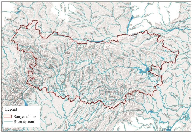
Fig. 2. Distribution map of the Qinba Mountain’s regional water system.
《3.2 Considering the basin as a cognitive perspective can help to realize the green coordination of urban and rural development in the Qinba Mountain Area》
3.2 Considering the basin as a cognitive perspective can help to realize the green coordination of urban and rural development in the Qinba Mountain Area
In the Qinba Mountain Area, land carrying capacity and spatial development suitability vary among different landforms such as river valleys, hills, and mountains. Under the influence of the market mechanism, especially in the process of rapid urbanization, one can observe the expansion and contraction effect of urban and rural space along the river valleys, hills, and mountains. The effect showcases “core–edge” characteristics, especially the imbalance of urban and rural socioeconomic development within and between the river basin units. Considering the basin as a cognition perspective can help to overcome the traditional administrative division’s negative effects on the basin’s ecological process; support the establishment of an inter-administrative, regional operation mechanism for the basins; and avoid “upstream water diversion, middle water blocking, and downstream water cutoff.” Effective allocation of urban and rural development resources; reasonable arrangement of urban and rural industries, major facilities, and human settlements in the basin; and improving the operation efficiency of urban and rural space are prerequisites for the coordinated development of ecological protection measures and green development in the Qinba Mountain Area.
《3.3 Considering the basin as an overall planning unit is conducive to promoting the convergence of urban-rural spatial planning and institutional management/control of the Qinba Mountain Area》
3.3 Considering the basin as an overall planning unit is conducive to promoting the convergence of urban-rural spatial planning and institutional management/control of the Qinba Mountain Area
For a long time, basin management in the Qinba Mountain Area has been based on the ecological and economic construction in the area, which is mainly reflected in resource protection and development, water control, and mountain management. However, this development has not been effectively connected with an urban-rural spatial planning system. This situation leads to a lack of guidance for land spatial planning and inefficient spatial management and control systems. As a remedy, the spatial planning of the river basin should be combined with the management of the riverhead and consider the more comprehensive objectives: ecological governance, environmental protection, and urban development. We should give full play to the mature advantages of the “river chief system,” overcome the development dilemma that “the problem is in the water, the root is on the shore,” and achieve all-round control and comprehensive management of urban and rural space in the basin. Considering the basin as an overall planning unit is conducive to a transformation from the urban-rural governance model based on administrative divisions to a hierarchical governance model based on the river basin. Furthermore, it is conducive to the overall planning of the spatial management of mountains, water, forests, fields, lakes, grasses, and other natural resources; the establishment of a new land spatial planning system; and the formation of a top-down, systematic, and efficient spatial management and control system.
《4 Delineation of the multi-scale basin basement in the Qinba Mountain Area》
4 Delineation of the multi-scale basin basement in the Qinba Mountain Area
《4.1 Construction of the basin order framework》
4.1 Construction of the basin order framework
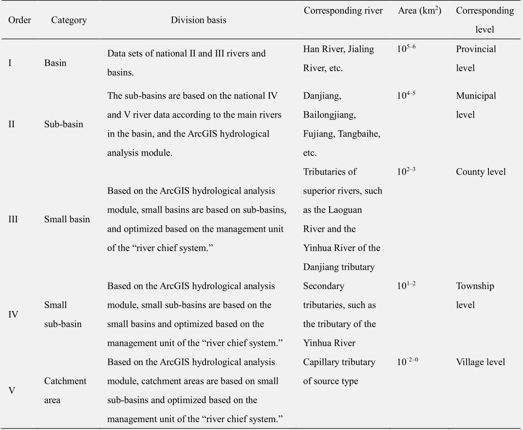
At present, there are no clear guidelines to help delineate the basin space. The best practices in the United States apply a five-level scale in basin space planning comprising basin, small and medium basin, small basin, catchment area, and catchment unit (Table 1) [6,7]. However, most of the basin-related planning in China focuses on macro-scale strategic planning that usually involves water resources, infrastructure, economic development, and other aspects. Medium- and micro-scale soil and water conservation and environmental governance is also exercised.
《Table 1》
Table 1. The definitions of scale ranges for basin planning in the United States (revised according to reference [6]).

The framework, contents, and planning and management of different scales of basins in the Qinba Mountain Area requires systems thinking. The current system fails to form an effective connection among urban and rural areas, land use, and other elements of spatial planning; it is weak in connection, control, and guidance for the spatial planning of the basin. Therefore, based on the characteristics of the regional landscape environment, by drawing on the relevant best practices of basin planning in the United States, and with the help of a multi-scale hierarchical delineation, we have outlined a five-level, nested, macro-to-micro scale spatial framework: “province–city–county–town/urban–village.” (Table 2).
《Table 2》
Table 2. The basin order framework in the Qinba Mountain Area.
《4.2 Delineation of multi-scale, nested basin units》
4.2 Delineation of multi-scale, nested basin units
According to the ten-basin system in China, the Qinba Mountain Area mainly involves the Yangtze River, the Yellow River, and the Huaihe River. Among them, the Yangtze River Basin (located in the upper part of the middle section) constitutes the core of the Qinba Mountain Area, as it is the most important water resource. It plays a role in the conservation and transportation of clean water sources coming from the three rivers as well as other important water sources in the middle section. The relevant areas account for 78% of the research area. Using the ArcGIS spatial information platform [7], we overlaid the core area of the Qinba Mountain Area over the next-level basin of the first-level river (i.e., the second-level basin of China) to comprehensively delimit the first-level basin of the Qinba Mountain Area.
Based on this delimitation, we performed a detailed analysis using the ArcGis hydrological analysis module [8]. We used the Pfafstetter River coding system to name the basin unit [9] and systematically defined the second-level basin of the Qinba Mountain Area. For example, the Hanjiang River has 32 sub-basins, with a minimum basin area of 1187.85 km2 , a maximum basin area of 10 752.35 km2 , and an average area of 4400.69 km2 . By analogy, we defined the third, fourth, and fifth-level basin units (Fig. 3).
《Fig. 3》

Fig. 3. Basin delineations in the Qinba Mountain Area.
《5 Urban and rural space development in the Qinba Mountain Area based on basins》
5 Urban and rural space development in the Qinba Mountain Area based on basins
《5.1 Urban and rural structure based on the ecological management and control of the basins》
5.1 Urban and rural structure based on the ecological management and control of the basins
Based on the delimitation of the ecological security pattern, using the basin as an integral planning unit and considering the relationships among units, this paper puts forward an urban and rural spatial structure for the Qinba Mountain Area: “one core with four cores, one ring with two domains, and multi-point support” (Table 3, Fig. 4). The proposed structure is comprehensive and benign; rural and urban factors freely flow, industries collaborate, the land is utilized in a competitive manner, and the value chains circulate and update [10]. Establishing this structure and relationships could rationally guide rural and urban population mobility and industrial agglomeration and promote the coordinated green development of urban-rural space in the Qinba Mountain Area.
《Table 3》
Table 3. Structural elements of urban and rural space in the Qinba Mountain Area.

《Fig. 4》
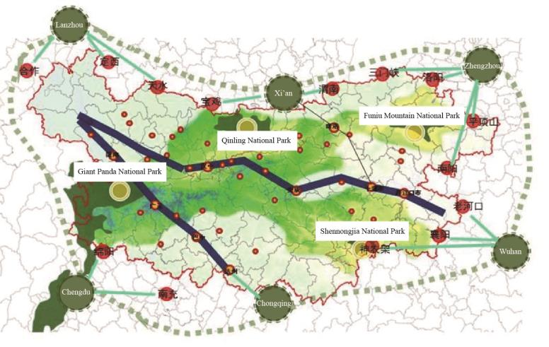
Fig. 4. Structure of urban and rural space in the Qinba Mountain Area.
《5.2 Urban and rural model guided by green transformation based on basins》
5.2 Urban and rural model guided by green transformation based on basins
Based on the multi-scale basin planning framework for the Qinba Mountain Area, we selected the small basin unit to further deepen the research. Given the basic conditions of urban and rural ecology, industrial development trends, and practical problems; the macro development strategy of the basin; and guidance for hierarchical and classified management, we propose different types of small-basin urban and rural green development modes: full green, dark green, medium green, and light green (Fig. 5).
《Fig. 5》
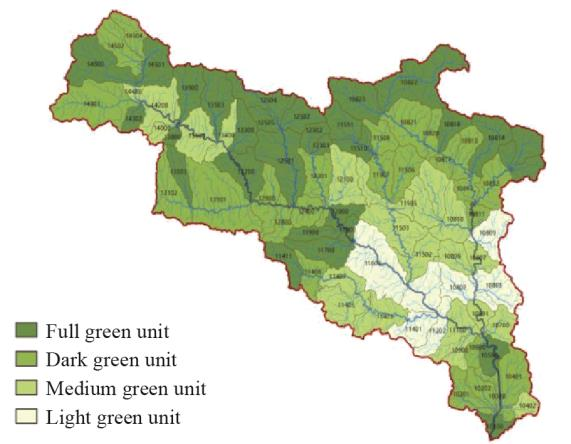
Fig. 5. Full green, dark green, medium green, and light green units of the Danjiang Basin.
5.2.1 The full green development mode
The full green development mode is suitable for the upper reaches of the river basin where the altitude is high, the terrain fluctuates, and the ecological environment is extremely sensitive or the area’s ecological service function is extremely important, e.g., the nature reserve and the water conservation land. Given this kind of a fragile ecological environment and a low bearing capacity of resources and environment, a reduction in urban and rural populations and human settlements has become an inevitable trend. We should guide the urban and rural populations to transfer to the central villages or towns in the middle and lower reaches with flat land-use conditions and convenient transportation. This transfer should be gradually implemented by means of ecological migration and village relocation.
Furthermore, we should integrate urban and rural land use in areas that are ecologically sensitive and prone to frequent natural disasters; promote the conversion of farmland to forest and grass; and remove existing buildings or structures that do not serve the protection of ecological functions. Except for major infrastructure or public facilities, urban and rural construction should be prohibited in principle. We should implement the most stringent ecological protection policies and limit the development of mining, processing, and other industries that negatively impact the environment.
5.2.2 Dark green development mode
The dark green development mode is suitable for the middle and upper reaches of the basin, with high altitude and large-scale topographic relief. Most of these areas are close to the nature reserves and ecologically sensitive, or they provide important ecological functions. The scale of urban and rural settlements should be controlled in these areas. Appropriate demolition and consolidation activities should be carried out for villages and towns with complex terrains, small populations, or inconvenient transportation; the layout of public service facilities in the basin should be improved; and the spatial structure of urban and rural settlements in the small basins should be integrated and optimized.
In combination with the existing industrial layout, we should develop and build green processing points, family workshops, agricultural and sideline products markets, etc. for agricultural, forestry, and livestock products. Simultaneously, we should introduce leisure tourism to villages and towns that are close to the scenic area and have better ecological environment or protection of traditional features. We should also strictly control the development and construction activities that greatly impact the ecological environment. We should especially forbid projects causing high levels of pollution and energy consumption. It should be prohibited to carry out commercial exploration, mineral resource development, and production and construction activities that are irrelevant to ecological protection and functions in areas such as natural reserves, scenic spots, and forest parks.
5.2.3 Medium green development mode
The medium green development mode is mostly suitable for the middle and lower reaches of the river basin, at relatively low altitudes and driven by the radiation from the central city (town). These should be centralized construction areas for regional industries in the future. Urban development should be carried out under strict protection guidelines that consider the potential threats to the ecological environment.
We define the control zone for urban development according to the principle of “point development and general protection.” Land for urban and rural construction should be rationally allocated and large-scale industrialization and urbanization should be restricted. Expansion without proper planning should be prohibited; the construction density of urban and rural clusters should be appropriately increased; and the compact and intensive construction of urban and rural space should be guided. We should actively develop green industries and modern characteristic agriculture and raise the level of production in farming and animal husbandry. Thus, we could strengthen the construction of high-quality agricultural product bases and the demonstration zones for high-standard farmlands; resolutely put an end to industrial projects that cause pollution; and strictly control and regulate open-air mining activities such as mountain quarrying.
5.2.4 Light green development mode
The light green development mode is generally suitable for the middle and lower valley areas with low altitudes, small topographic relief, and low sensitivity to the ecological environment. These areas are potential areas for intensive urban and rural spatial layouts. For such areas, it is advisable to reasonably assess and predict the urban population and the scale of land use, delimit the ecological red line of the basin and the boundaries of urban (town) spatial growth.
We should introduce “green” into cities (towns) and cities to mountains and rivers, reasonably organize urban functions, arrange urban and rural space in an orderly way, optimize the urban-center system, and create functional urban groups with balanced occupation, suitable production, and residences. Furthermore, we should strictly restrict high levels of energy consumption and pollution, and other industrial projects in the basin and strive to develop green industries such as new energy, new materials, medicine, and processing of agricultural products. We should promote the concentration of industries from villages and towns to parks; build circular industrial parks; and realize the ecological, chain, and scientific development of urban and rural industries.
《5.3 Coordinated management and control that centers on the interactive development of basins》
5.3 Coordinated management and control that centers on the interactive development of basins
On the one hand, coordinated management and control that centers on interactive development of basins clarifies the “synergy” between the basin units and emphasizes the strategic coordination of the upstream, downstream, and within-basin urban agglomerations. On the other hand, it strengthens the “controllability” and highlights the layered and hierarchical management and guidance of urban and rural development in the basin. With the goal of interactive development and starting from a place of systematic thinking regarding coordination, management, and control, the first-level and second-level basins should be further clarified as collaborative units, and the third-level small basin, the fourth-level small sub-basin, and the fifth-level catchment areas should be clarified as control units.
5.3.1 Collaborative units
Considering the first and second-level river basins as the macro planning units, and the Yangtze River and the Yellow River basins as the main body, will strengthen the strategic coordination around the Qinba Mountain Area urban agglomeration (Qinba City Area). As the basins are located in the upper reaches of the Yangtze River and the middle reaches of the Yellow River, we should start by ecological protection, development and utilization of water resources, and construction of urban and rural infrastructures to promote the unity of the strategic objectives and paths of the upper/middle/ lower reaches of the basin, to optimize the regional urban and rural spatial layout.
5.3.2 Control units
As a micro-guide and controlling unit, the fourth and fifth-level basins implement and give coherence to the superior spatial strategic planning, aiming to build a community of “ecology–economy–industry–management” based on the basin as an ecological planning unit. Through the construction of the index system and with the guidance of an optimization strategy, urban and rural development at different levels of the basin units could be brought under refined control.
In the specific control process: (1) Based on the ecological suitability zoning, resource and environment carrying capacity, and land development suitability zoning of small basins, ecological network planning could be carried out to form a spatial management and control system of “three areas and one network”; (2) Focus would be on the red line of ecological protection, the protection lines of permanent basic farmlands, urban development boundaries, environmental quality bottom line and resource utilization line of the small sub-basins; and on simultaneously implementing the negative list for environmental access and forming the “five lines and one single” spatial management and control system of the small sub-basin; and (3) Guided by the management and control of the ecological space, through ecological and water quality inspections and the control of the river section in the catchment area, we could strengthen ecological protection and restoration measures for the basin and comprehensively form the “three controls and one implementation” spatial management and control system for the catchment area.
《6 Conclusion》
6 Conclusion
Given the status quo and characteristics of urban and rural construction and development in the Qinba Mountain Area, we should consider the basin as a systematic connection unit in planning; explore and recognize the “landscape” characteristics of the regional urban and rural space to implement the appropriate development modes; and construct urban and rural residential communities with multi-dimensional elements comprising nature, economy, society, and culture. This paper provides theoretical guidance and significant practical implications as a reference for the green, circular, and sustainable development of urban and rural space in the Qinba Mountain Area.
Considering the basin as the central planning unit, this paper examines the spatial management of the Qinba Mountain Area, studies the spatial development of regional urban and rural areas, strengthens the regional strategy for the development of green human settlements, defines a multi-scale basin framework, and puts forward the spatial development strategy for the regional development and management of green urban and rural areas. The green and circular regional development of the Qinba Mountain Area has a long way to go, and the green transformation of urban and rural spaces requires complex systems engineering. Thus, a follow-up, multi-disciplinary research will be valuable.


 京公网安备 11010502051620号


