
《1 Introduction》
1 Introduction
The development of the real-time and intelligent space-based information service system enables high-performance integrated real-time services of positioning, navigation, time-service, remote sensing and communication (PNTRC) [1,2], which can solve the problems associated with building overseas foundation reinforcement stations for the Beidou satellite navigation system (Beidou System for short), and can guarantee the commanding points of communication/navigation/remote sensing integration services. It is also an important driving force for China to realize “overtaking at a curve” in the field of space technology, and to promote the innovation and development of satellite remote sensing, satellite communication, satellite navigation, and other related industries.
There is a huge gap between the response speed and coverage of China’s aerospace information and the world’s leading level [3–9]. Taking the United States as an example, relying on the aerospace information network, the response period from the detecting to containing targets anywhere in the world is about 10 min. In contrast, China has not yet fully established an aerospace network link. From the detection of sensitive events to transferring information, processing information, and making a decision response, the duration of the whole response to global events is more than 10 h. The construction and application of the system will significantly improve the response speed and coverage, and is expected to approach or even partially reach an advanced level compared with other nations. It is predicted that by 2035, China will launch more than 200 smart remote sensing and navigation enhancement satellites, deeply integrate existing and planned space-based systems to build a global service system, master the global space-based information rights, and develop a new paradigm in which space-based information is popularized, commercialized, and covers a global scale.
At present, the world’s major aerospace countries have focused on competition with respect to low-orbit communication satellites and remote sensing satellite constellations, and they have invested huge amounts of resources to achieve the rapid development of these systems. However, the concept or plan of the integrated communication/ navigation/remote sensing space information service system has not been proposed, and there is also no relevant construction experience. While China’s PNTRC is forward-looking, the construction and operation of the system are expected to face technical challenges in the future. Therefore, detailed performance evaluation and virtual verification should be carried out to determine the feasibility and overall efficiency during the demonstration of relevant programs, and prior to construction, the system simulation is an effective tool to meet this important demand.
To study the comprehensive effectiveness of PNTRC, it is necessary to network all kinds of existing communication satellites, navigation satellites, remote sensing satellites and other space platforms in China, as well as to realize the flexible cooperation of various tasks through cooperative observation and information relay. Owing to the absence of a reference for the existing system, it is impossible to directly determine the network structure with optimal application efficiency. This therefore needs to be explore with the help of the system simulation results, and it is important to find the best solution by comparing the performance of various options. This study performs a large number of simulation architecture designs and numerical experiments with the requirements of PNTRC construction demonstration, and the advantages and disadvantages of various construction plans are analyzed based on the evaluation results in order to provide directional suggestions for breakthroughs in system core technologies.
《2 Research status of simulation and evaluation on spatial information system》
2 Research status of simulation and evaluation on spatial information system
The real-time and intelligent space-based information service is an important form of spatial information network, which is a space-based system composed of several low-orbit satellites (more than 100) carrying high-resolution visible light, infrared, or synthetic aperture radar (SAR) and navigation-enhanced loads. Considering the large-scale, highly dynamic, fast time-varying characteristics of spatial information networks, the commonly used simulation model of spatial networks has a high degree of abstraction, and more are analyzed on a single simulation software for specific applications or specific communication backbones [10]. However, there is a need for system-level simulation technology with scalable capabilities in order to develop spatial information networks. We can further evaluate the subsystems, future scalable services, and overall efficiency of real-time and intelligent space-based information service based only on system level simulations. At present, distributed simulation service frameworks, such as high-level architecture (HLA), run-time infrastructure (RTI), and data distribution service (DDS) are mostly used in large-scale system simulations [11,12]. Scalability and distributed simulation system architectures are inevitable trends in the development of simulation system, but there have been few studies on the adaptability of node objects, topological characteristics, and information flow characteristics in spatial information networks.
The goal of the real-time and intelligent space-based information service is to support positioning, navigation, timing service, remote sensing, and communication information services. The various businesses and applications mentioned above have different index systems. (1) With respect to the communication service, Lu Na et al. [13] proposed an index system composed of an anti-electromagnetic interference performance and anti-destructive threat performance for evaluating the anti-jamming performance of satellite communication systems. Xu Xiangli et al. [14] proposed an indicator system under the four domains of physics, information, cognition, and society, focusing on the function and performance of satellite communication systems in operation fields. (2) With respect to the remote sensing service, Peng Geng [15] proposed the capability evaluation index system, which focuses on the effective duration of specific tasks, and is tightly coupled with applications (tasks) for the information support capability problems of remote sensing satellite systems. Qin Pengcheng et al. [16] designed an evaluation model to determine the contribution rate based on task requirements, focusing on the contribution rate to SOS for remote sensing satellite applications. (3) With respect to navigation, positioning, and timing services, Duan Yajun et al. [17] constructed the model of a comprehensive effectiveness evaluation system based on indicators that reflect the main functions of the satellite navigation system; Guo Shuren et al. [18] proposed that the service performance and evaluation index system of satellite navigation should focus on the space and time benchmark, navigation signals, and other core indicators, based on which the service performance specification of BDS-3 was designed.
The real-time and intelligent space-based information service has time-varying characteristics, and can schedule multiple functions to jointly complete a single task, while a single index system and static evaluation method will not be able to evaluate the effectiveness of such a complex network system. Therefore, the simulation of a space-based information network system such as the proposed real-time and intelligent space-based information service is being done similar to that of a hierarchical index system and spatial-temporal dynamic evaluation. The heterogeneity of the real-time and intelligent space-based information service is strong, and there is a multi-level interlaced coupling relationship between the information flow carrying the service and the communication network. It is difficult to describe the characteristics of various business flows and the relationship between the business flow, network characteristics, and user experience quality using a single and deterministic model. Moreover, it is only by coupling all kinds of network factors and modeling of the real-time and intelligent space-based information service can we thoroughly analyze the cause of network space-time characteristics, enabling us to implement accurate evaluation and optimization techniques [19, 20].
《3 Overall analyses of PNTRC simulation and evaluation》
3 Overall analyses of PNTRC simulation and evaluation
The PNTRC satellite constellation is composed of a large number of satellites, and simulation and evaluation research requires the evaluation of not only a single satellite, but also the entire system. The PNTRC service capability is divided into three parts according to different functions: communication service capability, remote sensing service capability, and navigation positioning and timing service capability, and the overall service capability is a comprehensive index.
《3.1 Simulation and evaluation of communication》
3.1 Simulation and evaluation of communication
PNTRC involves a variety of networks, including low-orbit communication satellites, remote sensing satellites, navigation satellites, and ground networks. It has the characteristics of a highly dynamic network topology, diverse information flows, and heterogeneous nodes. After comprehensive analysis, PNTRC can be abstracted as a multilayer spatial model on temporal networks, and the communication capability analysis can be conducted from multiple perspectives.
Various types of communication satellites that are in use have different communication functions and service capabilities, and there is a need for corresponding evaluation index requirements. For example, for satellite communication required for military operations, more attention should be given to stability and security, and the development of evaluation indicators should focus on anti-electromagnetic interference performance and anti-destructive threat performance; for satellite communications during combat, considering sea/land/space/sky multi-dimensional maneuverability, regional scope, and information reliability, we should focus on factors such as coverage, information protection, and adaptive capabilities. Considering the communication service that is planned for PNTRC, which is to overcome the limitations of insufficient coverage of the terrestrial communication network and to realize the integration of the world-wide mobile broadband communication transmission, we should focus on the coverage capacity, communication capacity, and communication quality, etc. in order to establish an index system of communication capability simulation and evaluation.
《3.2 Simulation and evaluation of remote sensing》
3.2 Simulation and evaluation of remote sensing
Remote sensing satellites mainly carry out tasks such as detection, perception, and continuous monitoring, and they have the characteristics of transit back (information). The communication capability of PNTRC solves the problem of remote sensing satellite information transmission, and the evaluation of remote sensing satellites therefore focus on the remote sensing capabilities. The simulation design should focus on the information acquisition capability, and the imaging acquisition model should be applied.
Satellite remote sensing involves a wide range of technical content. There are various classification standards and multi-type evaluation programs with respect to remote sensing capabilities. For example, for the system information support capabilities of remote sensing satellites, more attention is given to the degree of matching to specific tasks, and the effective duration of services in the evaluation indicators is critical. For the PNTRC remote sensing service, which aims to obtain optical and radar video data in real time, the simulation evaluation model of the remote sensing capability can be developed using the target recognition rate, imaging quality, single working time, and other indicators based only on the remote sensing capability.
《3.3 Simulation and evaluation of navigation positioning and timing》
3.3 Simulation and evaluation of navigation positioning and timing
Satellite navigation systems provide a variety of services, including navigation positioning, timing, information support, environmental detection, and meteorological support, and there exist various performance specifications and index systems. For example, the U.S. global positioning system (GPS), Russia’s global satellite navigation system (GLONASS), and Europe’s Galileo satellite navigation system (Galileo) have their own standards. PNTRC combines the related satellites in BDS according to their functions, and evaluates its navigation positioning and timing capabilities. The BDS capabilities can be used as a reference standard.
Positioning accuracy, timing accuracy, speed measurement accuracy, and other indicators constitute the ability of navigation positioning and timing. Most evaluation studies are carried out based on functional indicators. For example, with respect to the service performance indicators of BDS, GPS, and GLONASS, a number of performance indicators are evaluated after performing a comparative analysis. Further, with respect to the PNTRC navigation positioning and timing services, which mainly include the real-time positioning accuracy of the order of several meters and decimeters, high-precision real-time navigation information, precise timing of the order of nanoseconds, time information, and synchronization information, we should focus on the assessment requirements for service accuracy, such as the spatial resolution, positioning accuracy, horizontal protection level (HPL), and accuracy, based on which it is possible to develop a simulation and evaluation model of navigation positioning timing capabilities.
《4 Key technologies of PNTRC simulation and evaluation》
4 Key technologies of PNTRC simulation and evaluation
《4.1 Scalable and efficient distributed simulation technology》
4.1 Scalable and efficient distributed simulation technology
4.1.1 Scalable design of simulation scene
PNTRC is used to support and provide the high-performance integrated real-time services of navigation, positioning, timing, remote sensing, and communication. In the process of PNTRC simulation analysis, according to the characteristics of different services, a variety of simulation software packages (such as OPNET [21] and Exata [22]) are used to build simulation models. The interface protocol may be compatible with a variety of simulation software tools (such as STK software). While realizing the matching and compatibility of various simulation software tools, it can achieve the design goal of scalable simulation scenarios.
4.1.2 Distributed simulation for large-scale and multi-scene application
The real-time and intelligent space-based information service involves many entities, such as satellites, earth stations, user stations, fixed users, and mobile users, and inter-satellite and ground-to-satellite links operate in complex and dynamic environments. If only a single simulation software is used for the scenario design, link planning, service deployment and performance analysis output, there will be significant problems such as low efficiency and high coupling. Distributed simulation divides the whole simulation task into several modules according to the characteristics of the composition structure, and a single module performs local function simulation independently; cross-module information interaction is achieved through the underlying support modules, thereby jointly completing the overall simulation task.
The PNTRC simulation architecture includes the network simulation unit, channel and link simulation unit, effectiveness evaluation unit, task planning unit, demonstration unit, and the console unit (Fig. 1). Each functional unit is interconnected by HAL/RTI. The console unit realizes the control and configuration of the integrated simulation process based on the simulation parameter configuration. The task planning unit performs route planning and calculates output planning based on scene and business parameters, and sends the result file to the simulation and demonstration unit. The network simulation unit generates the simulation configuration files according to the simulation parameters, accepts console commands to start simulations, and sends the statistical indicators to the demonstration and evaluation unit in real time during the simulation process. The channel and link simulation unit is integrated with MATLAB simulation software [23] to simulate the channel and link. The demonstration unit illustrates the scene according to the demonstration scene parameters, the planning result files, and output indicators during the simulation. Finally, the effectiveness evaluation unit evaluates the effectiveness of navigation enhancement, on orbit information processing, and network communication based on the evaluation algorithm.
《Fig. 1》
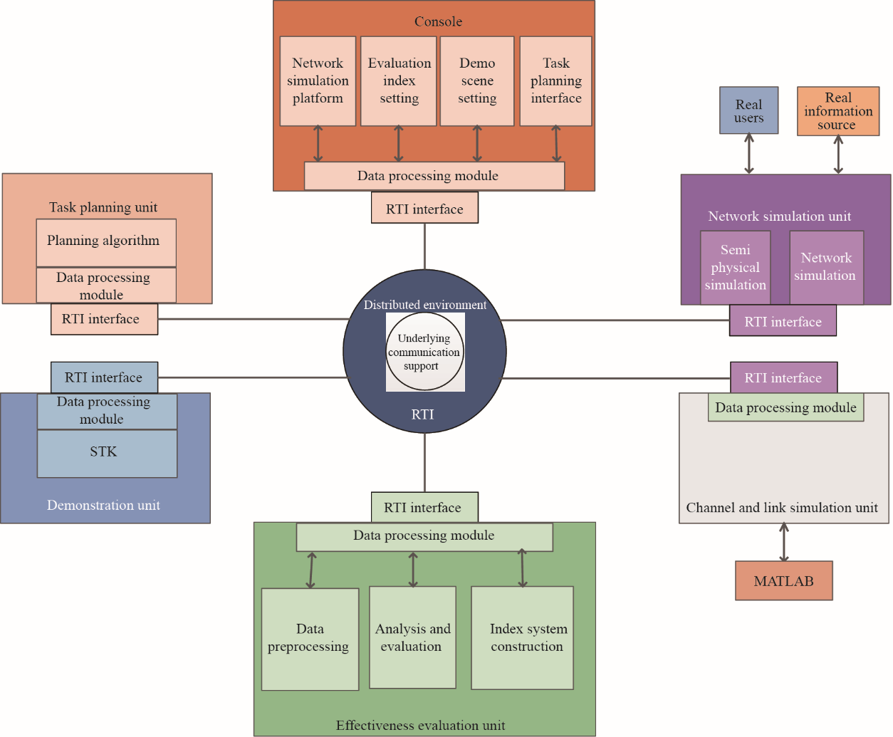
Fig. 1. Composition diagram of PNTRC simulation functional unit.
《4.2 Evaluation technology for dynamic space-based information system simulation》
4.2 Evaluation technology for dynamic space-based information system simulation
4.2.1 Construction of multi-level index system
The PNTRC function has expansibility in that a single task can be completed by a combination of multiple functions, and a single function can be supported by multiple capabilities of the system, so the index system used for simulation and evaluation should be multi-level. The selection of an index system should fully consider all aspects of the system capacity in order to implement quantitative evaluation, reasonably determine the importance of each index, and select the index weight. Usually, a multi-level evaluation index system is used to decompose the objectives according to the needs, and to divide the levels according to the relationship between factors to clarify the structure.
4.2.2 New evaluation technology based on time-varying graph analysis
(1) Model construction and data processing of time-varying graph
PNTRC simulations have large scale, dynamic, and longtime consumption, and the index data are multi-dimensional vectors. With respect to the simulation system architecture and network characteristics, the construction of a network model and the algorithm design of dynamic performance simulation data based on time-varying graph theory were carried out. In order to retain the characteristics of network changes, typical simulation data were extracted as evaluation samples. This kind of algorithm can express the characteristics of the new evaluation system, and it has the advantages of low complexity and an intuitive display of network timing changes.
(2) New evaluation technology of space-based information system
This study analyzed the technical features of the current mainstream evaluation methods, optimized and improved the algorithm design ideas based on the concept of entropy value/fuzzy model for the dynamic data structure of PNTRC application features and time-varying graph features, and proposes a new evaluation algorithm (including dispersion, ambiguity, combination, and relation), which is suitable for dynamic change simulation data. This kind of new algorithm can objectively evaluate the system simulation performance (data-based evaluation) while maintaining interpretability (experience-based weighting) and have good performance in dynamically evaluating time-varying graph data. In addition, the new algorithm has a lower time and space complexity, and can meet the actual needs of multiple simulation data evaluations in the same scenario through parameter configuration.
(3) System contribution rate of indicators
The system contribution rate represents the allocation of output performance uncertainty to each input variable, and can provide a basis for the reliable design of the system and the rational simplification of the evaluation model. The system contribution rate algorithm based on random forest uses the information of input variables (index information), such as the distribution range and fluctuation, to measure the contribution of the uncertainty of input variables to the network performance. By using this algorithm, the network structure can be optimized and the comprehensive efficiency of PNTRC simulation results can be improved.
《4.3 PNTRC simulation system modeling》
4.3 PNTRC simulation system modeling
4.3.1 Modeling of space-based information network based on simulation data
The simulation of a space-based information network involves: (1) construct a partial system model, integrate it with the structure and function, and build the whole simulation system; (2) design simulation experiment parameters according to the actual state of PNTRC; (3) using the simulation platform, implement the PNTRC working process simulation, and carry out multiple simulations for different design parameters and operating goals; (4) multiple simulations provide data about the uncertainty of the simulation system and output corresponding statistical indicators; (5) driven by simulation statistics, output data and network design parameters, and analyze the global modeling of spatial information network.
The modeling process driven by simulation data mainly includes: (1) extract design elements based on target requirements, such as service access bandwidth and communication routing methods; (2) rely on a simulation platform, such as OPNET, to carry out parameter design and to complete the construction of the simulation model; (3) by quantifying the real-time simulation data, extract the performance index under the corresponding system capacity; (4) use a new type of evaluation algorithm to evaluate the performance indicators, which can improve the extraction of elements, optimize the parameter design, and improve the PNTRC simulation model.
4.3.2 Modeling of space-based information network for dynamic information
The important feature of PNTRC is its very dynamic nature, that is, the topology of the space-based information network is constantly changing. The network is complex in time and space, but it has certain rules: with a specific spatial configuration, the time dimension presents periodicity and rhythm, and it also has the characteristics of “multi-network linkage” and “multi-domain hinge.” These features should be comprehensively and appropriately considered when modeling PNTRC. This paper is based on the generalized mixed-probability process (HPP) model and the weight degradation upper bound (WDUCB) criterion, and proposes a Bayesian optimization method for the representation and arrangement of a multimodal heterogeneous network model to meet the requirements of dynamic multi business scenarios of spatial heterogeneous networks. The simulation results show that the proposed method has good performance in terms of heterogeneous dynamic network representation and optimization.
《5 Application of simulation and evaluation for PNTRC remote sensing service》
5 Application of simulation and evaluation for PNTRC remote sensing service
The space-based information real-time intelligent service simulation and evaluation system will be used to carry out simulation analysis and efficiency evaluation for the PNTRC remote sensing service. As a theoretical study, select the representative low-orbit communication constellation and PNTRC remote sensing constellation in China and abroad for network services; China Aerospace Science & Industry Corporation (CASIC) plans to build a Hongyun network, China Aerospace Science and Technology Corporation (CASC) plans to build a Hongyan network, and One Web Corporation of America plans to build a One Web network. The performance comparison of the three networking services was obtained by performing simulations, and provides a design reference for building a more optimized spatial information network architecture in the future.
《5.1 General case of remote sensing constellation and low-orbit communication constellation》
5.1 General case of remote sensing constellation and low-orbit communication constellation
The advantage of the cross-constellation networking service is that by taking advantage of the low-orbit communication constellation, PNTRC remote sensing data will be instantly transmitted to a coverage area spanning the entire globe. In other words, the ability of the PNTRC remote sensing constellation cannot be achieved independently. Using the simulation and performance evaluation system, this study compares the service performance of the three networks Hongyun, Hongyan, and One Web with the PNTRC remote sensing constellation.
The designed orbit height of the PNTRC remote sensing constellation is 500 km, with a total of 15 orbital planes, each of which has six satellites; ten of the satellites are randomly selected for simulation experiments. There are 11 ground stations (all located in China), which are located in Beijing, Chengdu, Fuzhou, Guangzhou, Guiyang, Harbin, Hohhot, Jinan, Urumqi, Wuhan, and Xining. Under the condition that all ground stations carry out related services, the average number of satellites that can simultaneously provide access services during the operation of the Hongyun network is 11, the average number for the Hongyan network is eight, and the average number for the One Web network is 12.
《5.2 Transmission performance analysis of PNTRC remote sensing service》
5.2 Transmission performance analysis of PNTRC remote sensing service
According to the needs of the PNTRC remote sensing service transmission performance evaluation, the key indexes, such as the packet loss rate and delays, of the remote sensing video and image service are then analyzed.
When transmitting remote sensing video services, One Web has a better packet loss performance and delay than Hongyun and Hongyan networks (Figs. 2 and 3), because One Web has a greater constellation coverage. However, the coverage of One Web is more dense, the beam angle of each satellite is smaller, and there are a larger number of beam switching processes. In the case of increased video service flow because the duration of the video stream transmission is generally longer than other services, frequent beam switching will result in an increased delay to some extent.
《Fig. 2》
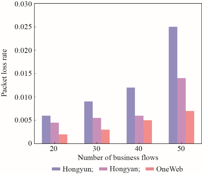
Fig. 2. Comparison of packet loss rate in remote sensing video service.
《Fig. 3》
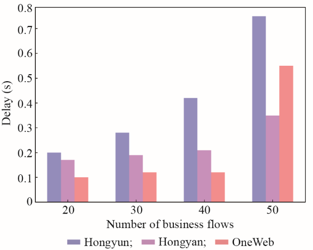
Fig. 3. Comparison of delays in remote sensing video service.
When transmitting remote sensing image services, One Web has a larger intensive coverage and more available satellites, so the packet loss performance and delay are better than those of the Hongyun and Hongyan networks (Figs. 4 and 5); that is, it has a higher capacity and stability. In addition, the duration of remote sensing image transmission services is generally relatively short, the instantaneous data traffic is large, and frequent beam switching during the transmission process has little impact on the service performance.
《Fig. 4》
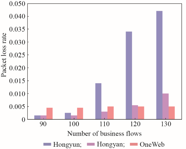
Fig. 4. Comparison of packet loss rate in remote sensing image service.
《Fig. 5》
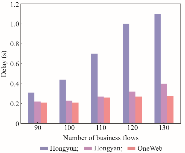
Fig. 5. Comparison of delays in remote sensing image service.
《5.3 Analysis of single-satellite communication capacity of low-orbit communication satellite》
5.3 Analysis of single-satellite communication capacity of low-orbit communication satellite
For the remote sensing video service and remote sensing image service, the single-star service capacity of the PNTRC remote sensing constellation was calculated according to the number of available remote sensing services above (Figs. 6 and 7).
With the increased number of satellites in network constellations, the total service capacity of the remote sensing video and remote sensing image services is also increased, but the improvement range is not linear: Hongyun has a higher single-star capacity than both Hongyan and One Web. Focusing on the future global coverage requirements of the PNTRC remote sensing service, the single-satellite coverage service capability of the low-orbit communication constellation still needs to be further improved.
《Fig. 6》
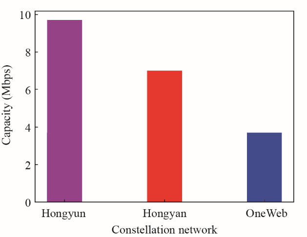
Fig. 6. Comparison of single-star capacity in remote sensing video service.
《Fig. 7》
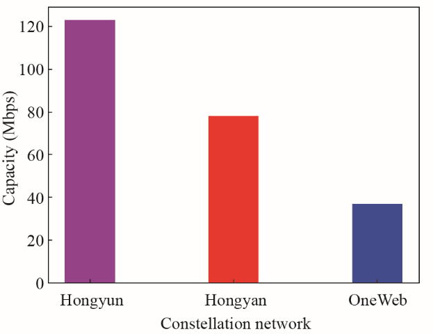
Fig. 7. Comparison of single-star capacity in remote sensing image service.
《6 Conclusion》
6 Conclusion
According to the demonstration and construction requirements of PNTRC, this study analyzed the overall characteristics of PNTRC communication, remote sensing, navigation, positioning, and timing services based on the research status of simulation and evaluation in spatial information system, and focused on the key technologies involved in PNTRC simulation and evaluation, such as efficient distributed simulation, dynamic system simulation, and simulation system modeling. Based on the development of a simulation evaluation system, the application research for PNTRC remote sensing service was completed, and the performance comparison with Hongyun, Hongyan, and One Web networks was obtained, which provides a design reference for the building of a more optimized spatial information network architecture in China.
The integration of the communication/navigation/remote sensing services of PNTRC makes it easy to realize the combination of military and civil functions, which has good potential value for national security, economic, and social development. Simulations and evaluations are important to strengthening and optimizing the top-level design of PNTRC. Based on the network modeling driven by big data and the discovery of network elements, it is expected to play a significant supporting role for the optimization and construction of PNTRC. The simulation and evaluation research will also be focused on distributed simulations, spatiotemporal dynamic analysis and evaluation, systematic modeling, and model generalization.


 京公网安备 11010502051620号


